Shawangunk, New York
Shawangunk is a town in southwestern Ulster County, New York, USA. The population was 14,332 at the 2010 census.[3] Like the neighboring mountain range, for which it is named, it is pronounced either as the Munsee Lenape, Shawangunk /ˈʃɑːwəŋɡʌŋk/, or as the colonial Shongum /ˈʃɒnɡʌm/ SHON-gum by local residents. (See Shawangunk Ridge.)
Shawangunk | |
|---|---|
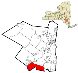 Location in Ulster County and the state of New York. | |
| Coordinates: 41°36′59″N 74°13′59″W | |
| Country | United States |
| State | New York |
| County | Ulster |
| Government | |
| • Supervisor | John Valk Jr.[1] |
| Area | |
| • Total | 56.55 sq mi (146.46 km2) |
| • Land | 56.06 sq mi (145.18 km2) |
| • Water | 0.49 sq mi (1.28 km2) |
| Elevation | 335 ft (102 m) |
| Population | |
| • Total | 14,332 |
| • Estimate (2016)[4] | 14,063 |
| • Density | 250.87/sq mi (96.86/km2) |
| Time zone | UTC-5 (Eastern (EST)) |
| • Summer (DST) | UTC-4 (EDT) |
| FIPS code | 36-66674 |
| GNIS feature ID | 0979486 |

History
Shawangunk was first settled by Europeans around 1670. The region was organized as a precinct in 1743, and became the town of Shawangunk in 1788. The town's name comes from the Dutch translation of the Munsee Lenape. The Lenape pronunciation for the town was "Scha-WAN-gunk." In Lenape, "Schawan," means "it is smokey air." This was given as referring to the nearby Catskill Mountains which were known as the "hidden mountains." The mountain ridge that runs from southwest to northeast creates a heavy humidified atmosphere that would make the Lenape believe the area had smokey air. A Lenape linguist, Raymond Whritenour, suggests that the name comes from the burning of a Munsee fort by the Dutch in the year 1663. This fort was nearby a creek later known as the Shawangunk Kill and also what is now known as Old Fort Road. The burning of the fort signaled the end of the Second Esopus War and helped spread the name to the nearby ridge by the early 1700s. Present-day citizens of Shawangunk refer to themselves as living in particular hamlets such as Wallkill or Pine Bush rather than the town as a whole; this has been in part due to the large size and growing population of the town and the fact that Wallkill is the designation for the local post office.[5]
Geography
According to the United States Census Bureau, the town has a total area of 56.5 square miles (146 km2), of which, 56.2 square miles (146 km2) of it is land and 0.3 square miles (0.78 km2) of it (0.55%) is water.
The south town line and half of the east town line is the border of Orange County, New York.
The Wallkill River flows through the eastern half of town and lends its name to the hamlet, which it flows through. The western part of the town, including Walker Valley, climbs the slopes of the eponymous mountains.
Government
The Town of Shawangunk is lead by a supervisor and a board of four council members. The current supervisor is John Valk, Jr., in office since 1998.
List of supervisors of Shawangunk:[6][7]
| Name | Years Served | Notes |
|---|---|---|
| Jacobus Bruyn III | 1744-1747 | |
| Cornelius Bruyn | 1748-1749 | Brother of Jacobus |
| Benjamin Van Keuren | 1750 | |
| Isaac Hasbrouck | 1751-1752 | Member of Hasbrouck family |
| Jacobus Sammon | 1753 | |
| Johannis Jansen | 1754-1760 | |
| Benjamin Van Keuren | 1761 | |
| Johannis Jansen | 1762 | |
| Benjamin Van Keuren | 1763-1764 | |
| Johannis Jansen | 1765-1768 | |
| Benjamin Van Keuren | 1769 | |
| Johannes Hardenbergh Jr. | 1770 | |
| Johannis Jansen | 1771-1772 | |
| Johannes Hardenbergh Jr. | 1773-1775 | |
| Cornelius C. Schoonmaker | 1776-1777 | Served as New York State Assemblyman (1777-1790) following term |
| Thomas Jansen Jr. | 1778-1779 | Brother of Johannis |
| James Hunter | 1780-1781 | |
| Cornelius C. Schoonmaker | 1782-1783 | Served as United States Congressman (1791-1793) years after this term |
| Thomas Jansen Jr. | 1784 | |
| James Hunter | 1785 | |
| Cornelius Bruyn | 1786-1793 | Son of Jacobus III; nephew of Cornelius |
| Justus Banks | 1794-1796 | |
| Joseph Isaac Hasbrouck | 1797-1799 | Son of Isaac, member of Hasbrouck family |
| James Kain | 1800-1803 | |
| Abraham Bruyn | 1804-1805 | Son of Cornelius; nephew of Jacobus III; first cousin of Cornelius |
| Stephen Rea | 1806 | |
| Albert Roosa | 1807 | |
| Stephen Rea | 1808-1812 | |
| Joseph Isaac Hasbrouck | 1813-1814 | |
| Beverly Kain | 1815-1816 | Brother of James |
| Joseph Isaac Hasbrouck | 1817 | |
| Abraham J. Hardenbergh | 1818-1821 | Relative of Johannes Jr.; previously served as New Paltz Town Supervisor |
| Johannes "John" Jansen | 1822-1826 | Son of Thomas Jr., nephew of Johannis |
| George G. Graham | 1827-1835 | |
| Hezekiah Watkins | 1836-1841 | |
| Cornelius A. Bruyn | 1842-1844 | Son of Abraham, grandson of Cornelius; great-nephew of Jacobus III; cousin of Cornelius |
| Eli Van Keuren | 1845 | |
| James N. Mitchell | 1846 | |
| Samuel Dill | 1847 | |
| Eli Van Keuren | 1848-1851 | |
| Hector S. Webb | 1852-1855 | |
| Matthew Jansen | 1856 | Son of Johannes, grandson of Thomas Jr., great-nephew of Johannis |
| Egbert N. Brink | 1857-1858 | |
| Edmund Bruyn | 1859-1860 | Great-grandson of Jacobus III; relative of Abraham, Cornelius, Cornelius, and Cornelius A. Bruyn |
| Cornelius Abram Jansen Hardenbergh | 1861-1867 | Great-nephew of Abraham J. Hardenbergh; relative of Johannes Hardenberg Jr.; cousin of Johannis, Thomas Jr., Johannes and Matthew Jansen |
| Eli Van Keuren | 1868-1869 | |
| Abram N. Deyoe | 1870-1872 | |
| Thomas Fulton | 1873 | |
| Samuel Dill Jr. | 1874-1875 | Son of Samuel |
| Cornelius Abram Jansen Hardenbergh | 1876-1882 | Served as New York State Assemblyman shortly after this term (1885 to 1886) |
| Elias Mulford | 1883-1884 | |
| Walstein Childs | 1885-1892 | |
| Benjamin F. Dickinson | 1893-1895 | |
| D. Barclay DuBois | 1896-1897 | |
| Benjamin F. Dickinson | 1898-1901 | |
| George J. Alsdorf | 1902-1907 | |
| William W. McElhone | 1908-1917 | |
| Robert H. Terwilliger | 1918-1919 | |
| Frank J. Wilkin | 1920-1921 | |
| Joseph F. Scott | 1922-1927 | |
| George E. Halliday | 1928-1929 | Died in office |
| Lester C. Terwilliger | 1935 | Relative of Robert |
| Edward E. Murray | 1936-1946 | |
| Jesse McHugh | 1951-1965 | |
| Charles E. Penney | 1965-1969 | C.E. Penney Drive in Wallkill named for him |
| M.J. Oscar Smith | 1969-1972 | |
| Francis V. Garrison | 1972-1975 | |
| Charles Flynn | 1979 | |
| John Scott | 1987-1988 | |
| John Valk Jr. | 1998-Present | Re-elected in 2019 |
Demographics
| Historical population | |||
|---|---|---|---|
| Census | Pop. | %± | |
| 1790 | 2,128 | — | |
| 1820 | 3,372 | — | |
| 1830 | 3,681 | 9.2% | |
| 1840 | 3,886 | 5.6% | |
| 1850 | 4,036 | 3.9% | |
| 1860 | 2,870 | −28.9% | |
| 1870 | 2,823 | −1.6% | |
| 1880 | 2,910 | 3.1% | |
| 1890 | 2,456 | −15.6% | |
| 1900 | 2,406 | −2.0% | |
| 1910 | 2,548 | 5.9% | |
| 1920 | 2,087 | −18.1% | |
| 1930 | 2,127 | 1.9% | |
| 1940 | 3,117 | 46.5% | |
| 1950 | 3,561 | 14.2% | |
| 1960 | 4,604 | 29.3% | |
| 1970 | 5,749 | 24.9% | |
| 1980 | 8,186 | 42.4% | |
| 1990 | 10,081 | 23.1% | |
| 2000 | 12,022 | 19.3% | |
| 2010 | 14,332 | 19.2% | |
| 2016 (est.) | 14,063 | [4] | −1.9% |
| U.S. Decennial Census[8] | |||
As of 2009, there were 12,652 people, 4,333 households, and 2,557 families residing in the town. The population density was 225 people per square mile . There were 3,754 housing units at an average density of 66.8 per square mile (25.8/km2). The racial makeup of the town was 83% White, 7.9% African American, 0.2% Native American, 0.9% Asian, 0.01% Pacific Islander, 2.86% from other races, and 1.32% from two or more races. Hispanic or Latino of any race were 6.96% of the population.[9]
There were 3,433 households, out of which 39.2% had children under the age of 18 living with them, 61.5% were married couples living together, 8.4% had a female householder with no husband present, and 25.5% were non-families. 20.2% of all households were made up of individuals, and 7.0% had someone living alone who was 65 years of age or older. The average household size was 2.78 and the average family size was 3.21.
In the town, the population was spread out, with 22.4% under the age of 18, 8.5% from 18 to 24, 38.3% from 25 to 44, 22.2% from 45 to 64, and 8.7% who were 65 years of age or older. The median age was 36 years. For every 100 females, there were 134.3 males. For every 100 females age 18 and over, there were 144.3 males.
The median income for a household in the town was $52,366, and the median income for a family was $59,975. Males had a median income of $40,967 versus $29,608 for females. The per capita income for the town was $19,402. About 4.4% of families and 13.4% of the population were below the poverty line, including 7.0% of those under age 18 and 10.5% of those age 65 or over.
Housing
Statistics about housing in the town:[10]
- Total: 4,333
- Occupied: 3,877
- Owner-occupied: 3,092
- Population in owner-occupied: 8,890
- Renter-occupied: 795
- Population in renter-occupied: 1,917
- Households with individuals under 18: 1,465
- Vacant: 446
- Vacant for rent: 87
- Vacant for sale: 66
Geology
The Shawangunk Mountains, primarily consisting of quartz, rise 2,000 feet above the town.[11] The mountains were created over 10,000 years ago during the last ice age when retreating glacial ice carved them out as part the surrounding Catskills,[12] drawing tourists and climbing enthusiasts from all over the world.[13]
Communities and locations in Shawangunk
- Awosting – A hamlet in the northwest part of the town.
- Bruynswick – A hamlet near the north town line on County Route 7.
- Crawford – A hamlet in the northwest part of the town, south of Awosting.
- Dwaarkill – A hamlet north of Red Mills, located on County Route 7.
- Galeville – A former hamlet in the eastern part of the town, north of Wallkill. Galeville is on the west bank of the Wallkill River. Once home to Galeville Army Air Base, now Shawangunk Grasslands National Wildlife Refuge.
- New Hurley – A former hamlet on Route 208.
- Red Mills – A hamlet at the south town line and north of Pine Bush.
- Rutsonville
- Shawangunk Kill – A small stream in the town.
- Ulsterville – A hamlet west of Pine Bush, located on Route
- Watchtower – A census-designated-place (CDP) that is entirely made up of the residents of Watchtower Farms, a printing facility that draws tens of thousands of visitors every year.[14] It is owned and operated by the Watchtower Society (a legal entity of Jehovah's Witnesses) and has been in operation since 1963.[15]
- Walker Valley – A hamlet in the southwest part of the town on Route 52. Walker Valley is west of Pine Bush.
- Wallkill – A hamlet at the east town line.
- Shawangunk Correctional Facility – A New York State prison, north of Wallkill.
- Wallkill Correctional Facility – A state prison north of Wallkill.
References
- Town of Shawangunk, (n.d.). Shawangunk town officials . Retrieved from website: http://www.shawangunk.org/officials-departments.html
- "2016 U.S. Gazetteer Files". United States Census Bureau. Retrieved Jul 5, 2017.
- "U.S. Census website". United States Census Bureau. Retrieved 2008-01-31.
- "Population and Housing Unit Estimates". Retrieved June 9, 2017.
- Town of Shawangunk, (n.d.). About shawangunk . Retrieved from website: http://www.shawangunk.org/about-shawangunk.html
- Proceedings of the Board of Supervisors of Ulster County. Kingston, New York: Freeman Publishing Company. 1923. pp. 447–448.
|access-date=requires|url=(help) - "Supervisors of Shawangunk and Their Genealogies". ourfamtree.org. Ray Gurganus. Retrieved 7 January 2021.
- "Census of Population and Housing". Census.gov. Retrieved June 4, 2015.
- Onboard Informatics. (n.d.). Shawangunk, new york. Retrieved from Citydata.org
- Town of Shawangunk, (n.d.). Housing statistics and demographics. Retrieved from website: http://www.shawangunk.org/about-shawangunk.html
- Bernet, M., (2007). Diagenesis and provenance of silurian quartz arenites in south-eastern new york state. Sedimentary Geology, 201(1-2), 43-65.
- DiPietro, J. A. (2013). Chapter 23 – the appalachian orogenic belt: An example of compressional mountain building. Landscape Evolution in the United States, 375-408.
- Olson, R. (2006, February 18). The gunks. Retrieved from http://www.mountainproject.com/v/the-gunks/105798167
- "Archived copy". Archived from the original on 2010-01-18. Retrieved 2009-03-09.CS1 maint: archived copy as title (link)
At the request of Watchtower, Muller Martini has designed a very "tour-friendly" layout of the machinery for efficient "visitor management". Every year, the plant, which is based in Wallkill, about two hours from New York, welcomes 50,000 visitors.
- The Watchtower, September 15, 1983, page 27
External links
| Wikimedia Commons has media related to Shawangunk, New York. |
Municipalities and communities of Ulster County, New York, United States | ||
|---|---|---|
| City |  | |
| Towns | ||
| Villages | ||
| CDPs |
| |
| Other hamlets |
| |
| Footnotes | ‡This populated place also has portions in an adjacent county or counties | |
| ||