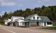
Sheenboro
Sheenboro is a village and municipality in the Outaouais region, part of the Pontiac Regional County Municipality, Quebec, Canada. It was formerly known as Sheen-Esher-Aberdeen-et-Malakoff. Its territory stretches along the north shore of the Ottawa River from Chichester to Rapides-des-Joachims.
Sheenboro | |
|---|---|
 | |
 Location within Pontiac RCM | |
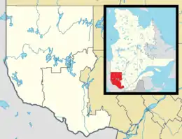 Sheenboro Location in western Quebec | |
| Coordinates: 45°58′N 77°14′W[1] | |
| Country | |
| Province | |
| Region | Outaouais |
| RCM | Pontiac |
| Constituted | January 1, 1869 |
| Government | |
| • Mayor | Doris Ranger |
| • Federal riding | Pontiac |
| • Prov. riding | Pontiac |
| Area | |
| • Total | 634.00 km2 (244.79 sq mi) |
| • Land | 570.92 km2 (220.43 sq mi) |
| Population | |
| • Total | 130 |
| • Density | 0.2/km2 (0.5/sq mi) |
| • Pop 2011-2016 | |
| • Dwellings | 273 |
| Time zone | UTC−5 (EST) |
| • Summer (DST) | UTC−4 (EDT) |
| Postal code(s) | J0X 2Z0 |
| Area code(s) | 819 |
| Highways | No major routes |
Because of its Irish heritage, Sheenboro retained the character of being a Little Corner of Ireland. Primarily dependent on farming and logging, it is also a popular location for tourism, swelling its summer population up to 500 persons. The Fort William Trading Post (now Hotel Pontiac), including the factor's house and church, is a historical site and heritage village with a popular beach in the summer. It is also home to a sacred Algonquin burial ground.[5]
Geography
The municipality is sparsely populated, with its population concentrated in the two communities of Sheenboro and Fort William, and along the Ottawa River, all in the south-eastern part of its territory.[6] The isolated hamlets of Schyan Point, located at the confluence of the Schyan and Ottawa Rivers (almost across from Deep River, Ontario), and Fraser Landing, on the Ottawa River in Malakoff Township, are no more than a handful of seasonally-occupied cabins and have no paved road connection to them.
The remainder of the municipality is undeveloped Canadian Shield wilderness, most of which is part of a controlled exploitation zone. Its rugged terrain rises from about 110 metres (360 ft) above sea level at the hamlet of Fort William to over 180 metres (590 ft) at the village of Sheenboro, reaching 430 metres (1,410 ft) northwest of Trout Lake.[7] Heading north from the hamlet of Schyan Point, the land rises gradually from 121 metres (397 ft) to the peak of Mount Martin at 411 metres (1,348 ft).[8]
Notable lakes within the municipality include Dufoe, Esher, Manny, McCool, McGillivray, L'Oiseau, and Lackey Lakes, and numerous other bodies of water of lesser importance, such as Sheen, McDonald, Trout, Tremblay, and Greer Lakes.[7]
History
In 1823, John Siveright, factor of the Hudson's Bay Company in charge of Fort-Coulonge, sent John McLean upstream to build a post at Lac des Allumettes. The post had to compete with many petty traders, including one who was already on the site. Because the fur trade couldn't cover the post's expenses, a farm was added in the 1830s in order to sell provisions to lumber companies for their camps. At the same time, settlers began to move into the area. By 1844 it was handling the bulk of the Indian trade in the region. Hector McKenzie, in charge from 1845 to 1864, made the post profitable by dealing with lumber companies and settlers. He built an unusually large two-story house which is still standing.[9][10]
In 1848 a post office was established and the name changed from Lac des Allumettes to Fort William in honour of William McGillivray. It was a long-established custom for Indians to come to Lac des Allumettes to meet with Jesuits from Montreal and solemnize baptisms and marriages. Following this, a great feast was held. In 1857, the HBC built an Indian church. Due to freight costs, competition, and the advent of steam transportation, the HBC sold Fort William in 1869 for $3000 and moved its operations to Pembroke, Ontario. The site was on the north bank of the Chenal de la Culbute north of Allumette Island.[9][10]
On the Gale and Duberger map of 1795, the Townships of Sheen, Esher, and Hastings are already shown, even though these townships would not be officially established until several decades later.[7][8] Respectively, these townships were probably named after an English village in north Surrey County (now the London Borough of Richmond upon Thames), a residential suburb in south-west London, and the English town of Hastings.[6][11] Hastings Township was renamed to Malakoff in 1856, commemorating the French victory in the Battle of Malakoff.[11]
In the 1830s, Irish people, escaping famine and religious persecution, began to settle in the area and in 1848, a post office was opened in Fort William.[5] In 1849, the Township of Sheen was established, and six years later the Township Municipality of Sheen was formed[6] with Thomas Harrington as its first mayor.[5]
In 1869, the townships of Esher, Malakoff, and Aberdeen became part of Sheen, forming the United Township Municipality of Sheen-Esher-Aberdeen-Malakoff. One year later, the Sheenboro post office was opened[6] and a store and hotel was built by Michael Hayes. Shortly after in 1872, the St-Paul-the-Hermit parish church was built after the original church was destroyed by fire.[5]
In 1960, the territory of the former Aberdeen Township was added to Rapides-des-Joachims, but the United Township Municipality retained its full name.[5] In 1968, the post office in Fort William closed.[12]
On October 11, 2003, the name and status of the United Township Municipality of Sheen-Esher-Aberdeen-Malakoff changed to become the Municipality of Sheenboro.[13]
Demographics
| Canada census – Sheenboro community profile | |||
|---|---|---|---|
| 2016 | 2011 | 2006 | |
| Population: | 130 (0% from 2011) | 130 (-22.2% from 2006) | 167 (+45.2% from 2001) |
| Land area: | 570.92 km2 (220.43 sq mi) | 570.70 km2 (220.35 sq mi) | 569.97 km2 (220.07 sq mi) |
| Population density: | 0.2/km2 (0.52/sq mi) | 0.2/km2 (0.52/sq mi) | 0.3/km2 (0.78/sq mi) |
| Median age: | 55.4 (M: 58.5, F: 52.8) | 46.5 (M: 49.7, F: 44.4) | 44.9 (M: 45.8, F: 42.2) |
| Total private dwellings: | 273 | 220 | 214 |
| Median household income: | $64,384 | $.N/A | $.N/A |
| Notes: Income data for this area has been suppressed for data quality or confidentiality reasons. – References: 2016[14] 2011[15] 2006[16] earlier[17] | |||
| Year | Pop. | ±% |
|---|---|---|
| 1986 | 118 | — |
| 1991 | 99 | −16.1% |
| 1996 | 127 | +28.3% |
| 2001 | 115 | −9.4% |
| 2006 | 167 | +45.2% |
| 2011 | 130 | −22.2% |
| 2016 | 130 | +0.0% |
| Source: [18] | ||
Language
| Canada Census Mother Tongue - Sheenboro, Quebec[3][18] | ||||||||||||||||||
|---|---|---|---|---|---|---|---|---|---|---|---|---|---|---|---|---|---|---|
| Census | Total | French |
English |
French & English |
Other | |||||||||||||
| Year | Responses | Count | Trend | Pop % | Count | Trend | Pop % | Count | Trend | Pop % | Count | Trend | Pop % | |||||
2016 |
140 |
15 | 10.7% | 120 | 85.7% | 0 | 0.0% | 5 | 3.6% | |||||||||
2011 |
130 |
5 | 3.8% | 120 | 92.3% | 0 | 0.0% | 5 | 3.8% | |||||||||
2006 |
- |
- | 0.0% | - | 0.0% | - | 0.0% | - | 0.0% | |||||||||
2001 |
0 |
0 | 0.0% | 90 | 0.0% | 0 | 0.0% | 0 | 0.0% | |||||||||
1996 |
125 |
0 | n/a | 0.0% | 110 | n/a | 88.0% | 0 | n/a | 0.0% | 15 | n/a | 12.0% | |||||
| Note: 2006 language data for this area has been suppressed for data quality or confidentiality reasons. | ||||||||||||||||||
Attractions
- Oiseau Rock
- Oiseau Rock is a 150 metres (490 ft) high rock cliff rising from the Ottawa River. It is a historic and sacred site of the Anishinaabe, who used to make tobacco offerings there and paint pictographs, such as images of canoes, arrowheads, fish, serpents, and thunderbirds. Despite damage from graffiti, the many pictographs there are considered to be "the most important and prominent rock-art site in Quebec." The rock has been an attraction since the time when steamboats were the main mode of transportation on the Ottawa River, stopping by the rock to blow the whistle and listen to the echo. Today there is a hiking trail to the top of the rock, providing several lookouts on the way.[19]
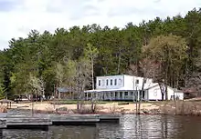
- Fort William/Hotel Pontiac
- Located at a sandy beach on the Ottawa River, the hotel was originally founded in 1823 as a fur trade post by the HBC. In 1869, it was sold to James McCool, who built the Hotel Pontiac in 1896. At one time, it had 60 rooms, hosting guests arriving by steamboat, including silent-film actress Mary Pickford. The hotel offers cabin accommodations and serves meals to beach-goers.[10]
Additionally, Sheenboro is the access point for Zec Saint-Patrice, a wilderness zone for hunting and fishing.
Local government
List of former mayors:
- Roy Perrault (2003–2009)
- Dick Edwards (2009–2013)
- Shamus Morris (2013–2014)
- Doris Ranger (2014–present)
See also
References
- Reference number 378450 of the Commission de toponymie du Québec (in French)
- "Sheenboro". Répertoire des municipalités (in French). Ministère des Affaires municipales, des Régions et de l'Occupation du territoire. Retrieved 2012-04-02.
- "(Code 2484095) Census Profile". 2016 census. Statistics Canada. 2017.
- "Population and dwelling count amendments, 2016 Census". www12.statcan.gc.ca. Government of Canada - Statistics Canada. Retrieved 22 November 2019.
- "History of Sheenboro". Sheenboro CAP Site. Archived from the original on February 17, 2007. Retrieved 2008-04-15.
- "Municipalité de Sheenboro" (in French). Commission de toponymie du Québec. Retrieved 2008-04-14.
- "Canton de Sheen" (in French). Commission de toponymie du Québec. Retrieved 2008-04-14.
- "Canton d'Esher" (in French). Commission de toponymie du Québec. Retrieved 2008-04-14.
- Elizabeth Browne Losey (1999). Let Them be Remembered: The Story of the Fur Trade Forts (1st ed.). Vantage Press. ISBN 9780533125722.
- "Fort William". www.sheenboro.ca. Municipality of Sheenboro. Retrieved 25 November 2019.
- "Canton de Malakoff" (in French). Commission de toponymie du Québec. Retrieved 2008-04-14.
- "Fort William" (in French). Commission de toponymie du Québec. Retrieved 2008-04-14.
- "Sheen-Esher-Aberdeen-et-Malakoff" (in French). Commission de toponymie du Québec. Retrieved 2008-04-14.
- "2016 Community Profiles". 2016 Canadian Census. Statistics Canada. February 21, 2017. Retrieved 2019-11-22.
- "2011 Community Profiles". 2011 Canadian Census. Statistics Canada. July 5, 2013. Retrieved 2012-04-02.
- "2006 Community Profiles". 2006 Canadian Census. Statistics Canada. March 30, 2011. Retrieved 2012-04-02.
- "2001 Community Profiles". 2001 Canadian Census. Statistics Canada. February 17, 2012.
- Statistics Canada: 1996, 2001, 2006, 2011 census
- "Oiseau Rock". www.sheenboro.ca. Municipality of Sheenboro. Retrieved 25 November 2019.
External links
| Wikimedia Commons has media related to Sheenboro. |
Adjacent Municipal Subdivisions | |
|---|---|
| Municipalities | |
|---|---|
| Townships | |
| Villages | |
| Unorganized territories | |
| |
| Authority control |
|---|