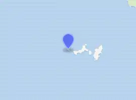
Shillay, Monach Islands
Shillay (Scottish Gaelic: Siolaigh or Seilaigh from the Norse selrey, meaning Seal island) is the westernmost of the Monach Islands (Heisgeir), off North Uist in the Outer Hebrides.
| Scottish Gaelic name | Siolaigh/Seilaigh |
|---|---|
| Old Norse name | Selrey |
| Meaning of name | Seal Island or "Herring island", from Norse |
| Location | |
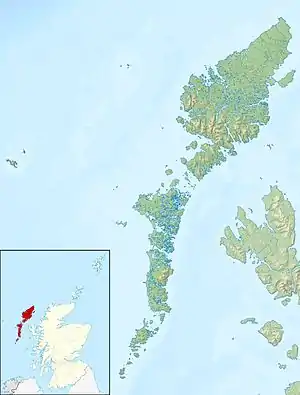 Shillay Shillay shown within the Outer Hebrides | |
| OS grid reference | NF593628 |
| Coordinates | 57.53°N 7.69°W |
| Physical geography | |
| Island group | Monach Islands |
| Area | 7.4 ha |
| Highest elevation | 10 m (33 ft) |
| Administration | |
| Sovereign state | United Kingdom |
| Country | Scotland |
| Council area | Comhairle nan Eilean Siar |
| Demographics | |
| Population | 0 |
| References | [1][2][3][4] |
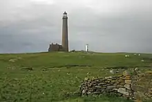 The old lighthouse was not used between 1942 and 2008 | |
| |
| Location | Shillay Isle Monach Islands Outer Hebrides Scotland United Kingdom |
|---|---|
| Coordinates | 57.525894°N 7.695055°W |
| Year first constructed | 1864 |
| Deactivated | 1942-2008 |
| Construction | brick tower |
| Tower shape | tapered cylindrical tower with balcony and lantern attached to a 2-storey keeper’s house |
| Markings / pattern | unpainted tower |
| Tower height | 41 metres (135 ft) |
| Focal height | 47 metres (154 ft) |
| Range | 18 nautical miles (33 km; 21 mi) |
| Characteristic | Fl (2) W 15s. |
| Admiralty number | A4020.5 |
| NGA number | 3955 |
| ARLHS number | SCO-137 |
| Managing agent | Northern Lighthouse Board [5][6] |
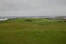
Geology and geography
Like most of the other Monach Islands, Shillay has a thin, sandy soil, which has been much troubled by erosion, and which was badly eroded by a huge wave in the 16th century.
Despite Ceann Iar's name, meaning "western headland", Shillay is the westernmost island of the group.
There are several small islets around Shillay, including Eilean Siorraidh, Odarum (to the north) and Raisgeir.
Lighthouse
The lighthouse at Shillay has an uneven history. The red brick lighthouse was built in 1864 by David & Thomas Stevenson, and was in use until it was closed during the war in 1942 and not lit again in 1948 after hostilities ceased. After the Braer disaster in 1993 in Shetland, a new light was recommended to mark the deep water route west of the Hebrides. A new automated aluminium light was installed in 1997. However it proved inadequate and in 2005 it was decided that it was cheaper to reuse the original lighthouse than to increase the height of the new light. In 2008 the old lighthouse was refurbished and put back into use.[7][8]
A stone from the lighthouse has been removed into the church wall at Paible; a keeper had carved into it "Eternity Oh Eternity".[2] Just to the south of Shillay, there is an Eilean Siorraidh ("Island of Eternity"; formerly Eilean Siorruidh) - whether this carving is a reference to this or the solitude of the island is unrecorded.
References
- 2001 UK Census per List of islands of Scotland
- Haswell-Smith, Hamish (2004). The Scottish Islands. Edinburgh: Canongate. ISBN 978-1-84195-454-7.
- Ordnance Survey
- Iain Mac an Tailleir. "Placenames" (PDF). Pàrlamaid na h-Alba. Archived from the original (PDF) on 29 May 2008. Retrieved 8 December 2007.
- Shillay (Siolaigh, Monach Isles) The Lighthouse Directory. University of North Carolina at Chapel Hill. Retrieved 19 May 2016
- Monach Northern Lighthouse Board. Retrieved 19 May 2016
- "Monach Light". Northern Lighthouse Board. Retrieved 21 June 2015.
- https://www.bbc.co.uk/iplayer/episode/b00y6hym/The_Lighthouse_Stevensons/%5B%5D