Holy Island, Firth of Clyde
The Holy Island or Holy Isle (Scottish Gaelic: Eilean MoLaise) is an island in the Firth of Clyde, off the west coast of central Scotland, inside Lamlash Bay on the larger Isle of Arran. The island is around 3 kilometres (1 7⁄8 mi) long and around 1 kilometre (5⁄8 mi) wide. Its highest point is the hill Mullach Mòr.
| Scottish Gaelic name | An t-Eilean Àrd or Eilean MoLaise |
|---|---|
| Meaning of name | "the high island" or "Laisren's island" in Gaelic. |
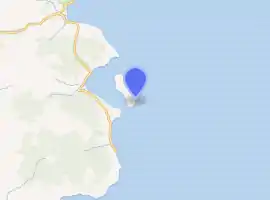
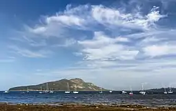 Holy Island from Lamlash | |
| Location | |
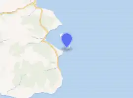
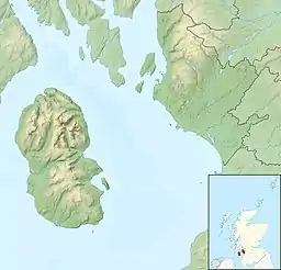 Holy Island Holy Island shown within North Ayrshire | |
| OS grid reference | NS063297 |
| Coordinates | 55.53°N 5.07°W |
| Physical geography | |
| Island group | Firth of Clyde |
| Area | 253 ha (1 sq mi) |
| Area rank | 95 [1] |
| Highest elevation | Mullach Mòr, 1,030 ft (314 m) – a Marilyn |
| Administration | |
| Sovereign state | United Kingdom |
| Country | Scotland |
| Council area | North Ayrshire |
| Demographics | |
| Population | 31[2] |
| Population rank | 58 [1] |
| Population density | 12/km2 (31/sq mi)[2][3] |
| References | [3][4] [5] |
| Mullach Mòr | |
|---|---|
| Highest point | |
| Elevation | 1,030 ft (310 m) |
| Prominence | 1,030 ft (310 m) |
| Listing | Marilyn |
| Coordinates | 55°31′30″N 5°04′20″W |
| Naming | |
| English translation | Big hill |
| Language of name | Gaelic |
| Pronunciation | Scottish Gaelic: [ˈmul̪ˠəx ˈmoːɾ] |
| Geography | |
| Location | Firth of Clyde, Scotland |
| OS grid | NS063297 |
| Topo map | OS Landranger 69 |
 Holy Isle Outer Lighthouse | |
 Scotland | |
| |
| Location | Holy Island Isle of Arran North Ayrshire Scotland United Kingdom |
|---|---|
| Coordinates | 55.517299°N 5.060764°W |
| Year first constructed | 1905 |
| Automated | 1977[6] |
| Construction | masonry tower |
| Tower shape | quadrangular tower with balcony and lantern |
| Markings / pattern | white tower, black lanter, ochre trim |
| Tower height | 23 metres (75 ft) |
| Focal height | 38 metres (125 ft) |
| Light source | solar power |
| Range | 25 nautical miles (46 km; 29 mi)[7] |
| Characteristic | Fl (2) W 20s. |
| Admiralty number | A4330 |
| NGA number | 4320 |
| ARLHS number | SCO-100 |
| Managing agent | Samyé Ling Buddhist Community [8] |
 Holy Isle Inner Lighthouse | |
| |
| Location | Holy Island Isle of Arran North Ayrshire Scotland United Kingdom |
|---|---|
| Coordinates | 55.512218°N 5.070168°W |
| Year first constructed | 1877 |
| Automated | 1977[6] |
| Construction | masonry tower |
| Tower shape | cylindrical tower with balcony and lantern |
| Markings / pattern | white tower, black lanter, ochre trim |
| Tower height | 14 metres (46 ft) |
| Focal height | 17 metres (56 ft) |
| Light source | solar power |
| Characteristic | Fl G 3s. |
| Admiralty number | A4332 |
| NGA number | 4328 |
| ARLHS number | SCO-101 |
| Managing agent | Samyé Ling Buddhist Community [9] |
History
The island has a long history as a sacred site, with a spring or holy well held to have healing properties, the hermit cave of 6th century monk St Molaise, and evidence of a 13th-century monastery. An old Gaelic name for the island was Eilean MoLaise, Molaise's Island; this is the origin (via Elmolaise and Limolas) of "Lamlash", the name of the village on Arran that faces Holy Island.
Some runic writing is to be found on the roof of St Molaise's cave and a Viking fleet sheltered between Arran and Holy Isle before the Battle of Largs.
In 1549, Dean Monro wrote of the "little ile callit the yle of Molass, quherin there was foundit by Johne, Lord of the iles, ane monastry of friars, which is decayit."[10]
Present day
In 1992, the island was in the possession of Kay Morris, a devout Catholic who reportedly had a dream in which the Virgin Mary instructed her to give ownership of the island to the Samyé Ling Buddhist Community, who belong to the Kagyu school of Tibetan Buddhism.[11] The settlements on the island include the Centre for World Peace and Health, founded by Lama Yeshe Losal Rinpoche, on the north of the island. This is an environmentally designed residential centre for courses and retreats which extends the former farm house. It has solar water heating and a reed-bed sewage treatment system. The approach from the ferry jetty is decorated with Tibetan flags and stupas. On the southern end of the island lives a community of nuns who are undertaking three year retreats.
The remainder of the island is treated as a nature reserve with wild Eriskay ponies, Saanen goats, Soay sheep and the replanting of native trees. The rare Rock Whitebeam tree is found on the island, an essential link in the evolution of the Arran Whitebeam species, Sorbus arranensis, Sorbus pseudofennica and Sorbus pseudomeinichii. These are indigenous and unique to Arran.
There is a regular ferry service from Lamlash, and the island is popular with holiday makers staying on Arran. The usually resident population was recorded as 31 in 2011,[2] an increase from 13 in 2001.[12]
Gallery
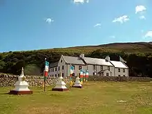 The Centre for World Peace and Health, with Tibetan flags and stupas
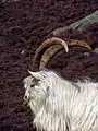 One of the Saanen goats
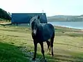 One of the wild Eriskay ponies
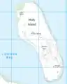 Map of the island
References
- Area and population ranks: there are c. 300 islands over 20 ha in extent and 93 permanently inhabited islands were listed in the 2011 census.
- National Records of Scotland (15 August 2013). "Appendix 2: Population and households on Scotland's Inhabited Islands" (PDF). Statistical Bulletin: 2011 Census: First Results on Population and Household Estimates for Scotland Release 1C (Part Two) (PDF) (Report). SG/2013/126. Retrieved 14 August 2020.
- Haswell-Smith, Hamish (2004). The Scottish Islands. Edinburgh: Canongate. ISBN 978-1-84195-454-7.
- Ordnance Survey: Landranger map sheet 69 Isle of Arran (Map). Ordnance Survey. 2014. ISBN 9780319229644.
- Mac an Tàilleir, Iain (2003) Ainmean-àite/Placenames. (pdf) Pàrlamaid na h-Alba. Retrieved 26 August 2012.
- Lighthouses holyisland.org
- Holy Island Outer Light Lighthouse Explorer
- Holy Isle Outer (Pillar Rock) The Lighthouse Directory. University of North Carolina at Chapel Hill. Retrieved 15 May 2016
- Holy Isle Inner (Lamlash) The Lighthouse Directory. University of North Carolina at Chapel Hill. Retrieved 15 May 2016
- Monro (1549) "Molass" no. 5
- Holy Isle Buddhists fight power plant by Martin McLaughlin The Scotsman 29 July 2019
- General Register Office for Scotland (28 November 2003) Scotland's Census 2001 – Occasional Paper No 10: Statistics for Inhabited Islands. Retrieved 26 February 2012.
- Monro, Sir Donald (1549) Description of the Western Isles of Scotland. William Auld. Edinburgh - 1774 edition.
External links
 Holy Island travel guide from Wikivoyage
- The Holy Island Project web site
- Movie of images taken on the island
- Photo Tour of a hike across the Holy Isle
| Wikimedia Commons has media related to Holy Island, Firth of Clyde. |
| Main villages | 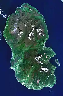 | |
|---|---|---|
| Smaller villages and settlements | ||
| Mountains and hills | ||
| History |
| |
| Environment | ||
| Economy | ||
| Surrounding islands |
| |
|  | ||||||||||||||||
|
| |||||||||||||||||
| |||||||||||||||||
| |||||||||||||||||
| |||||||||||||||||
| |||||||||||||||||
| |||||||||||||||||
| |||||||||||||||||