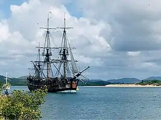
Slade Point, Queensland
Slade Point is a coastal town and peninsular suburb of Mackay in the Mackay Region, Queensland, Australia.[2][3]
| Slade Point Mackay, Queensland | |||||||||||||||
|---|---|---|---|---|---|---|---|---|---|---|---|---|---|---|---|
 Aerial view of Slade Point, 2005 | |||||||||||||||
 Slade Point | |||||||||||||||
| Coordinates | 21.0711°S 149.2236°E | ||||||||||||||
| Population | 3,349 (2016 census)[1] | ||||||||||||||
| • Density | 434.9/km2 (1,126/sq mi) | ||||||||||||||
| Postcode(s) | 4740 | ||||||||||||||
| Area | 7.7 km2 (3.0 sq mi) | ||||||||||||||
| LGA(s) | Mackay Region | ||||||||||||||
| State electorate(s) | Mackay | ||||||||||||||
| Federal Division(s) | Dawson | ||||||||||||||
| |||||||||||||||
History
The first British people to visit the area were the crew and passengers aboard the ketch Presto which pulled into the bay at Slade Point in June 1862 after having difficulty entering the Pioneer River.[4] A passenger named Roberts was surrounded by some of the resident Aboriginal population and taken away. Armed crew-members formed a search party but were unable to locate him. Another larger search party, assisted by troopers of the Native Police, was later organised but no trace of Roberts was found.[5][6]
Originally, the town was called Amhurst but it was renamed on 1 January 1967 to be Slade Point, named after the prominent headland of the same name which named in June 1770 by Lieutenant James Cook of HMS Endeavour, after Thomas Slade, Surveyor of the Royal Navy and designer of Horatio Nelson's ship HMS Victory.[2][3][7]
Amhurst State School opened on 11 April 1939. It was renamed Slade Point State School in 1967.[8]
Amenities
The Mackay Regional Council operates a mobile library service on a fortnightly schedule at Pheasant Street.[9][10]
Education
Slade Point State School is a government primary (P-6) school for boys and girls at 362 Slade Point Road. In 2017, the school had an enrolment of 110 students with 13 teacher (11 full-time equivalent) and 11 non-teaching staff (8 full-time equivalent).[11]
References
- Australian Bureau of Statistics (27 June 2017). "Slade Point (State Suburb)". 2016 Census QuickStats. Retrieved 18 April 2018.

- "Slade Point – town (entry 31105)". Queensland Place Names. Queensland Government. Retrieved 23 April 2017.
- "Slade Point – locality (entry 46839)". Queensland Place Names. Queensland Government. Retrieved 23 April 2017.
- Roth, H. Ling (1908), The discovery and settlement of Port Mackay, Queensland with numerous illustrations, charts and maps, and some notes on the natural history of the district, Halifax, Eng F. King & sons, Ltd, retrieved 31 October 2020
- "ROCKHAMPTON". Maryborough Chronicle, Wide Bay And Burnett Advertiser. II (83). Queensland, Australia. 19 June 1862. p. 2. Retrieved 31 October 2020 – via National Library of Australia.
- "None". Rockhampton Bulletin And Central Queensland Advertiser (58). Queensland, Australia. 19 July 1862. p. 2. Retrieved 31 October 2020 – via National Library of Australia.
- "Slade Point – point in Mackay Region (entry 46839)". Queensland Place Names. Queensland Government. Retrieved 19 October 2018.
- Queensland Family History Society (2010), Queensland schools past and present (Version 1.01 ed.), Queensland Family History Society, ISBN 978-1-921171-26-0
- "Libraries: Contact/Opening Hours". Mackay Regional Council. Retrieved 28 April 2017.
- "Mobile Library Timetable 2017" (PDF). Mackay Regional Council. Retrieved 8 May 2017.
- "Annual Report 2017". Slade Point State School. Retrieved 19 October 2018.
External links
| Wikimedia Commons has media related to Slade Point, Queensland. |
- "Slade Point". Queensland Places. Centre for the Government of Queensland, University of Queensland.
