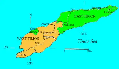
Soe, Timor
Soe (sometimes seen as SoE) is the administrative capital of the South Central Timor Regency, in East Nusa Tenggara province of Indonesia. Soe is located on Timor Island.
Soe | |
|---|---|
 Soe Location in Indonesia  Soe Soe (Indonesia) | |
| Coordinates: | |
| Country | Indonesia |
| Region | Lesser Sunda Islands |
| Province | East Nusa Tenggara |
| Territory | West Timor |
| Regency | South Central Timor |
| Area | |
| • Total | 10.84 sq mi (28.08 km2) |
| Elevation | 2,600 ft (800 m) |
| Population (2020) | |
| • Total | 41,402 |
| [1] | |
| Time zone | UTC+8 (CIT) |
It was heavily bombed in 1944 during the second world war [2][3]
Water supplies for the locality have been a problem for a considerable time, despite aid to assist with dams and other means of finding water [4]
The town has an officially estimated 41,402 inhabitants in 2020.[5]</ref>
Soe can be a base for tourists for trips to other locations. Oinlasi, Boti, Niki Niki and Kapan are reachable from Soe.
It is on the route (via Kapan) to the highest mountain in West Timor Mount Mutis.
| Wikimedia Commons has media related to Soe (Indonesia). |
References
- Badan Pusat Statistik, Jakarta, 2020.
- "ATTACK ON TIMOR". Kalgoorlie Miner (WA : 1895 - 1950). WA: National Library of Australia. 18 April 1944. p. 2. Retrieved 17 January 2014.
- "ENEMY AIRSTRIPS". Kalgoorlie Miner (WA : 1895 - 1950). WA: National Library of Australia. 12 September 1944. p. 2. Retrieved 17 January 2014.
- Hehanussa, P. E (1984), Sumberdaya air di daerah Soe, Timor tengah bagian selatan, Lembaga Geologi dan Pertambangan Nasional, Lembaga Ilmu Pengetahuan Indonesia, 1984, retrieved 17 January 2014
- Badan Pusat Statistik, Jakarta, 2020.
This article is issued from Wikipedia. The text is licensed under Creative Commons - Attribution - Sharealike. Additional terms may apply for the media files.
