Timor
Timor is an island at the southern end of Maritime Southeast Asia, in the north of the Timor Sea. The island is divided between the sovereign states of East Timor on the eastern part and Indonesia on the western part. The Indonesian part, also known as West Timor, constitutes part of the province of East Nusa Tenggara. Within West Timor lies an exclave of East Timor called Oecusse District. The island covers an area of 30,777 square kilometres (11,883 square miles). The name is a variant of timur, Malay for "east"; it is so called because it lies at the eastern end of the Lesser Sunda Islands. Mainland Australia is less than 500 km away, separated by the Timor Sea.
 Timor as seen from space in 1989 | |
 Top: Political division of Timor between Indonesia and East Timor Bottom: Location of Timor in Indonesia | |
 Timor | |
| Geography | |
|---|---|
| Location | South East Asia |
| Coordinates | 9°14′S 124°56′E |
| Area | 30,777 km2 (11,883 sq mi) |
| Area rank | 44th |
| Highest elevation | 2,963 m (9,720 ft) |
| Highest point | Ramelau |
| Administration | |
| Largest settlement | Dili (pop. 222,323 as of 2015) |
| Province | |
| Largest settlement | Kupang (West Timor) (pop. 434,972 as of 2019) |
| Demographics | |
| Population | 3,182,693 (2014) |
| Pop. density | 94.5/km2 (244.8/sq mi) |
Language, ethnic groups and religion
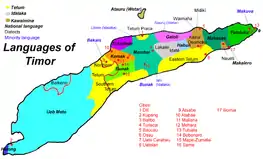
Anthropologists identify eleven distinct ethno-linguistic groups in Timor. The largest are the Atoni of western Timor and the Tetum of central and eastern Timor.[1] Most indigenous Timorese languages belong to the Timor–Babar branch of the Austronesian languages spoken throughout the Indonesian archipelago. Although lexical evidence is lacking,[2] the non-Austronesian languages of Timor are thought to be related to languages spoken on Halmahera and in Western New Guinea.[1] Some are so mixed that it is difficult to tell which family they descend from.
The official languages of East Timor are Tetum and Portuguese, while in West Timor it is Indonesian. Indonesian, a standardized dialect of Malay, is also widely spoken and understood in East Timor.[3]
Christianity is the dominant religion throughout the island of Timor, at about 90% of the population. However, it is unequally distributed as West Timor is 58% Protestant and 37% Catholic, and East Timor is 98% Catholic and 1% Protestant. Islam and animism make up most of the remainder at about 5% each across the island.
Geography
Timor is located north of Australia, and is one of the easternmost Sunda Islands. Together with Sumba, Babar and associated smaller islands, Timor forms the southern outer archipelago of the Lesser Sunda Islands with the inner islands of Flores, Alor and Wetar to the north, and beyond them Sulawesi.
Timor is the principal island of the Outer Banda Arc, which has been upthrust by collision with the Australian continent. Timor has older geology and lacks the volcanic nature of the northern Lesser Sunda Islands. The orientation of the main axis of the island also differs from its neighbors. These features have been explained as the result of being on the northern edge of the Indo-Australian Plate as it meets the Eurasian Plate and pushes into South East Asia.[4] The climate includes a long dry season with hot winds blowing over from Australia. Rivers on the island include the Southern and Northern Laclo Rivers in East Timor.
The largest towns on the island are the provincial capital of Kupang in West Timor, Indonesia and the Portuguese colonial towns of Dili the capital, and Baucau in East Timor. Poor roads make transport to inland areas difficult, especially in East Timor.[5] East Timor is a poor country, with health issues including malaria and dengue fever. Sources of revenue include gas and oil in the Timor Sea, coffee growing and tourism.
Administration
| Name | Capital | Area (km2) | Population 2018 Census[6][7] | HDI[8][9] | GDP per capita US$[10] | GDP per capita PPP US$[10][11] | Country |
|---|---|---|---|---|---|---|---|
| Kupang Regency | Kupang | 5,898 | 387,479 | 0.644 (Medium) | 1,407 | 4,625 | |
| South Central Timor Regency | Soe | 3,947 | 465,970 | 0.622 (Medium) | 1,204 | 3,958 | |
| North Central Timor Regency | Kefamenanu | 2,669 | 251,993 | 0.633 (Medium) | 1,146 | 3,767 | |
| Belu Regency | Atambua | 1,284 | 216,783 | 0.625 (Medium) | 1,462 | 4,806 | |
| Malaka Regency | Betun | 1,160 | 189,220 | 0.603 (Medium) | 1,036 | 3,406 | |
| Kupang City | Kupang | 160 | 423,800 | 0.796 (High) | 4,098 | 13,471 | |
| West Timor | Kupang | 15,120 | 1,935,245 | 0.664 (Medium) | 1,884 | 6,193 | |
| Lautém | Lospalos | 1,813 | 64,135 | 0.605 (Medium) | |||
| Baucau | Baucau | 1,506 | 124,061 | 0.603 (Medium) | |||
| Viqueque | Viqueque | 1,877 | 77,402 | 0.604 (Medium) | |||
| Manatuto | Manatuto | 1,782 | 45,541 | 0.616 (Medium) | |||
| Dili | Dili | 367 | 252,884 | 0.728 (High) | |||
| Aileu | Aileu | 737 | 48,554 | 0.613 (Medium) | |||
| Manufahi | Same | 1,323 | 52,246 | 0.618 (Medium) | |||
| Liquiçá | Liquiçá | 549 | 73,027 | 0.632 (Medium) | |||
| Ermera | Gleno | 768 | 127,283 | 0.563 (Low) | |||
| Ainaro | Ainaro | 804 | 66,397 | 0.566 (Low) | |||
| Bobonaro | Maliana | 1,376 | 98,932 | 0.603 (Medium) | |||
| Covalima | Suai | 1,203 | 4,550 | 0.615 (Medium) | |||
| Oecusse (SAR) | Pante Macassar | 814 | 72,230 | 0.565 (Low) | |||
| East Timor | Dili | 15,007 | 1,183,643 | 0.626 (Medium) | 1,294 | 3,252 | |
| Timor | – | 30,777 | 3,118,888 | 0.645 (Medium) | 1,589 | 4,722 |
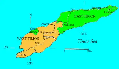
West Timor
West Timor is part of the East Nusa Tenggara province. It was formerly split into the City of Kupang (a kabupaten or regency-level administrative area) and four regencies (kabupaten); from west to east these are: Kupang, Timor Tengah Selatan (South Central Timor), Timor Tengah Utara (North Central Timor) and Belu. However, a fifth regency – Malaka – was in 2012 formed from the southern half of Belu Regency. Note that the administrative area has shrunk as Rote Ndao Regency (Rote and Ndoa islands to the southwest) and Sabu Raijua Regency (the Savu Islands further west) were split off in 2002 and 2009 respectively from Kupang Regency. The island accounts for 35.5% of the provincial population.
Flora and fauna
Timor and its offshore islands such as Atauro, a former place of exile increasingly known for its beaches and coral, as well as Jaco along with Wetar and the other Barat Daya Islands to the northeast constitute the Timor and Wetar deciduous forests ecoregion. The natural vegetation was tropical dry broadleaf forests with an undergrowth of shrubs and grasses supporting a rich wildlife. However much of the original forest has been cleared for farming, especially on the coasts of Timor and on the smaller islands like Atauro. Apart from one large block in the centre of Timor only patches remain. This ecoregion is part of the Wallacea area with a mixture of plants and animals of Asian and Australasian origin; it lies in the western part of Wallacea, in which Asian species predominate.
Many trees are deciduous or partly deciduous, dropping their leaves during the dry season, there are also evergreen and thorn trees in the woodland. Typical trees of the lowland slopes include Sterculia foetida, Calophyllum teysmannii and Aleurites moluccanus.
During the Pleistocene epoch, Timor was the abode of extinct giant monitor lizards similar to the Komodo dragon. Like Flores, Sumba and Sulawesi, Timor was also once a habitat of extinct dwarf stegodonts, relatives of elephants.
Fauna of today includes a number of endemic species such as the distinctive Timor shrew and Timor rat. The northern common cuscus, a marsupial of Australasian origin occurs as well, but is thought to be introduced.[14] The island have a great number of birds, mainly of Asian origin with some of Australasian origin. There is a total of 250 species of which twenty four are endemic, due to the relative isolation of Timor, including five threatened species; the slaty cuckoo-dove, Wetar ground dove, Timor green pigeon, Timor imperial pigeon, and iris lorikeet.[15]
Saltwater crocodiles are found in the wetlands whereas reticulated pythons can be found in forests and grasslands of Timor. However, the population sizes and status are unknown.
Frog species in Timor include Duttaphrynus melanostictus, Hoplobatrachus tigerinus, Limnonectes timorensis, Litoria everetti, and Polypedates leucomystax.[16] A new species of microlyhid frog belonging to the genus Kaloula has also recently been discovered in Timor.[17]
Late Cretaceous fossils of marine vertebrates are known from East Timor deposits. These include mosasaurs such as Globidens timorensis, lamniforme sharks, coelacanths and the choristodere Champsosaurus.[18]
History


The earliest historical record about Timor island is the 14th-century Nagarakretagama, Canto 14, that identifies Timur as an island within Majapahit's realm. Timor was incorporated into ancient Javanese, Chinese and Indian trading networks of the 14th century as an exporter of aromatic sandalwood, slaves, honey and wax, and was settled by both the Portuguese, in the end of the 16th century, and the Dutch, based in Kupang, in the mid-17th century.
As the nearest island with a European settlement at the time, Timor was the destination of William Bligh and seamen loyal to him following the infamous Mutiny on the Bounty in 1789. It was also where survivors of the wrecked HMS Pandora, sent to arrest the Bounty mutineers, landed in 1791 after that ship sank in the Great Barrier Reef.
The island has been politically divided in two parts for centuries. The Dutch and Portuguese fought for control of the island until it was divided by treaty in 1859, but they still did not formally resolve the matter of the boundary until 1912. West Timor, was known as Dutch Timor until 1949 when it became Indonesian Timor, a part of the nation of Indonesia which was formed from the old Netherlands East Indies; while East Timor was known as Portuguese Timor, a Portuguese colony until 1975. It includes the exclave of Oecussi-Ambeno in West Timor.
Japanese forces occupied the whole island from 1942 to 1945. They were resisted in a guerrilla campaign led initially by Australian commandos.
Following the military coup in Portugal in 1974 the Portuguese began to withdraw from Timor, the subsequent internal unrest and fear of the communist Fretilin party led to an invasion by Indonesia, who opposed the concept of an independent East Timor. In 1975, East Timor was annexed by Indonesia and became known as Timor Timur or 'Tim-Tim' for short. It was regarded by Indonesia as the country's 27th province, but this was never recognised by the United Nations (UN) or Portugal.
The people of East Timor, through Falintil the military wing of Fretilin, resisted 35,000 Indonesian troops in a prolonged guerrilla campaign, but the whole island remained under Indonesian control until a referendum held in 1999 under a UN-sponsored agreement between Indonesia and Portugal in which its people rejected the offer of autonomy within Indonesia. The UN then temporarily governed East Timor until it became independent as Timor-Leste in 2002 under the presidency of Falintil leader Xanana Gusmão. Although political strife continued as the new nation coped with poverty the UN presence was much reduced.
A group of people on the Indonesian side of Timor have been reported active since 2001 trying to establish a Great Timor state.[19] However, there is no real evidence that the people of West Timor, most of whom are ethnically Atoni, the traditional enemy of the East Timorese, have any interest in such a union. Furthermore, the current government of East Timor recognizes the existing boundary.
See also
References
- Taylor, Jean Gelman (2003). Indonesia: Peoples and Histories. New Haven and London: Yale University Press. pp. 378. ISBN 978-0-300-10518-6.
- Gary Holton; Laura C. Robinson (2014). "The linguistic position of the Timor-Alor-Pantar languages". In Klamer, Marian (ed.). The Alor-Pantar languages.
- Uri Tadmor (2008). "Grammatical borrowing in Indonesian". In Yaron Matras; Jeanette Sakel (eds.). Grammatical Borrowing in Cross-Linguistic Perspective. Walter de Gruyter. p. 301. ISBN 978-3-11-019919-2.
- Audley-Charles, M.G. (1987) "Dispersal of Gondwanaland: relevance to evolution of the Angiosperms" In: Whitmore, T.C. (ed.) (1987) Biogeographical Evolution of the Malay Archipelago Oxford Monographs on Biogeography 4, Clarendon Press, Oxford, pp. 5–25, ISBN 0-19-854185-6
- Kusago, Takayoshi (2005). "Post-Conflict Pro-Poor Private-Sector Development: The Case of Timor-Leste". Development in Practice. 15 (3/4): 502–513. doi:10.1080/09614520500075995. JSTOR 4029980. S2CID 55022366.
- Badan Pusat Statistik NTT (2020). Jumlah Penduduk Menurut Kelompok Umur dan Kabupaten/Kota di Provinsi Nusa Tenggara Timur, 2018. Kupang: Badan Pusat Statistik.
- Jornal da República: Diploma Ministerial no. 24/2014 de 24 de Julho, Orgânica dos Postos Administrativos
- Badan Pusat Statistik NTT (2020). Indeks Pembangunan Manusia (IPM) Menurut Kabupaten/Kota Provinsi Nusa Tenggara Timur, 2010-2019. Kupang: Badan Pusat Statistik.
- "Sub-national Human Development Index by Province, 1990-2018 (New Method)". Retrieved 26 March 2020.
- Badan Pusat Statistik NTT (2020). Produk Domestik Regional Bruto (PDRB) Atas Dasar Harga Berlaku (ADHB) Menurut Kabupaten/Kota di Provinsi Nusa Tenggara Timur (Miliar Rupiah), 2012-2019. Kupang: Badan Pusat Statistik.
- "GDP per capita, PPP (current international $) - Timor-Leste". data.worldbank.org. World Bank. Retrieved 7 July 2020.
- "Diploma Ministerial No:199/GM/MAEOT/IX/09 de 15 de Setembro de 2009 Que fixa o número de Sucos e Aldeias em Território Nacional Exposição de motivos" (PDF), Jornal da Républica, Série I, N.° 33, 16 de Setembro de 2009, 3588-3620, archived from the original (PDF) on 1 March 2012
- Population and Housing Census 2015, Preliminary Results (PDF), Direcção-Geral de Estatística, retrieved 15 January 2018
- IUCN Red List: Northern Common Cuscus accessed 17 June 2010
- "Timor and Wetar deciduous forests". Terrestrial Ecoregions. World Wildlife Fund.
- Kaiser H, Ceballos J, Freed P, Heacox S, Lester B, Richards S, Trainor C, Sanchez C, O’Shea M (2011) The herpetofauna of Timor-Leste: a first report. ZooKeys 109: 19-86. https://doi.org/10.3897/zookeys.109.1439
- O'Shea, Marc and Sanchez, Caitlin. 2015. Herpetological Diversity of Timor-Leste: Updates and a Review of Species Distributions. Asian Herpetological Research, 6(2): 73-131. https://doi.org/10.16373/j.cnki.ahr.140066
- J. H. F. Umbgrove, Structural History of the East Indies
- etan.org
External links
 The dictionary definition of timor at Wiktionary
 Timor travel guide from Wikivoyage
 Media related to Timor at Wikimedia Commons
