Sokoto State
Sokoto, generally referred to as Sokoto State to distinguish it from city of Sokoto, its capital and largest city, is a state in the extreme northwest of Nigeria. Sokoto is located near to the confluence of the Sokoto River and the Rima River. As of 2005 it has an estimated population of more than 4.2 million.
Sokoto State | |
|---|---|
 | |
| Nickname(s): Seat of the Caliphate | |
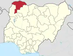 Location of Sokoto State in Nigeria | |
| Coordinates: 13°05′N 05°15′E | |
| Country | |
| Date created | 3 February 1976 |
| Capital | Sokoto |
| Government | |
| • Governor (List) | Aminu Waziri Tambuwal (PDP) |
| • Deputy Governor | Munir Daniya |
| • Senators |
|
| Area | |
| • Total | 25,973 km2 (10,028 sq mi) |
| Area rank | 16th of 36 |
| Population (2006 census) | |
| • Total | 3,702,676[1] |
| • Rank | 14th of 36 |
| GDP (PPP) | |
| • Year | 2007 |
| • Total | $4.82 billion[2] |
| • Per capita | $1,274[2] |
| Time zone | UTC+01 (WAT) |
| postal code | 840001 |
| ISO 3166 code | NG-SO |
| HDI (2018) | 0.339[3] low · 36th of 37 |
The name Sokoto (which is the modern/anglicised version of the local name, Sakkwato) is of Arabic origin, representing suk, "market". It is also known as Sakkwato, Birnin Shaihu da Bello or "Sokoto, Capital of Shaihu and Bello").
Being the seat of the former Sokoto Caliphate, the city is predominantly Muslim and an important seat of Islamic learning in Nigeria. The Sultan who heads the caliphate is effectively the spiritual leader of Nigerian Muslims.
History
Since its creation as a state in 1976 (from the bifurcation of the erstwhile North-Western State (Map) into Sokoto and Niger States, Sokoto state has been ruled by governors, most ex-military officers, who succeeded each another at short intervals.
Sokoto, as a region, knows a longer history. During the reign of the Fulani Empire in the 19th century Sokoto was an important Fula state, in addition to being a city, of what was then west central Nigeria.
From ca. 1900, with the British take-over, Sokoto, which then encompassed the entire north-west corner of Nigeria, became a province of the British protectorate of Nigeria. Not long after Gando was added as a sub-province.[4] This double province then covered an area of 90,000 square kilometres (35,000 sq mi) with an estimated population over 500,000. It included the then Zamfara and Argungun, or Kebbi, kingdoms.
The following excerpt from the 1911 Encyclopædia Britannica offers some information from the perspective of the occupying British power:
The province has been organized on the same principle as the other provinces of Northern Nigeria. A British resident of the first class has been placed at Sokoto and assistant residents at other centres. British courts of justice have been established and British governors are quartered in the province. Detachments of civil police are also placed at the principal stations. The country has been assessed under the new system for taxes and is being opened as rapidly as possible for trade. After the establishment of British rule farmers and herdsmen reoccupied districts and the inhabitants of cities flocked back to the land, rebuilding villages which had been deserted for fifty years. Horse breeding and cattle raising form the chief source of wealth in the province. There is some ostrich farming. Except in the sandy areas there is extensive agriculture, including rice and cotton. Special crops are grown in the valleys by irrigation. Weaving, dyeing and tanning are the principal native industries. Fair roads are in process of construction through the province. Trade is increasing and a cash currency has been introduced.
[...]
In 1906 a rising attributed to religious fanaticism occurred near Sokoto in which unfortunately three white officers lost their lives. The emir heartily repudiated the leader of the rising, who claimed to be a Mahdi inspired to drive the white man out of the country. A British force marched against the rebels, who were overthrown with great loss in March 1906. The leader was condemned to death in the emir's court and executed in the market place of Sokoto, and the incident was chiefly interesting for the display of loyalty to the British administration which it evoked on all sides from the native rulers.[4]
In 1967, not long after Nigeria's independence from the British, the region became known as the Northwestern State. This territory was, in 1976, split into Sokoto State and Niger State. Later on, Kebbi State (1991) and Zamfara State (1996) split off from Sokoto State.
Demographics
Sokoto State is mainly populated by Hausa people.[5] Most Sokoto State residents are Sunni Muslims, with a Shia minority; violence between the two groups is uncommon. Over 80% of people living in the state practice agriculture.
Climate
Sokoto State is in the dry Sahel, surrounded by sandy savannah and isolated hills.
With an annual average temperature of 28.3 °C (82.9 °F), Sokoto is, on the whole, a very hot area. However, maximum daytime temperatures are for most of the year generally under 40 °C (104.0 °F) and the dryness makes the heat bearable. The warmest months are February to April when daytime temperatures can exceed 45 °C (113.0 °F). The rainy season is from June to October during which showers are a daily occurrence. The showers rarely last long and are a far cry from the regular torrential rain known in wet tropical regions. From late October to February, during the cold season, the climate is dominated by the Harmattan wind blowing Sahara dust over the land. The dust dims the sunlight thereby lowering temperatures significantly and also leading to the inconvenience of dust everywhere in houses.
The region's lifeline for growing crops is the floodplains of the Sokoto-Rima river system (see Sokoto River), which are covered with rich alluvial soil. For the rest, the general dryness of the region allows for few crops, millet perhaps being the most abundant, complemented by rice, corn, other cereals and beans. Apart from tomatoes few vegetables grow in the region.
Cities and villages
Local Government Areas
Sokoto State consists of twenty-three (23) Local Government Areas. They are:
Sources
- Nigeria [map]. Collins Bartholomew Ltd. 2005. Published by Spectrum books Ltd.
References
- "2006 PHC Priority Tables – NATIONAL POPULATION COMMISSION". population.gov.ng. Retrieved 10 October 2017.
- "C-GIDD (Canback Global Income Distribution Database)". Canback Dangel. Retrieved 20 August 2008.
- "Sub-national HDI - Area Database - Global Data Lab". hdi.globaldatalab.org. Retrieved 13 September 2018.
-
 One or more of the preceding sentences incorporates text from a publication now in the public domain: Shaw, Flora (1911). "Sokoto". In Chisholm, Hugh (ed.). Encyclopædia Britannica. 25 (11th ed.). Cambridge University Press. pp. 353–354.
 - http://www.onlinenigeria.com/map.gif
External links
- www.sokotostate.gov.ng Sokoto State Government Web Site