Solund
Solund is a municipality in the county of Vestland, Norway. It is located in the traditional district of Sogn. Solund is the westernmost island municipality in Norway. Holmebåen on the island of Steinsøy is the westernmost point in all of Norway. Most residents of Solund live on the main islands of Sula and Ytre Sula. The administrative centre of Solund is the village of Hardbakke on Sula island. Some other villages in Solund include Kolgrov on Ytre Sula, Hersvikbygda on Sula, and Losnegard on Losna.
Solund kommune | |
|---|---|
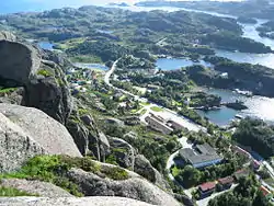 View of Hardbakke | |
 Vestland within Norway | |
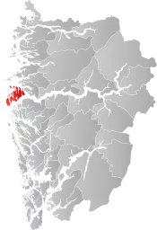 Solund within Vestland | |
| Coordinates: 61°07′51″N 04°56′52″E | |
| Country | Norway |
| County | Vestland |
| District | Sogn |
| Established | 1858 |
| Administrative centre | Hardbakke |
| Government | |
| • Mayor (2015) | Gunn Åmdal Mongstad (Sp) |
| Area | |
| • Total | 228.21 km2 (88.11 sq mi) |
| • Land | 219.10 km2 (84.59 sq mi) |
| • Water | 9.11 km2 (3.52 sq mi) 4% |
| Area rank | 295 in Norway |
| Population (2020) | |
| • Total | 802 |
| • Rank | 345 in Norway |
| • Density | 3.7/km2 (10/sq mi) |
| • Change (10 years) | −7.5% |
| Demonym(s) | Suling[1] |
| Time zone | UTC+01:00 (CET) |
| • Summer (DST) | UTC+02:00 (CEST) |
| ISO 3166 code | NO-4636 |
| Official language form | Nynorsk[2] |
| Website | solund |
The 228-square-kilometre (88 sq mi) municipality is the 295th largest by area out of the 356 municipalities in Norway. Solund is the 345th most populous municipality in Norway with a population of 802. The municipality's population density is 3.7 inhabitants per square kilometre (9.6/sq mi) and its population has decreased by 7.5% over the previous 10-year period.[3][4]
In 2016, the chief of police for Vestlandet formally suggested a reconfiguration of police districts and stations. He proposed that the police station in Solund be closed.[5]
General information
.jpg.webp)
Utvær was established as a municipality in 1858. The two sub-parishes, or sokn, of Solund and Husøy were separated from the Gulen parish (prestegjeld) to form the new municipality and parish of Utvær at that time. The initial population of Utvær was 1,384. On 1 January 1888, the Krakken farm (population: 17) on the extreme northeastern part of Sula island was transferred from Hyllestad Municipality and eight farms in the Hersvikbygda area (population: 317) on northern Sula island were transferred from Askvoll Municipality and they were all added to the municipality of Utvær.
On 1 July 1890, the municipal name of Utvær was changed to Sulen. The spelling was later altered to Solund by royal decree on 16 November 1923. During the 1960s, there were many municipal mergers across Norway due to the work of the Schei Committee. On 1 January 1964, the island of Losna (population: 40) was transferred from Gulen Municipality to Solund.[6][7]
On 1 January 2020, the municipality became part of the newly created Vestland county after Sogn og Fjordane and Hordaland counties were merged.
Name
The name (Old Norse: Sólund or Sólundir which is the plural) originally belonged to the island of Sula. The meaning of the name is unknown. In Old Norse times, the sea between Norway and Scotland was called Sólundirhaf which means "the sea (haf) of Solund." The municipality was named Utvær from 1858 until 1 July 1890 when it was changed to Sulen. The spelling was altered to Solund on 16 November 1923.[6][8]
Coat of arms
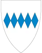
The coat of arms were granted on 16 February 1990. The blue and gray arms have a design of five blue diamonds in a row across the central part of the shield. The arms were inspired by the coat of arms of the now-extinct medieval noble family from the island of Losna.[9]
Churches
The Church of Norway has one parish (sokn) (made up of three churches) within the municipality of Solund. It is part of the Nordhordland prosti (deanery) in the Diocese of Bjørgvin.
| Parish (sokn) | Church name | Location of the church | Year built |
|---|---|---|---|
| Solund | Hersvik Church | Hersvikbygda | 1892 |
| Husøy Church | Kolgrov | 1896 | |
| Solund Church | Hardbakke | 1869 |
Government
All municipalities in Norway, including Solund, are responsible for primary education (through 10th grade), outpatient health services, senior citizen services, unemployment and other social services, zoning, economic development, and municipal roads. The municipality is governed by a municipal council of elected representatives, which in turn elect a mayor.[10] The municipality falls under the Sogn og Fjordane District Court and the Gulating Court of Appeal.
Municipal council
The municipal council (Kommunestyre) of Solund is made up of 15 representatives that are elected to four year terms. The party breakdown of the council is as follows:
| Party Name (in Nynorsk) | Number of representatives | |
|---|---|---|
| Labour Party (Arbeidarpartiet) | 2 | |
| Conservative Party (Høgre) | 4 | |
| Centre Party (Senterpartiet) | 8 | |
| Socialist Left Party (Sosialistisk Venstreparti) | 1 | |
| Total number of members: | 15 | |
| Party Name (in Nynorsk) | Number of representatives | |
|---|---|---|
| Labour Party (Arbeidarpartiet) | 3 | |
| Conservative Party (Høgre) | 5 | |
| Centre Party (Senterpartiet) | 5 | |
| Socialist Left Party (Sosialistisk Venstreparti) | 2 | |
| Total number of members: | 15 | |
| Party Name (in Nynorsk) | Number of representatives | |
|---|---|---|
| Labour Party (Arbeidarpartiet) | 2 | |
| Progress Party (Framstegspartiet) | 2 | |
| Conservative Party (Høgre) | 5 | |
| Centre Party (Senterpartiet) | 4 | |
| Independent Political List in Solund (Politisk Uavhengig Liste i Solund) | 2 | |
| Total number of members: | 15 | |
| Party Name (in Nynorsk) | Number of representatives | |
|---|---|---|
| Labour Party (Arbeidarpartiet) | 3 | |
| Progress Party (Framstegspartiet) | 4 | |
| Conservative Party (Høgre) | 2 | |
| Centre Party (Senterpartiet) | 5 | |
| Socialist Left Party (Sosialistisk Venstreparti) | 1 | |
| Total number of members: | 15 | |
| Party Name (in Nynorsk) | Number of representatives | |
|---|---|---|
| Labour Party (Arbeidarpartiet) | 1 | |
| Progress Party (Framstegspartiet) | 2 | |
| Conservative Party (Høgre) | 5 | |
| Centre Party (Senterpartiet) | 5 | |
| Socialist Left Party (Sosialistisk Venstreparti) | 2 | |
| Total number of members: | 15 | |
| Party Name (in Nynorsk) | Number of representatives | |
|---|---|---|
| Labour Party (Arbeidarpartiet) | 5 | |
| Conservative Party (Høgre) | 9 | |
| Centre Party (Senterpartiet) | 2 | |
| Socialist Left Party (Sosialistisk Venstreparti) | 1 | |
| Total number of members: | 17 | |
| Party Name (in Nynorsk) | Number of representatives | |
|---|---|---|
| Labour Party (Arbeidarpartiet) | 8 | |
| Conservative Party (Høgre) | 5 | |
| Centre Party (Senterpartiet) | 3 | |
| Joint list of the Liberal Party (Venstre) and Christian Democratic Party (Kristelig Folkeparti) | 1 | |
| Total number of members: | 17 | |
| Party Name (in Nynorsk) | Number of representatives | |
|---|---|---|
| Labour Party (Arbeidarpartiet) | 5 | |
| Conservative Party (Høgre) | 6 | |
| Christian Democratic Party (Kristeleg Folkeparti) | 1 | |
| Centre Party (Senterpartiet) | 4 | |
| Liberal Party (Venstre) | 1 | |
| Total number of members: | 17 | |
| Party Name (in Nynorsk) | Number of representatives | |
|---|---|---|
| Labour Party (Arbeidarpartiet) | 3 | |
| Conservative Party (Høgre) | 6 | |
| Christian Democratic Party (Kristeleg Folkeparti) | 3 | |
| Centre Party (Senterpartiet) | 2 | |
| Liberal Party (Venstre) | 1 | |
| Independent political list (Uavhengig politisk liste) | 2 | |
| Total number of members: | 17 | |
| Party Name (in Nynorsk) | Number of representatives | |
|---|---|---|
| Labour Party (Arbeidarpartiet) | 3 | |
| Conservative Party (Høgre) | 4 | |
| Christian Democratic Party (Kristeleg Folkeparti) | 4 | |
| Centre Party (Senterpartiet) | 3 | |
| Liberal Party (Venstre) | 2 | |
| Non-political list for Solund (Upolitisk liste for Solund) | 1 | |
| Total number of members: | 17 | |
| Party Name (in Nynorsk) | Number of representatives | |
|---|---|---|
| Labour Party (Arbeidarpartiet) | 4 | |
| Conservative Party (Høgre) | 6 | |
| Christian Democratic Party (Kristeleg Folkeparti) | 3 | |
| Centre Party (Senterpartiet) | 2 | |
| Liberal Party (Venstre) | 2 | |
| Total number of members: | 17 | |
| Party Name (in Nynorsk) | Number of representatives | |
|---|---|---|
| Labour Party (Arbeidarpartiet) | 2 | |
| Conservative Party (Høgre) | 5 | |
| Centre Party (Senterpartiet) | 6 | |
| Common list (Fellesliste) | 4 | |
| Total number of members: | 17 | |
| Party Name (in Nynorsk) | Number of representatives | |
|---|---|---|
| Liberal Party (Venstre) | 7 | |
| Local List(s) (Lokale lister) | 10 | |
| Total number of members: | 17 | |
| Party Name (in Nynorsk) | Number of representatives | |
|---|---|---|
| Liberal Party (Venstre) | 7 | |
| List of workers, fishermen, and small farmholders (Arbeidarar, fiskarar, småbrukarar liste) | 3 | |
| Local List(s) (Lokale lister) | 7 | |
| Total number of members: | 17 | |
| Party Name (in Nynorsk) | Number of representatives | |
|---|---|---|
| Liberal Party (Venstre) | 9 | |
| Local List(s) (Lokale lister) | 8 | |
| Total number of members: | 17 | |
| Party Name (in Nynorsk) | Number of representatives | |
|---|---|---|
| Liberal Party (Venstre) | 8 | |
| List of workers, fishermen, and small farmholders (Arbeidarar, fiskarar, småbrukarar liste) | 2 | |
| Local List(s) (Lokale lister) | 7 | |
| Total number of members: | 17 | |
| Party Name (in Nynorsk) | Number of representatives | |
|---|---|---|
| Liberal Party (Venstre) | 9 | |
| List of workers, fishermen, and small farmholders (Arbeidarar, fiskarar, småbrukarar liste) | 5 | |
| Local List(s) (Lokale lister) | 3 | |
| Total number of members: | 17 | |
| Party Name (in Nynorsk) | Number of representatives | |
|---|---|---|
| Liberal Party (Venstre) | 9 | |
| List of workers, fishermen, and small farmholders (Arbeidarar, fiskarar, småbrukarar liste) | 3 | |
| Local List(s) (Lokale lister) | 4 | |
| Total number of members: | 16 | |
| Party Name (in Nynorsk) | Number of representatives | |
|---|---|---|
| Local List(s) (Lokale lister) | 16 | |
| Total number of members: | 16 | |
| Party Name (in Nynorsk) | Number of representatives | |
|---|---|---|
| List of workers, fishermen, and small farmholders (Arbeidarar, fiskarar, småbrukarar liste) | 3 | |
| Local List(s) (Lokale lister) | 13 | |
| Total number of members: | 16 | |
| Party Name (in Nynorsk) | Number of representatives | |
|---|---|---|
| Local List(s) (Lokale lister) | 16 | |
| Total number of members: | 16 | |
Mayor
The mayor (ordførar) of a municipality in Norway is a representative of the majority party of the municipal council who is elected to lead the council. The mayors of Solund (incomplete list):
Population
| Year | Pop. | ±% |
|---|---|---|
| 1769 | 855 | — |
| 1951 | 1,802 | +110.8% |
| 1960 | 1,695 | −5.9% |
| 1970 | 1,376 | −18.8% |
| 1980 | 1,211 | −12.0% |
| 1990 | 1,144 | −5.5% |
| 2000 | 959 | −16.2% |
| 2010 | 878 | −8.4% |
| 2020 | 802 | −8.7% |
| Source: Statistics Norway. | ||
Solund is one of the least populated municipalities in all of Norway. The population of Solund is scattered among the islands in small villages as follows:
- Hardbakke - 246 inhabitants
- Storøy/Dalesund - 139 inhabitants
- Nesefjord - 89 inhabitants
- Kolgrov/Trovåg - 62 inhabitants
- Hjønnevåg - 59 inhabitants
- Strand/Oddekalv - 53 inhabitants
- Færøy/Leknessund - 52 inhabitants
- Hersvikbygda - 42 inhabitants
- Austrefjord/Dumbefjord - 26 inhabitants
- Indrevær/Utvær - 11 inhabitants
- Krakhella - 6 inhabitants
- Losnegard - 4 inhabitants
Geography
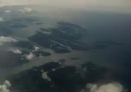
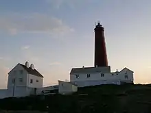
Solund is a municipality made up of many islands. The two largest islands are Sula and Ytre Sula. Other islands are Losna, Steinsundøyna, Nesøyna, Ospa, Rånøyna, Færøyna, Lågøyna, and Hågøyna. The westernmost point in Norway is Holmebåen in the tiny Utvær islands which are mostly uninhabited. Utvær Lighthouse is located at Utvær.
Solund is bordered to the north by the municipality of Askvoll, to the east by Fjaler and Hyllestad, to the south by Gulen, and to the west by the North Sea. The Sognesjøen strait runs along the southern border of the municipality. It is the main connection between the sea and the large Sognefjorden. The mouth of the Sognefjorden lies just east of Solund.
Economy
Fishing is the most important industry in Solund. Solund Verft is the largest industrial business with 21 employees working on the maintenance, reconstruction, and repair of ships. Solund is popular with boaters with its myriad exciting islands and also attracts numerous tourists looking for outdoor recreation and fishing. Utvær island and the Utvær Lighthouse is a popular destination for tourists during the summer.[29]
Attractions
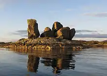
Gåsvær
Gåsvær is among the outermost islands of northern Solund. It is far west out at sea between the Lågøyfjorden and the Gåsværosen river outlet. The fishing banks are just off the island's coastline, and Gåsvær most probably has a long history of trade. In 1767, the island had both its own guesthouse and pub. Over the past century, the islanders have made their living from fishing and agriculture, and in more modern times, taking passengers over the waters and tourism. The oldest section of the characteristic main house dates back to the 18th century, while another section was built using timber from a shipwrecked sailing ship.[29]
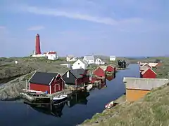
Utvær
One cannot travel any further west in Norway and still be on solid ground. There are no longer any permanent residents on the island of Utvær, but there are always two people on duty at the lighthouse. To visit Utvær one has to travel by boat. There is a service available on request from Kolgrov all year round. In the summer season there is a scheduled service with departures from Hardbakke, Eivindvik, and Korssund.
The County Governor of Vestland declared Utvær to be a nature reserve. This decision applies to the Utvær island group and surrounding sea. An exception is made for the island of Utvær itself and the sea immediately around it. The Norwegian Riksantikvar (preservation of Norwegian heritage) has made a proposal to preserve the lighthouse itself.
In the Middle Ages, Utvær Chapel was located to the south of the existing settlement. It is somewhat uncertain when the chapel was built. The first written references to if appear in the work of Bjørgynar Kalveskinn from 1320. The chapel had an income from gifts and fishing tithes. In the 17th century the chapel owned 15 cows and 27 sheep that were rented out. Later on in the 17th century the chapel of Utvær was robbed by Scottish pirates.[29]
The chapel was made of timber and was approximately 7.5 by 6.3 metres (25 ft × 21 ft), and it could seat a congregation of about 120. The chapel bell from 1641 is currently exhibited at the Heibergske Samlingar exhibition in Kaupanger. Four sermons a year were held in the chapel and the priest had to come by boat from Eivindvik. He was often stranded on the islands nearer the mainland as a result of bad weather. In 1718 the chapel was moved into the island of Husøy (Husøy Chapel). It was pulled down at the end of the 19th century when Straumen church was inaugurated.
The lighthouse burned down in February 1945 during an allied air attack during World War II. The lighthouse was reconstructed from 1948–1952. The lighthouse itself took on a different form from previously and the "balcony" on the top was one storey lower.[29]
Arboretum
The Coastal Arboretum in Hardbakke is a collection of trees and plants of largely indigenous species. There are 60 different species planted there. The rhododendron collection is a sight to behold in early summer. Integrated into the arboretum, there is a 5-kilometre (3.1 mi) long footpath over a variety of terrain with a wonderful view over the outer Sognefjord. There is also a marked footpath up to the top of Ravnenipa mountain.[29]
Notable people
- Mimi Sverdrup Lunden (1894 in Sulen – 1955) a Norwegian educator, non-fiction writer and proponent for women's rights
- Einar Sverdrup (1895 in Solund – 1942) a Norwegian mining engineer, killed in action during Operation Fritham
- Paul Vårdal (1925 in Solund – 2010) a Norwegian accountant and a pioneer of accountant education in Norway
References
- "Navn på steder og personer: Innbyggjarnamn" (in Norwegian). Språkrådet.
- "Forskrift om målvedtak i kommunar og fylkeskommunar" (in Norwegian). Lovdata.no.
- Statistisk sentralbyrå (2020). "Table: 06913: Population 1 January and population changes during the calendar year (M)" (in Norwegian).
- Statistisk sentralbyrå (2020). "09280: Area of land and fresh water (km²) (M)" (in Norwegian).
- Fjelltveit, Ingvild; Raunholm, Per Vidar (2016-12-20). "Foreslår å legge ned 17 lensmannskontor i Vest politidistrikt". NRK Hordaland (in Norwegian). Retrieved 2017-10-20.
- Jukvam, Dag (1999). "Historisk oversikt over endringer i kommune- og fylkesinndelingen" (PDF). Statistics Norway.
- Natvik, Oddvar (9 February 2005). "Some historical data on the 26 Kommunes". Archived from the original on 13 June 2008. Retrieved 13 June 2008.
- Rygh, Oluf (1919). Norske gaardnavne: Nordre Bergenhus amt (in Norwegian) (12 ed.). Kristiania, Norge: W. C. Fabritius & sønners bogtrikkeri. pp. 215–217.
- "Civic heraldry of Norway - Norske Kommunevåpen". Heraldry of the World. Retrieved 2017-10-22.
- Hansen, Tore, ed. (2016-05-12). "kommunestyre". Store norske leksikon (in Norwegian). Kunnskapsforlaget. Retrieved 2019-04-06.
- "Tall for Norge: Kommunestyrevalg 2019 - Vestland". Valg Direktoratet. Retrieved 2019-10-29.
- "Table: 04813: Members of the local councils, by party/electoral list at the Municipal Council election (M)" (in Norwegian). Statistics Norway.
- "Tall for Norge: Kommunestyrevalg 2011 - Sogn og Fjordane". Valg Direktoratet. Retrieved 2019-10-29.
- "Kommunestyrevalget 1995" (PDF) (in Norwegian). Oslo-Kongsvinger: Statistisk sentralbyrå. 1996. Retrieved 2020-02-18.
- "Kommunestyrevalget 1991" (PDF) (in Norwegian). Oslo-Kongsvinger: Statistisk sentralbyrå. 1993. Retrieved 2020-02-18.
- "Kommunestyrevalget 1987" (PDF) (in Norwegian). Oslo-Kongsvinger: Statistisk sentralbyrå. 1988. Retrieved 2020-02-18.
- "Kommunestyrevalget 1983" (PDF) (in Norwegian). Oslo-Kongsvinger: Statistisk sentralbyrå. 1984. Retrieved 2020-02-18.
- "Kommunestyrevalget 1979" (PDF) (in Norwegian). Oslo: Statistisk sentralbyrå. 1979. Retrieved 2020-02-18.
- "Kommunevalgene 1975" (PDF) (in Norwegian). Oslo: Statistisk sentralbyrå. 1977. Retrieved 2020-05-01.
- "Kommunevalgene 1972" (PDF) (in Norwegian). Oslo: Statistisk sentralbyrå. 1973. Retrieved 2020-05-01.
- "Kommunevalgene 1967" (PDF) (in Norwegian). Oslo: Statistisk sentralbyrå. 1967. Retrieved 2020-05-01.
- "Kommunevalgene 1963" (PDF) (in Norwegian). Oslo: Statistisk sentralbyrå. 1964. Retrieved 2020-05-01.
- "Kommunevalgene og Ordførervalgene 1959" (PDF) (in Norwegian). Oslo: Statistisk sentralbyrå. 1960. Retrieved 2020-05-01.
- "Kommunevalgene og Ordførervalgene 1955" (PDF) (in Norwegian). Oslo: Statistisk sentralbyrå. 1957. Retrieved 2020-05-01.
- "Kommunevalgene og Ordførervalgene 1951" (PDF) (in Norwegian). Oslo: Statistisk sentralbyrå. 1952. Retrieved 2020-05-01.
- "Kommunevalgene og Ordførervalgene 1947" (PDF) (in Norwegian). Oslo: Statistisk sentralbyrå. 1948. Retrieved 2020-05-01.
- "Kommunevalgene og Ordførervalgene 1945" (PDF) (in Norwegian). Oslo: Statistisk sentralbyrå. 1947. Retrieved 2020-05-01.
- "Kommunevalgene og Ordførervalgene 1937" (PDF) (in Norwegian). Oslo: Statistisk sentralbyrå. 1938. Retrieved 2020-05-01.
- GoNorway.no. "Solund in Norway". Retrieved 13 June 2008.
External links
| Wikimedia Commons has media related to Solund. |
- Municipal fact sheet from Statistics Norway (in Norwegian)
- Official website: Solund Kommune (in Norwegian)
- NRK: Fylkesleksikon - Solund Kommune (in Norwegian)
- Norway’s far-flung isle with a Viking spirit
 |
|  | |||