Sormano
Sormano (Valassinese Lombard: Surman [surˈmãː]) is a comune (municipality) in the Province of Como in the Italian region Lombardy, located about 45 kilometres (28 mi) north of Milan and about 15 kilometres (9 mi) northeast of Como. It is part of the mountain community of the Triangolo lariano, a local government with Canzo as its chief town and comprising the peninsula between the two branches of Lake Como.
Sormano
| |
|---|---|
| Comune di Sormano | |
 Coat of arms | |
Location of Sormano 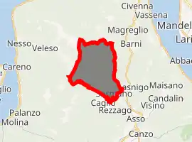
| |
 Sormano Location of Sormano in Italy 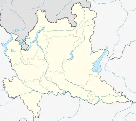 Sormano Sormano (Lombardy) | |
| Coordinates: 45°53′N 9°15′E | |
| Country | Italy |
| Region | Lombardy |
| Province | Como (CO) |
| Government | |
| • Mayor | Claudio D'Elia |
| Area | |
| • Total | 11.0 km2 (4.2 sq mi) |
| Elevation | 850 m (2,790 ft) |
| Population | |
| • Total | 703 |
| • Density | 64/km2 (170/sq mi) |
| Demonym(s) | Sormanesi |
| Time zone | UTC+1 (CET) |
| • Summer (DST) | UTC+2 (CEST) |
| Postal code | 22030 |
| Dialing code | 031 |
Sormano borders the following municipalities: Asso, Barni, Bellagio, Caglio, Lasnigo, Magreglio, Nesso, Zelbio.
The Muro di Sormano is one of the most severe hills to have been used in road cycling. It is associated with the Giro di Lombardia.
Twin towns
 San Cipriano Picentino, Italy, since 2007
References
- "Superficie di Comuni Province e Regioni italiane al 9 ottobre 2011". Istat. Retrieved 16 March 2019.
- All demographics and other statistics: Italian statistical institute Istat.
- "Popolazione Residente al 1° Gennaio 2018". Istat. Retrieved 16 March 2019.
This article is issued from Wikipedia. The text is licensed under Creative Commons - Attribution - Sharealike. Additional terms may apply for the media files.