South Carolina Highway 421
South Carolina Highway 421 (SC 421) is a 10.360-mile (16.673 km) state highway in the U.S. state of South Carolina. It is an alternate route to U.S. Route 1 (US 1) and US 78 between North Augusta and Aiken.
| ||||
|---|---|---|---|---|
| Augusta Road | ||||
 | ||||
| Route information | ||||
| Maintained by SCDOT | ||||
| Length | 10.360 mi[1] (16.673 km) | |||
| Existed | 1952–present | |||
| Major junctions | ||||
| South end | ||||
| North end | ||||
| Location | ||||
| Counties | Aiken | |||
| Highway system | ||||
| ||||

Route description
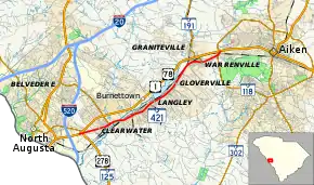
SC 421 begins where it splits off from US 1/US 78 (Jefferson Davis Highway) southwest of Clearwater; it immediately connects with US 278/SC 125 (Atomic Road). Heading northeast, it parallels US 1/US 78 to its south, going through the towns of Clearwater, Burnettown, Langley, Gloverville and Warrenville. Upon entering Aiken, it reconnects with US 1/US 78. A majority of the highway is four-lanes that travels a total of 10.4 miles (16.7 km).[2]
History
SC 421 was established by 1952 as a renumbering of US 1/US 78, which was realigned onto new four-lane routing just north of it. The route has remained unchanged since inception.[3][4]
Major intersections
The entire route is in Aiken County.
| Location | mi[1] | km | Destinations | Notes | |
|---|---|---|---|---|---|
| | 0.000 | 0.000 | Northbound lane only; southern terminus | ||
| Clearwater | 0.230 | 0.370 | Northern end of US 278 concurrency (northbound lane only); southbound lane exit onto interchange | ||
| 1.910 | 3.074 | Eastern terminus of SC 126 | |||
| Warrenville | 8.150 | 13.116 | Southern terminus of SC 191 | ||
| Aiken | 10.030 | 16.142 | |||
| 10.360 | 16.673 | Northern terminus | |||
| 1.000 mi = 1.609 km; 1.000 km = 0.621 mi | |||||
See also
 United States portal
 U.S. roads portal
References
- "Highway Logmile Report". South Carolina Department of Transportation. Retrieved November 11, 2020.
- South Carolina Highway 421 (Map). Cartography by Google. Google Maps. 2010.
- General Highway Map, Aiken County, South Carolina (PDF) (Map). Cartography by SCDOT. South Carolina Department of Transportation. 1940. Retrieved September 8, 2013.
- General Highway Map, Aiken County, South Carolina (PDF) (Map). Cartography by SCDOT. South Carolina Department of Transportation. 1956. Retrieved September 8, 2013.
External links
 Media related to South Carolina Highway 421 at Wikimedia Commons
- SC 421 at Virginia Highways' South Carolina Highways Annex