South Carolina Highway 118
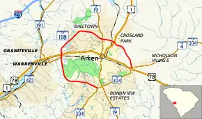
South Carolina Highway 118 (SC 118) is a 13.180-mile (21.211 km) state highway in the U.S. state of South Carolina. The highway is a beltway around downtown Aiken. The highway is officially designated on the road around the southwestern, western, and northern sides of the city. However, it is also concurrent with SC 302 on its southeastern quadrant.
| ||||
|---|---|---|---|---|
 | ||||
| Route information | ||||
| Maintained by SCDOT | ||||
| Length | 13.180 mi[1] (21.211 km) | |||
| Existed | 1975–present | |||
| Major junctions | ||||
| South end | ||||
| North end | ||||
| Location | ||||
| Counties | Aiken | |||
| Highway system | ||||
| ||||

Route description
According to the South Carolina Department of Transportation, SC 118 begins at an intersection with SC 302 (Silver Bluff Road) in southern Aiken, within Aiken County. It travels to the west-northwest, concurrent with SC 19 Truck. The two highways travel north of Houndslake Country Club and Aiken Elementary School before heading to the north-northwest. They cross over the Sand River. They also intersect SC 421 (Augusta Road). Just afterward, they travel underneath a railroad bridge and intersect U.S. Route 1 (US 1) and US 78 (Jefferson Davis Highway/Richland Avenue). At this intersection, US 1 Truck/US 78 Truck join the concurrency. They briefly travel outside of the city limits of Aiken. The four highways curve to the northeast and travel through University of South Carolina Aiken. At University Parkway, they re-enter Aiken. Just after Vaucluse Road, they curve to the east-southeast. Just before Arbor Court, they curve to the southeast. They curve to the east-southeast and intersect SC 19 (Laurens Street).[2]
At the intersection with SC 19, SC 19 Truck ends. The three highways pass Aiken High School. They cross some railroad tracks and have a second intersection with US 1 (York Street). Here, US 1 Truck ends. US 78 Truck/SC 118 travels to the southeast and leave the city limits of Aiken again. They curve to the south-southeast and intersect SC 4/SC 302 (Wagener Road). Here, SC 302 joins the concurrency. They curve to the south-southwest and have a second intersection with US 78 (Charleston Highway). Here, US 78 Truck ends. SC 118/SC 302 curve to the southeast, re-enter Aiken, and pass Citizens Park. They travel between Kennedy Middle School and Millbrook Elementary School and travel south of Virginia Acres Park. South of the park, they intersect SC 19 (Whiskey Road). Here, SC 19 Truck joins the concurrency. They curve to the west-southwest and meet Silver Bluff Road, where SC 302 turns left.[2]
Major intersections
The entire route is in Aiken County.
| Location | mi[1] | km | Destinations | Notes | |
|---|---|---|---|---|---|
| Aiken | 0.000 | 0.000 | Southern end of SC 302 concurrency; southern terminus | ||
| 4.630 | 7.451 | ||||
| 4.850 | 7.805 | Southern end of US 1 Truck/US 78 Truck concurrency; southern terminus of US 1 Truck; western terminus of US 78 Truck | |||
| 9.480 | 15.257 | Northern terminus of SC 19 Truck; northern end of SC 19 Truck concurrency | |||
| 10.480 | 16.866 | ||||
| | 13.180 | 21.211 | Northern end of US 1 Truck/US 78 Truck concurrency; western terminus of SC 4 Truck; northern terminus of SC 118 | ||
1.000 mi = 1.609 km; 1.000 km = 0.621 mi
| |||||
See also
 U.S. roads portal
 United States portal
References
- "Highway Logmile Report". South Carolina Department of Transportation. Retrieved December 24, 2020.
- Google (May 19, 2016). "South Carolina Highway 118" (Map). Google Maps. Google. Retrieved May 19, 2016.
External links
 Media related to South Carolina Highway 118 at Wikimedia Commons
- SC 118 at Virginia Highways' South Carolina Highways Annex