South Carolina Highway 642
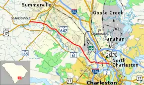
South Carolina Highway 642 (SC 642, also known as Dorchester Road), is a 19.292-mile (31.047 km) state highway in the southeastern part of the U.S. state of South Carolina. It travels within the Summerville and North Charleston areas.
| ||||
|---|---|---|---|---|
| Dorchester Road | ||||
 | ||||
| Route information | ||||
| Maintained by SCDOT | ||||
| Length | 19.292 mi[1][2] (31.047 km) | |||
| Existed | 1939–present | |||
| Major junctions | ||||
| West end | ||||
| ||||
| East end | ||||
| Location | ||||
| Counties | Dorchester, Charleston | |||
| Highway system | ||||
| ||||
Route description
SR 642 runs for 19.3 miles (31.1 km) from U.S. Route 17 Alternate (US 17 Alt.) southwest of Summerville to US 52/US 78 in North Charleston.[3] Dorchester Road is a heavily congested highway during morning and evening traffic periods.
History
Current plans call for widening of the road from Summerville to US 17 Alternate. This has been completed.[4]
Major intersections
| County | Location | mi[1][2] | km | Destinations | Notes |
|---|---|---|---|---|---|
| Dorchester | | 0.000 | 0.000 | Western end of US 17 Alt. Truck concurrency; western terminus of SC 642; southern terminus of US 17 Alt. Truck | |
| | 2.832 | 4.558 | Eastern end of US 17 Alt. Truck concurrency | ||
| Charleston | North Charleston | 16.542– 16.602 | 26.622– 26.718 | I-526 exit 15 | |
| 18.602 | 29.937 | I-26 exit 215 | |||
| 19.292 | 31.047 | Eastern terminus | |||
| 1.000 mi = 1.609 km; 1.000 km = 0.621 mi | |||||
See also
 United States portal
 U.S. roads portal
References
- "Highway Logmile Report". South Carolina Department of Transportation. Retrieved December 29, 2020.
- "Highway Logmile Report". South Carolina Department of Transportation. Retrieved December 29, 2020.
- Google (August 29, 2014). "South Carolina Highway 642" (Map). Google Maps. Google. Retrieved August 29, 2014.
- "Project #3 Dorchester Road Improvements" (Press release). Dorchester County Penny Sales Tax Transportation Authority. Retrieved August 3, 2013.
External links
 Media related to South Carolina Highway 642 at Wikimedia Commons
- SC 642 at Virginia Highways' South Carolina Highways Annex
This article is issued from Wikipedia. The text is licensed under Creative Commons - Attribution - Sharealike. Additional terms may apply for the media files.
