Dorchester County, South Carolina
Dorchester County is a county located in the U.S. state of South Carolina. As of the 2010 census, the population was 136,555.[1] Its county seat is St. George.[2]
Dorchester County | |
|---|---|
 | |
 Seal | |
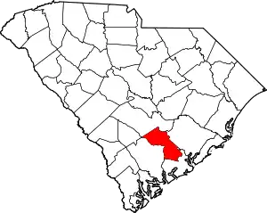 Location within the U.S. state of South Carolina | |
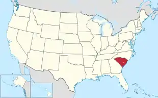 South Carolina's location within the U.S. | |
| Coordinates: 33°05′N 80°24′W | |
| Country | |
| State | |
| Founded | 1897 |
| Named for | Dorchester, Massachusetts |
| Seat | St. George |
| Largest City | North Charleston (partial) |
| Area | |
| • Total | 576 sq mi (1,490 km2) |
| • Land | 573 sq mi (1,480 km2) |
| • Water | 2.6 sq mi (7 km2) 0.4%% |
| Population (2010) | |
| • Total | 136,555 |
| • Estimate (2019) | 162,809 |
| • Density | 240/sq mi (92/km2) |
| Time zone | UTC−5 (Eastern) |
| • Summer (DST) | UTC−4 (EDT) |
| Congressional districts | 1st, 6th |
| Website | www |
Dorchester County is included in the Charleston-North Charleston, SC Metropolitan Statistical Area.
History
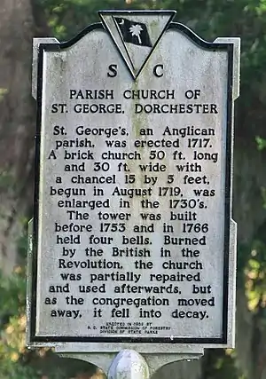
Dorchester County is named for its first settlement area, which was established by Congregationalists in 1696. These settlers applied the name "Dorchester" after their last residence in Dorchester, Massachusetts.[3]
Dorchester was not established as a separate county until 1897. However, when it was separately established, it came from parts of the neighboring Colleton and Berkeley counties.[4]
Geography
According to the U.S. Census Bureau, the county has a total area of 576 square miles (1,490 km2), of which 573 square miles (1,480 km2) is land and 2.6 square miles (6.7 km2) (0.4%) is water.[5]
Adjacent counties
- Bamberg County - west
- Berkeley County - east
- Charleston County - southeast
- Colleton County - southwest
- Orangeburg County - northwest
Demographics
| Historical population | |||
|---|---|---|---|
| Census | Pop. | %± | |
| 1900 | 16,294 | — | |
| 1910 | 17,891 | 9.8% | |
| 1920 | 19,459 | 8.8% | |
| 1930 | 18,956 | −2.6% | |
| 1940 | 19,928 | 5.1% | |
| 1950 | 22,601 | 13.4% | |
| 1960 | 24,383 | 7.9% | |
| 1970 | 32,276 | 32.4% | |
| 1980 | 58,761 | 82.1% | |
| 1990 | 83,060 | 41.4% | |
| 2000 | 96,413 | 16.1% | |
| 2010 | 136,555 | 41.6% | |
| 2019 (est.) | 162,809 | [6] | 19.2% |
| U.S. Decennial Census[7] 1790-1960[8] 1900-1990[9] 1990-2000[10] 2010-2019[1] | |||
2000 census
At the 2000 census there were 96,413 people, 34,709 households, and 26,309 families living in the county. The population density was 168 people per square mile (65/km2). There were 37,237 housing units at an average density of 65 per square mile (25/km2). The racial makeup of the county was 71.05% White, 25.08% Black or African American, 0.73% Native American, 1.13% Asian, 0.07% Pacific Islander, 0.59% from other races, and 1.36% from two or more races. 1.79% of the population were Hispanic or Latino of any race.[11] Of the 34,709 households 40.00% had children under the age of 18 living with them, 57.20% were married couples living together, 14.60% had a female householder with no husband present, and 24.20% were non-families. 20.20% of households were one person and 6.50% were one person aged 65 or older. The average household size was 2.72 and the average family size was 3.13.
The age distribution was 28.90% under the age of 18, 7.70% from 18 to 24, 31.60% from 25 to 44, 22.60% from 45 to 64, and 9.10% 65 or older. The median age was 35 years. For every 100 females, there were 95.80 males. For every 100 females age 18 and over, there were 91.70 males.
The median household income was $43,316 and the median family income was $50,177. Males had a median income of $35,423 versus $24,405 for females. The per capita income for the county was $18,840. About 7.10% of families and 9.70% of the population were below the poverty line, including 11.40% of those under age 18 and 13.30% of those age 65 or over.
2010 census
At the 2010 census, there were 136,555 people, 50,259 households, and 36,850 families living in the county.[12] The population density was 238.2 inhabitants per square mile (92.0/km2). There were 55,186 housing units at an average density of 96.3 per square mile (37.2/km2).[13] The racial makeup of the county was 67.8% white, 25.8% black or African American, 1.5% Asian, 0.7% American Indian, 0.1% Pacific islander, 1.4% from other races, and 2.6% from two or more races. Those of Hispanic or Latino origin made up 4.4% of the population.[12] In terms of ancestry,[14]
Of the 50,259 households, 40.3% had children under the age of 18 living with them, 52.6% were married couples living together, 16.0% had a female householder with no husband present, 26.7% were non-families, and 21.6% of households were made up of individuals. The average household size was 2.68 and the average family size was 3.11. The median age was 35.6 years.[12]
The median household income was $55,034 and the median family income was $63,847. Males had a median income of $45,659 versus $32,221 for females. The per capita income for the county was $24,497. About 9.0% of families and 11.2% of the population were below the poverty line, including 16.4% of those under age 18 and 9.1% of those age 65 or over.[15]
Government and infrastructure
The South Carolina Department of Corrections operates the Lieber Correctional Institution in Ridgeville in Dorchester County.[16] The prison houses the state's male death row.[17]
Politics
| Year | Republican | Democratic | Third parties |
|---|---|---|---|
| 2020 | 54.2% 41,913 | 43.8% 33,824 | 2.0% 1,541 |
| 2016 | 55.9% 34,987 | 38.5% 24,055 | 5.6% 3,525 |
| 2012 | 57.2% 32,531 | 41.2% 23,445 | 1.6% 879 |
| 2008 | 57.1% 29,929 | 41.6% 21,806 | 1.3% 670 |
| 2004 | 62.9% 26,006 | 35.7% 14,733 | 1.4% 578 |
| 2000 | 61.6% 20,734 | 36.2% 12,168 | 2.2% 739 |
| 1996 | 56.6% 15,283 | 36.8% 9,931 | 6.6% 1,773 |
| 1992 | 53.5% 15,004 | 32.7% 9,160 | 13.8% 3,865 |
| 1988 | 66.4% 14,756 | 33.2% 7,371 | 0.5% 105 |
| 1984 | 68.3% 15,289 | 31.4% 7,037 | 0.3% 73 |
| 1980 | 59.5% 10,893 | 39.6% 7,237 | 0.9% 168 |
| 1976 | 45.3% 6,695 | 54.4% 8,046 | 0.3% 38 |
| 1972 | 68.1% 8,095 | 30.3% 3,606 | 1.6% 185 |
| 1968 | 31.2% 3,354 | 35.9% 3,855 | 32.9% 3,539 |
| 1964 | 76.1% 5,109 | 23.9% 1,604 | |
| 1960 | 59.9% 3,525 | 40.1% 2,357 | |
| 1956 | 15.7% 504 | 26.8% 862 | 57.5% 1,851 |
| 1952 | 73.1% 2,319 | 26.9% 852 | |
| 1948 | 2.9% 85 | 4.9% 143 | 92.3% 2,722 |
| 1944 | 3.9% 65 | 70.5% 1,181 | 25.7% 430 |
| 1940 | 10.0% 110 | 90.0% 993 | |
| 1936 | 3.1% 28 | 97.0% 889 | |
| 1932 | 1.6% 23 | 98.2% 1,412 | 0.2% 3 |
| 1928 | 3.8% 44 | 96.2% 1,105 | |
| 1924 | 2.8% 20 | 97.2% 697 | |
| 1920 | 6.4% 60 | 93.6% 874 | |
| 1916 | 5.8% 44 | 94.0% 716 | 0.3% 2 |
| 1912 | 3.0% 18 | 94.9% 576 | 2.1% 13 |
| 1908 | 10.4% 103 | 89.1% 883 | 0.5% 5 |
| 1904 | 8.9% 69 | 91.1% 706 | |
| 1900 | 5.3% 43 | 94.7% 770 |
Communities
City
- North Charleston (partly in Berkeley County and Charleston County)
Town
- Harleyville
- Lincolnville (mostly in Charleston County)
- Reevesville
- Ridgeville
- St. George (county seat)
- Summerville (partly in Berkeley and Charleston Counties)
Census-designated place
- Ladson (partly in Berkeley County and Charleston County)
Unincorporated communities
- Grover
- Byrds
- Dorchester
- Jedburg
- Knightsville
See also
References
- "State & County QuickFacts". United States Census Bureau. Archived from the original on June 6, 2011. Retrieved November 23, 2013.
- "Find a County". National Association of Counties. Archived from the original on 2011-05-31. Retrieved 2011-06-07.
- Gannett, Henry (1905). The Origin of Certain Place Names in the United States. Govt. Print. Off. pp. 108.
- Dorchester County Online Archived February 19, 2009, at the Wayback Machine
- "2010 Census Gazetteer Files". United States Census Bureau. August 22, 2012. Retrieved March 17, 2015.
- "Population and Housing Unit Estimates". Retrieved May 21, 2020.
- "U.S. Decennial Census". United States Census Bureau. Retrieved March 17, 2015.
- "Historical Census Browser". University of Virginia Library. Retrieved March 17, 2015.
- Forstall, Richard L., ed. (March 27, 1995). "Population of Counties by Decennial Census: 1900 to 1990". United States Census Bureau. Retrieved March 17, 2015.
- "Census 2000 PHC-T-4. Ranking Tables for Counties: 1990 and 2000" (PDF). United States Census Bureau. April 2, 2001. Retrieved March 17, 2015.
- "U.S. Census website". United States Census Bureau. Retrieved 2011-05-14.
- "DP-1 Profile of General Population and Housing Characteristics: 2010 Demographic Profile Data". United States Census Bureau. Archived from the original on 2020-02-13. Retrieved 2016-03-09.
- "Population, Housing Units, Area, and Density: 2010 - County". United States Census Bureau. Archived from the original on 2020-02-13. Retrieved 2016-03-09.
- "DP02 SELECTED SOCIAL CHARACTERISTICS IN THE UNITED STATES – 2006-2010 American Community Survey 5-Year Estimates". United States Census Bureau. Archived from the original on 2020-02-13. Retrieved 2016-03-09.
- "DP03 SELECTED ECONOMIC CHARACTERISTICS – 2006-2010 American Community Survey 5-Year Estimates". United States Census Bureau. Archived from the original on 2020-02-13. Retrieved 2016-03-09.
- "Lieber Correctional Institution." South Carolina Department of Corrections. Retrieved on August 17, 2010.
- "Death Row/Capital Punishment." South Carolina Department of Corrections. Retrieved on August 17, 2010.
- Leip, David. "Dave Leip's Atlas of U.S. Presidential Elections". uselectionatlas.org. Retrieved 2018-03-13.
External links
- Dorchester County website
- US Census Bureau Data
 Geographic data related to Dorchester County, South Carolina at OpenStreetMap
- Dorchester County History and Images
Places adjacent to Dorchester County, South Carolina | ||||||||||
|---|---|---|---|---|---|---|---|---|---|---|
| ||||||||||
Municipalities and communities of Dorchester County, South Carolina, United States | ||
|---|---|---|
| City | Map of South Carolina highlighting Dorchester County | |
| Towns | ||
| Unincorporated community | ||
| Ghost town | ||
| Footnotes | ‡This populated place also has portions in an adjacent county or counties | |
| ||
| Authority control |
|---|