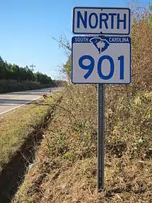
South Carolina Highway 901
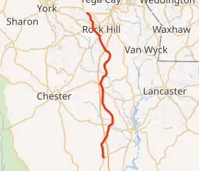
South Carolina Highway 901 (SC 901) is a 38.730-mile (62.330 km) primary state highway in the U.S. state of South Carolina. It serves as a slower alternate rural route to Interstate 77 (I-77) and the western bypass of Rock Hill.
| ||||
|---|---|---|---|---|
| ||||
| Route information | ||||
| Maintained by SCDOT | ||||
| Length | 38.730 mi[1][2][3] (62.330 km) | |||
| Existed | 1931–present | |||
| Major junctions | ||||
| South end | ||||
| North end | ||||
| Location | ||||
| Counties | Fairfield, Chester, York | |||
| Highway system | ||||
| ||||

Route description
SC 901 begins along SC 200 near I-77. Going north, it hovers to the west and then east of I-77 and then passes through Richburg. After entering York County, it has its own interchange with I-77, then proceeds to form the western bypass of Rock Hill. It is a two-lane rural highway in Fairfield and Chester counties, four lanes wide in York County.[4]
In Rock Hill, SC 901 is known as Heckle Boulevard in honor of H.N. Heckle, who served as South Carolina Department of Transportation District 4 Construction Engineer during the late 1940s through 1960s.
History
Established as a new primary routing in 1930 or 1931, it originally ran from SC 9 near Richburg to the York County line. In 1933, it was extended north to U.S. Route 21 (US 21). In 1940, it was extended south to its current southern terminus with SC 22 (today's SC 200). Between 1949-50, it was briefly truncated south at SC 97. Between 1974-79, it was extended north to SC 5. In 1992, it was extended again to its current northern terminus with SC 161/SC 274.[5]
In 2010, SC 901 was widened to four lanes from I-77 to SC 121 funded through the "Pennies for Progress" project fund.
Major intersections
| County | Location | mi[1][2][3] | km | Destinations | Notes |
|---|---|---|---|---|---|
| Fairfield | | 0.000 | 0.000 | Southern terminus | |
| Chester | | 7.970 | 12.826 | ||
| Richburg | 17.510 | 28.180 | Southern end of SC 9 concurrency | ||
| 18.700 | 30.095 | Western terminus of SC 223 | |||
| | 19.070 | 30.690 | Northern end of SC 9 concurrency | ||
| York | Rock Hill | 28.560– 28.570 | 45.963– 45.979 | I-77 exit 73 | |
| 31.740 | 51.081 | Southern end of SC 72 concurrency | |||
| 32.040 | 51.563 | Northern end of SC 72 concurrency; southern end of SC 5 concurrency | |||
| 34.690 | 55.828 | ||||
| 35.280 | 56.778 | Northern end of SC 5 concurrency; northern terminus of SC 5 Conn. | |||
| 38.730 | 62.330 | Northern terminus | |||
1.000 mi = 1.609 km; 1.000 km = 0.621 mi
| |||||
See also
 U.S. roads portal
References
- "Highway Logmile Report". South Carolina Department of Transportation. Retrieved November 28, 2020.
- "Highway Logmile Report". South Carolina Department of Transportation. Retrieved November 28, 2020.
- "Highway Logmile Report". South Carolina Department of Transportation. Retrieved November 28, 2020.
- Google (November 23, 2012). "South Carolina Highway 901" (Map). Google Maps. Google. Retrieved November 23, 2012.
- "Mapmikey's South Carolina Highways Page (SC 900-909)". Retrieved November 23, 2012.
External links
 Media related to South Carolina Highway 901 at Wikimedia Commons
- SC 901 South Carolina Highway Annex
- Former SC 901 Alt. South Carolina Highway Annex
