South Carolina Highway 121
South Carolina Highway 121 (SC 121) is a 134.200-mile (215.974 km) major state highway that travels north and south in central parts of the U.S. state of South Carolina. The highway is actually part of a long multi-state highway that also exists in Florida and Georgia, as Florida State Road 121 and Georgia State Route 121, respectively. Some see it as a de facto auxiliary route from U.S. Route 21 (US 21) in Rock Hill. Efforts to have the road upgraded to such status have failed however.
| ||||
|---|---|---|---|---|
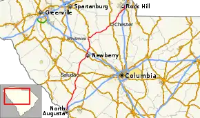 Route of SC 121 highlighted in red | ||||
| Route information | ||||
| Maintained by SCDOT | ||||
| Length | 134.200 mi[1][2][3][4][5][6][7] (215.974 km) | |||
| Existed | 1964–present | |||
| Major junctions | ||||
| South end | ||||
| North end | ||||
| Location | ||||
| Counties | Aiken, Edgefield, Saluda, Newberry, Union, Chester, York | |||
| Highway system | ||||
| ||||

Route description
SC 121 continues its concurrency with U.S. Route 25 (US 25) from Augusta, Georgia into North Augusta, South Carolina. In the Schultz Hill section of North Augusta, US 25/SC 121 leaves the concurrency with US 1 and US 78, and heads north. Still within North Augusta, it has an interchange with Interstate 520 (I-520) at exit 22 and I-20 (at exit 5).[8]
In Trenton at the northern terminus of SC 19, US 25 turns to the north and SC 121 becomes an independent route for the first time. From there it runs mainly through rural western South Carolina. Johnston is where the route serves as the northern terminus of SC 191 and later crosses SC 23.[8]
In Saluda, SC 121 is overlapped by US 178/SC 39, then intersects US 378. The overlap with US 178/SC 39 ends at Travis Road. Later it crosses a bridge over the Saluda River and is then overlapped with SC 34 until it reaches Newberry. Barely inside Newberry, the route becomes the terminus of SC 395 and then has a major intersection with US 76. Further north it encounters a quarter-cloverleaf interchanges with I-26 (at exit 72).[8]
North of Newberry, it encounters yet another concurrency with US 176, which it follows straight north before curving to the west as it enters Whitmire, where the routes make a sharp turn to the east and encounters the beginning of a long concurrency with SC 72. After a bridge over the Enoree River, the concurrency with US 176 ends just east of Whitmire.[8]
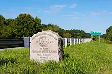
SC 121/72 runs through Carlisle where it has another concurrency with SC 215, which ends east of the bridge over the Broad River, which contains a monument to an American Revolutionary battle known as the Battle of Fishdam Ford.[8]
In Chester SC 121/72 has another concurrency, this time with US 321/SC 9. This concurrency runs southeast until US 321 branches off to the south at the southern terminus of US 321 Business (US 321 Bus.). The routes continue to the east along SC 97, running beneath a railroad bridge, and then turning toward the north. SC 9 makes a right turn at Lancaster Avenue, which is the eastern terminus of SC 9 Bus. SC 121/72/97 has an at-grade crossing with another railroad line leading to the city, and then SC 121/72 branches off to the right at Saluda Road (SC 72 Bus.), while SC 97 continues north.[8]
The concurrency with SC 72 finally ends at SC 901 in Rock Hill. Within the city, it joins briefly with SC 5, before merging with its final concurrency, US 21. Traversing east of the downtown area, its journey ends at Cherry Road, where US 21 continues north towards Fort Mill, while also connecting with SC 322.[8]
History
SC 121 had two previous stints in the state before its current routing was established. The first SC 121 was established in 1925 or 1926 as a new primary routing; it traversed from SC 27 in Aiken, northeast through Wagener and Pelion, to SC 2/SC 12 in Springdale. In 1928, it was renumbered as SC 215.
The second SC 121 was established in 1929 or 1930 as new primary routing; it traversed from US 21 in Branchville, east through Bowman, to SC 31 in Providence. In 1937 or 1938, SC 121 was extended along US 78 before branching off to end at SC 65; its eastern terminus was also extended to US 15. In 1940, SC 121 was extended southwest to SC 362, and east to SC 6 in Vance. In 1948, SC 121 was truncated on both ends, from US 21 to US 15; its routing to SC 61 became Farrell's Road (S-5-18). By 1952, it was extended east to SC 310 in Vance. In 1953, it was extended completely back to SC 6. In 1962-1964, the entire route was renumbered as SC 210.[9][10]
The third, and current, SC 121 was established in 1962-1964, which formed a three-state route (continues south as Georgia State Route 121 and Florida State Road 121 to Lebanon Station, Florida). From North Augusta to Rock Hill, it was placed on concurrencies with various highways throughout the state; with exception around Whitmire, where it replaced part of SC 19. Its routing has remained unchanged since inception.[11][12][13][14]
Major intersections
| County | Location | mi[1][2][3][4][5][6][7] | km | Destinations | Notes |
|---|---|---|---|---|---|
| Aiken | North Augusta | 0.000 | 0.000 | Southern end of US 1/US 78/US 278 and US 25 concurrencies; continuation from Georgia over the Savannah River | |
| 0.188– 0.340 | 0.303– 0.547 | 5th Street Bridge / River North Drive | Interchange | ||
| 0.710– 0.714 | 1.143– 1.149 | Northern end of US 1 and US 78/US 278 concurrencies | |||
| 0.860 | 1.384 | East Buena Vista Avenue east (SC 125 Conn. south)[15] | Southern end of SC 125 Conn. concurrency | ||
| 0.970 | 1.561 | East Buena Vista Avenue west (SC 125 Conn. north)[15] | Northern end of SC 125 Conn. concurrency | ||
| 1.390 | 2.237 | Southern end of SC 125 Truck/SC 230 concurrencies; southern terminus of SC 125 Truck and SC 230 | |||
| 1.820 | 2.929 | Northern end of SC 125 Truck/SC 230 concurrency | |||
| 3.590 | 5.778 | Northern terminus of US 25 Bus. | |||
| 4.610 | 7.419 | Western terminus of SC 126 | |||
| 6.170 | 9.930 | Northern terminus of US 25 Connector; I-520 exit 22 | |||
| 7.020 | 11.298 | I-20 exit 5 | |||
| Edgefield | Trenton | 20.360– 20.410 | 32.766– 32.847 | Northern end of US 25 concurrency; northern terminus of SC 19 | |
| 20.940 | 33.700 | Northern terminus of SC 19 Conn.; western terminus of West Wake Street | |||
| | 27.140 | 43.678 | Northern terminus of SC 191 | ||
| Johnston | 28.380 | 45.673 | |||
| Saluda | | 36.440 | 58.644 | Northern terminus of SC 193 | |
| Saluda | 40.980 | 65.951 | Southern end of US 178/SC 39 concurrency | ||
| 41.180 | 66.273 | ||||
| 41.530 | 66.836 | Northern end of US 178/SC 39 concurrency; western terminus of US 178 Conn. | |||
| Newberry | Silverstreet | 56.700 | 91.250 | Southern end of SC 34 concurrency; to Ninety Six National Historic Site | |
| | 61.230 | 98.540 | Northern end of SC 34 concurrency | ||
| | 61.950 | 99.699 | Dixie Drive east (SC 34 Conn. east) – Winnsboro | Western terminus of SC 34 Conn. | |
| Newberry | 64.090 | 103.143 | Northern terminus of SC 395 | ||
| | 65.680 | 105.702 | |||
| | 67.480– 67.519 | 108.599– 108.661 | I-26 exit 72 | ||
| | 73.500 | 118.287 | Southern end of US 176 concurrency | ||
| Whitmire | 81.850 | 131.725 | Southern end of SC 72 concurrency | ||
| Enoree River | 82.337 | 132.509 | Senator Marvin E. Abrams Bridge | ||
| Union | | 82.360 | 132.546 | Eastern end of US 176 concurrency | |
| | 82.570 | 132.884 | Eastern terminus of SC 72 Conn. | ||
| Carlisle | 91.550 | 147.335 | Western end of SC 215 concurrency | ||
| Chester | | 95.480 | 153.660 | Eastern end of SC 215 concurrency | |
| Chester | 107.970 | 173.761 | Western end of US 321 and SC 9 concurrencies; southern terminus of West End Street | ||
| 109.810 | 176.722 | Eastern end of US 321 concurrency; western end of SC 97 concurrency; southern terminus of US 321 Bus. | |||
| 111.030 | 178.685 | Eastern end of SC 9 concurrency; southern terminus of SC 9 Bus. | |||
| 112.050 | 180.327 | Eastern end of SC 97 concurrency | |||
| Lewis | 117.270 | 188.728 | Western end of SC 909 concurrency | ||
| 117.370 | 188.889 | Eastern end of SC 909 concurrency | |||
| York | | 123.940 | 199.462 | Eastern terminus of SC 324 | |
| Rock Hill | 128.020 | 206.028 | Northern end of SC 72 concurrency | ||
| 128.230 | 206.366 | Southern end of SC 5 concurrency | |||
| 130.420 | 209.891 | Northern end of SC 5 concurrency | |||
| 130.800 | 210.502 | Southern end of US 21 concurrency | |||
| 131.070 | 210.937 | To Catawba Reservation | |||
| 134.200 | 215.974 | Northern end of US 21 concurrency; northern terminus; eastern terminus of SC 322 | |||
1.000 mi = 1.609 km; 1.000 km = 0.621 mi
| |||||
Special routes
Chester business loop
| |
|---|---|
| Location | Chester, South Carolina |
| Length | 2.6 mi[16] (4.2 km) |
| Existed | 1964–c. 1987 |
SC 121 Business (SC 121 Bus.) was established in 1964 to run concurrently with SC 72 Bus.; through downtown Chester, via West End Street, Main Street and Saluda Street/Road. It was never part of mainline SC 121, as it bypassed Chester to the south and east with SC 72. It is unknown when the business loop was decommissioned.
See also
 United States portal
 U.S. roads portal
References
- "Highway Logmile Report". South Carolina Department of Transportation. Retrieved December 4, 2020.
- "Highway Logmile Report". South Carolina Department of Transportation. Retrieved December 4, 2020.
- "Highway Logmile Report". South Carolina Department of Transportation. Retrieved December 4, 2020.
- "Highway Logmile Report". South Carolina Department of Transportation. Retrieved December 4, 2020.
- "Highway Logmile Report". South Carolina Department of Transportation. Retrieved December 4, 2020.
- "Highway Logmile Report". South Carolina Department of Transportation. Retrieved December 4, 2020.
- "Highway Logmile Report". South Carolina Department of Transportation. Retrieved December 4, 2020.
- Google (April 7, 2014). "South Carolina Highway 121" (Map). Google Maps. Google. Retrieved April 7, 2014.
- General Highway Map, Orangeburg County, South Carolina (PDF) (Map). Cartography by SCDOT. South Carolina Department of Transportation. 1940. Retrieved April 7, 2014.
- General Highway Map, Orangeburg County, South Carolina (PDF) (Map). Cartography by SCDOT. South Carolina Department of Transportation. 1966. Retrieved April 7, 2014.
- General Highway Map, Aiken County, South Carolina (PDF) (Map). Cartography by SCDOT. South Carolina Department of Transportation. 1963. Retrieved April 7, 2014.
- General Highway Map, Aiken County, South Carolina (PDF) (Map). Cartography by SCDOT. South Carolina Department of Transportation. 1967. Retrieved April 7, 2014.
- General Highway Map, Newberry County, South Carolina (PDF) (Map). Cartography by SCDOT. South Carolina Department of Transportation. 1963. Retrieved April 7, 2014.
- General Highway Map, Newberry County, South Carolina (PDF) (Map). Cartography by SCDOT. South Carolina Department of Transportation. 1968. Retrieved April 7, 2014.
- Aiken & North Augusta Urban Area (PDF) (Map). South Carolina Department of Transportation. August 2019. p. Sheet 6. Retrieved September 12, 2020.
- Google (September 1, 2013). "Overview map of SC 121 Bus. (Chester)" (Map). Google Maps. Google. Retrieved September 1, 2013.
External links
 Media related to South Carolina Highway 121 at Wikimedia Commons
- Mapmikey's South Carolina Highways Page: SC 121
- Mapmikey's South Carolina Highways Page: Former SC 121 Business
