South Coogee, New South Wales
South Coogee is a coastal suburb in south-eastern Sydney, in the state of New South Wales, Australia. South Coogee is located 9 kilometres south-east of the Sydney central business district, in the local government area of the City of Randwick and part of the Eastern Suburbs region.
| South Coogee Sydney, New South Wales | |||||||||||||||
|---|---|---|---|---|---|---|---|---|---|---|---|---|---|---|---|
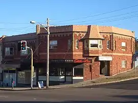 Shopping strip, Malabar Road | |||||||||||||||
| Population | 5,502 (2016 census)[1] | ||||||||||||||
| Postcode(s) | 2034 | ||||||||||||||
| Location | 9 km (6 mi) south-east of Sydney CBD | ||||||||||||||
| LGA(s) | City of Randwick | ||||||||||||||
| State electorate(s) | Coogee | ||||||||||||||
| Federal Division(s) | Kingsford Smith | ||||||||||||||
| |||||||||||||||
Coogee is a separate suburb to the north. South Coogee is surrounded by the suburbs of Coogee, Kingsford and Maroubra.
History
Coogee is said to be taken from a local Aboriginal word koojah which means "smelly place", or "stinking seaweed", a reference to the smell of decaying kelp washed up on the beach. Although at certain times large quantities of seaweed are still washed up, it is usually removed before it gets a chance to stink.[2]
Early visitors to the area, from the 1820s onwards, were never able to confirm exactly what "Coogee" meant, or if it in fact related to Coogee Beach. Another name, "Bobroi", was also recalled as the indigenous name for the locality. Some evidence suggests that the word "Coogee" may in fact be the original Aboriginal place name for the next bay to the north, now known as Gordon's Bay.[3]
Coogee was gazetted as a village in 1838, growing slowly until it was connected to the city by electric tram in 1902.
Randwick cemetery
Until the 1870s, the Randwick Municipality had only one cemetery, which was at St Jude's Church, Avoca Street. In addition, Rookwood Cemetery was also used, but this was too far away. The residents petitioned to have another local cemetery, and in 1872, permission was granted for Randwick Council to acquire land for a second cemetery. Land was bought in what is now the South Coogee area, and the new cemetery was ready for use in July 1874. Simeon Henry Pearce, an early Mayor, was appointed manager of the cemetery. Well-known burials include:
- Ernest Broughton, mayor of Ashfield and Member of the New South Wales Legislative Assembly
- the Hannan family, publishers of the Randwick Coogee Weekly
- Darby Munro, a well-known jockey
- Sir John See, Mayor of Randwick 1880-81 and 1886, and 14th Premier of N.S.W. (1901-1904)
- Charles Henry Streeton, the father of painter Sir Arthur Ernest Streeton
- the Veness family of business people, including Fred Veness, Randwick Postmaster 1864-78[4]
Population
According to the 2016 census of Population, there were 5,502 people in South Coogee.
- Aboriginal and Torres Strait Islander people made up 2.2% of the population.
- 61.3% of people were born in Australia. The next most common countries of birth were England 5.1%, South Africa 2.0% and China 1.9%.
- 70.0% of people spoke only English at home. Other languages spoken at home included Greek 4.1%, Russian 3.0% and Mandarin 2.2%.
- The most common responses for religion were Catholic 29.2% and No Religion 25.8%.[1]
Sport and recreation
Coogee is represented in one of the most popular sporting competitions in Australia, the National Rugby League, by the local Rugby league club, the South Sydney Rabbitohs. The Rabbitohs have represented the area in the league since 1908.
Transport
There are buses running along Malabar Rd and that is the only transport in the area.
Routes 353 - Northbound to Bondi Junction via Coogee, Southbound to Eastgardens via Maroubra Jn
Routes 376 & 377 - Northbound to City via Randwick Jn, Southbound to Maroubra Beach.
Landmarks
Latham Park is a large recreation area that features football fields, cricket pitches, tennis courts and bowls greens. It sits beside Endeavour House, a Department of Defence facility for the Royal Australian Navy. A small shopping strip is located in Malabar Road, close to the boundary of Randwick Cemetery. Another strip of shops sits one kilometre further south along Malabar Road at the corner of Torrington Road,
Lurline Bay is a secluded rocky basin located between Coogee and Maroubra Beaches in suburb of South Coogee.Nestled between weather sculptured headlands, the small bay can only be accessed via the coastal walk from either Seaside Parade to the north or Marine Parade if coming from Maroubra Beach.
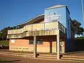 Jeffrey Sayle Pavilion, Latham Park
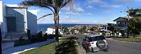
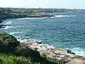 View from Coastal Walk, looking towards Coogee Beach
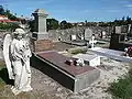 Randwick Cemetery, Malabar Road
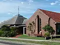 St Paul's Anglican Church, Gregory Street
References
- Australian Bureau of Statistics (27 June 2017). "South Coogee (State Suburb)". 2016 Census QuickStats. Retrieved 19 March 2018.

- The Book of Sydney Suburbs, Frances Pollon, Angus & Robertson Publishers, 1990, ISBN 0-207-14495-8, p.70
- ^Aboriginal Place Names Map Archived 27 January 2006 at the Wayback Machine
- Randwick Council Website:Retrieved 13 March 2009 Archived 13 June 2009 at the Wayback Machine
| Wikimedia Commons has media related to South Coogee, New South Wales. |