Eastern Suburbs (Sydney)
The Eastern Suburbs is the metropolitan region directly to the east and south-east of the central business district in Sydney, New South Wales, Australia.
| Eastern Suburbs New South Wales | |
|---|---|
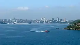 The Eastern Suburbs from Port Jackson | |
| Population | 267,037 (2016 census)[1] |
| LGA(s) | |
| State electorate(s) | |
| Federal Division(s) | |
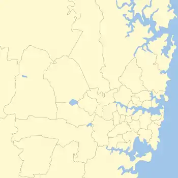
Location
"Eastern Suburbs" is a customary concept, not legal or administrative, and as such its boundaries are ill-defined, and vary in different contexts.
Customarily, it is often used in both a narrow sense and a broad sense. In the narrow sense, the Eastern Suburbs refer only to the suburbs to the east of the Sydney city centre and around the southern shore of Sydney Harbour to the Pacific Ocean, and roughly corresponds to the Parish of Alexandria, a cadastral unit used for land title purposes. In the broad sense, the "Eastern Suburbs" also includes the "South-eastern Suburbs" located further to the south, between Botany Bay and the Pacific Ocean and east of Sydney Airport. The South-eastern Suburbs roughly correspond to the cadastral Parish of Botany. In this wider sense, the Eastern Suburbs include the suburbs within the local government areas of the Municipality of Woollahra, Waverley Council, City of Randwick, and parts of Bayside Council and the City of Sydney. In the wider sense, the Eastern Suburbs include the entire eastern seaboard of Sydney between Sydney Harbour and Port Botany, extending from the peninsula of South Head at Watsons Bay in the nouth to the suburb of La Perouse in the south.[2]
The Australian Bureau of Statistics defines a "Eastern Suburbs Statistical Subdivision" which is a subset of the customary usage. This subdivision includes only the Woollahra, Waverley and Randwick local government areas. As at the 2016 census, the region had an estimated population of 267,037,[1] following an estimated resident population of 249,546 as at the 2011 census,[3] up from 230,757 in 2006.[4]
The northern parts surrounding Sydney Harbour features suburbs such as Vaucluse, Rose Bay, Darling Point, Dover Heights, Double Bay, Point Piper, Woollahra, Paddington, Edgecliff, Woolloomooloo, Watsons Bay, Potts Point, Rushcutters Bay, Elizabeth Bay, Bellevue Hill, Bondi Junction, Bondi, Bronte, Tamarama, Queens Park, Waverley and Clovelly. The landscape in these areas is characterised by winding crescent-like streets, large homes and harbourside beaches and villages.
To the west of Bondi Junction are the inner-city suburbs of Centennial Park, Paddington, Surry Hills, Redfern, Waterloo, Darlinghurst, Moore Park and the Kings Cross locality. The landscape in these areas is dominated by overhanging trees, renovated terrace houses, cafes and modernised pubs and bars.
The southern portion of the Eastern Suburbs in the wider sense are also known as the South-Eastern Sydney. These include Matraville, Maroubra, Kingsford, Randwick, Coogee, Eastgardens, Botany, Kensington, Chifley, Little Bay, Eastlakes, Rosebery, Daceyville, Hillsdale and La Perouse. The landscape in these areas is characterised by modest yet modern homes, ocean beaches, and a traditional 'middle-class' suburban feel.
Landmarks
The largest commercial areas in the Eastern Suburbs are found at Bondi Junction, North Randwick, Maroubra and Double Bay. The Eastern Suburbs features some of Sydney's well-known beaches such as Bondi Beach, Bronte Beach, and Coogee Beach. The University of New South Wales is one of Australia's leading universities located in Kensington.
Gallery
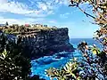
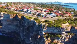 Clifftop homes in Vaucluse
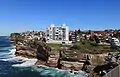 Houses and apartments line the cliff top in Dover Heights
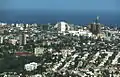 View of Bondi Junction from Sydney Tower
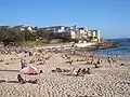 North Bondi Beach
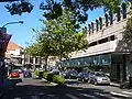 Knox Street, Double Bay
 Typical clifftop neighbourhood
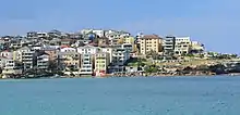 North Bondi suburb
Sporting team
Sydney's Eastern Suburbs are represented in one of the most popular sporting competitions in Australia, the National Rugby League, by the Eastern Suburbs District Rugby League Football Club, the Sydney Roosters. The Roosters have represented Sydney's east as its flagship team in a major sporting premiership, since the establishment of the club at the Paddington Town Hall in 1908. They have represented the Eastern Suburbs with great success, winning 15 premierships, with back to back wins in 2018 and 2019.
References
- Australian Bureau of Statistics (27 June 2017). "Sydney - Eastern Suburbs". 2016 Census QuickStats. Retrieved 17 July 2017.

- "Sydney East - Plan a Holiday - Watsons Bay, Bondi, Coogee & La Perouse". Retrieved 27 August 2018.
- Australian Bureau of Statistics (31 October 2012). "Sydney – Eastern Suburbs". 2011 Census QuickStats. Retrieved 27 January 2014.
- Australian Bureau of Statistics (25 October 2007). "Eastern Suburbs (Statistical Subdivision)". 2006 Census QuickStats. Retrieved 7 March 2009.