City of Randwick
The City of Randwick is a local government area in the eastern suburbs of Sydney, New South Wales, Australia. Established in 1859, Randwick is the second-oldest local government area in New South Wales, after the City of Sydney. It comprises an area of 36 square kilometres (14 sq mi) and as at the 2016 census had a population of 140,660.[1]
| City of Randwick New South Wales | |||||||||||||||
|---|---|---|---|---|---|---|---|---|---|---|---|---|---|---|---|
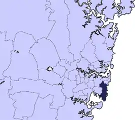 Location in Metropolitan Sydney | |||||||||||||||
| Coordinates | 33°55′S 151°15′E | ||||||||||||||
| Population |
| ||||||||||||||
| • Density | 3,910/km2 (10,120/sq mi) | ||||||||||||||
| Established | 23 February 1859 | ||||||||||||||
| Area | 36 km2 (13.9 sq mi) | ||||||||||||||
| Mayor | Danny Said | ||||||||||||||
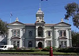
| Council seat | Randwick Town Hall | ||||||||||||||
| Region | Metropolitan Sydney | ||||||||||||||
| State electorate(s) | |||||||||||||||
| Federal Division(s) | |||||||||||||||
| Website | City of Randwick | ||||||||||||||
| |||||||||||||||
The Mayor of the City of Randwick is Cr. Danny Said, a member of NSW Labor, who was elected on 25 September 2019.[3]
Suburbs and localities in the local government area
Suburbs and localities in the City of Randwick are:
- Centennial Park (most is located in City of Sydney council)
- Chifley
- Clovelly (minor part located in Waverley Council)
- Coogee
- Coogee Beach
- Kensington
- Kingsford
- La Perouse
- Little Bay
- Malabar
- Maroubra
- Maroubra Junction
- Matraville (minor part located in Bayside Council)
- Pagewood (most is located in Bayside Council)
- Phillip Bay
- Port Botany
- Randwick
- South Coogee
- University of New South Wales
These localities are also serviced by Randwick Council:
History
Indigenous Australian history in the area dates back tens of thousands of years. The local people at the time of colonisation were the Cadigal of the Dharug language group. European settlement led to the deaths of many Cadigal via introduced diseases or in conflict with settlers. The surviving Cadigal left the area or were pushed to the fringes of settlement. By the mid-nineteenth century, the original tribal groupings had been effectively destroyed.
The name Randwick comes from the village of Randwick in Gloucestershire, England, birthplace of the district's first mayor Simeon Henry Pearce. The area was home to a few wealthy landowners and the poor residents of several shantytowns until the 1880s, when the coming of trams from Sydney brought extensive suburban development. This development continued steadily, with new tram lines (long since demolished) opening up most of the city for subdivision by the early 1900s. The New South Wales University of Technology opened at Kensington in 1949 on the site of Kensington Racecourse, eventually becoming the University of New South Wales.
A 2015 review of local government boundaries recommended that the City of Randwick merge with the Waverley and Woollahra councils to form a new council with an area of 58 square kilometres (22 sq mi) and support a population of approximately 274,000.[4] Following an independent review, in May 2016 the NSW Government sought to dismiss the Council and force its amalgamation with Woollahra and Waverley councils. Woollahra Council instigated legal action claiming that there was procedural unfairness and that a KPMG report at the centre of merger proposals had been "misleading". The matter was heard before the NSW Court of Appeal who, in December 2016, unanimously dismissed Woollahra Council's appeal, finding no merit in its arguments that the proposed merger with Waverley and Randwick councils was invalid.[5] In July 2017, the Berejiklian government decided to abandon the forced merger of the Woollahra, Waverley and Randwick local government areas, along with several other proposed forced mergers.[6]
Town Clerks and General Managers
| Name | Term | Notes |
|---|---|---|
| Ernest Henry Strachan | 12 May 1898 – 1912 | [7] |
| William Kirby Percival | 8 February 1912 – | [8] |
| Richard Thomas Latham | 1938 – 1963 | [9] |
| R. A. Woodward | 1963 – 1982 | [10] |
| Geoff J. Rose | 1982 – 1991 | [11] |
| A. V. Burgess | 1991 – 1997 | [12] |
| Gordon Messiter | 1997 – July 2004 | [13] |
| Ray Brownlee | 2004 – 28 September 2018 | [14] |
| Therese Manns | 1 November 2018 – present | [15] |
Demographics
At the 2016 census, there were 140,660 people in the Randwick local government area, of these 49.2% were male and 50.8% were female. Aboriginal and Torres Strait Islander people made up 1.5% of the population; significantly below the NSW and Australian averages of 2.9 and 2.8 per cent respectively. The median age of people in the City of Randwick was 34 years. Children aged 0–14 years made up 14.9% of the population and people aged 65 years and over made up 13.4% of the population. Of people in the area aged 15 years and over, 38.5% were married and 9.1% were either divorced or separated.[1]
Population growth in the City of Randwick between the 2001 Census and the 2006 census was 1.10%; and in the subsequent five years to the 2011 census, population growth was 7.59%. When compared with total population growth of Australia for the same periods, being 5.78% and 8.32% respectively, population growth in Randwick local government area was lower than the national average.[16] The median weekly income for residents within the City of Randwick was higher than the national average.[17][18]
| Selected historical census data for Randwick local government area | ||||||
|---|---|---|---|---|---|---|
| Census year | 2001[16] | 2006[18] | 2011[17] | 2016[1] | ||
| Population | Estimated residents on census night | 118,580 | 119,884 | 128,989 | 140,660 | |
| LGA rank in terms of size within New South Wales | 19th | |||||
| % of New South Wales population | 1.90% | |||||
| % of Australian population | 0.63% | |||||
| Estimated ATSI population on census night | 1,351 | 1,474 | 1,842 | 2,144 | ||
| % of ATSI population to residents | 1.1% | |||||
| Cultural and language diversity | ||||||
| Ancestry, top responses | Australian | 17.5% | ||||
| English | 18.5% | |||||
| Chinese | 9.4% | |||||
| Irish | 9.2% | |||||
| Scottish | 4.9% | |||||
| Language, top responses (other than English) | Mandarin | 2.7% | ||||
| Greek | 4.8% | |||||
| Cantonese | 4.2% | |||||
| Indonesian | 2.6% | |||||
| Spanish | n/c | n/c | ||||
| Religious affiliation | ||||||
| Religious affiliation, top responses | Catholic | 31.6% | ||||
| No religion | 14.6% | |||||
| Anglican | 15.6% | |||||
| Eastern Orthodox | 7.3% | |||||
| Judaism | n/c | n/c | ||||
| Median weekly incomes | ||||||
| Personal income | Median weekly personal income | A$593 | A$718 | A$834 | ||
| % of Australian median income | 127.3% | |||||
| Family income | Median weekly family income | A$1,185 | A$2,066 | A$2,421 | ||
| % of Australian median income | 115.4% | |||||
| Household income | Median weekly household income | A$1,579 | A$1,577 | A$1,916 | ||
| % of Australian median income | 134.8% | |||||
| Dwelling structure | ||||||
| Dwelling type | Separate house | 30.2% | ||||
| Semi-detached, terrace or townhouse | 15.8% | |||||
| Flat or apartment | 51.7% | |||||
Council
| Mayor | Term | Notes | |
|---|---|---|---|
| Mayor | Danny Said | 25 September 2019 – date | [3] |
| Deputy Mayor | Philipa Veitch | 25 September 2019 – date | [3] |
| General Manager | Term | Notes | |
| Ray Brownlee | 2004 – 28 September 2018 | [14] | |
| Therese Manns | 1 November 2018 – date | GM, City of Broken Hill, Boorowa Shire.[15] | |
Current composition and election method
Randwick City Council is composed of fifteen Councillors elected proportionally as five separate wards,[19] each electing three Councillors. All Councillors are elected for a fixed four-year term of office. The Mayor is elected for a two-year term, with the Deputy Mayor for one year, by the Councillors at the first meeting of the Council. The most recent election was held on 9 September 2017, and the makeup of the Council is as follows:[20][21][22][23][24]

| Party | Councillors | |
|---|---|---|
| Australian Labor Party | 5 | |
| Liberal Party of Australia | 4 | |
| Independents | 3 | |
| Greens NSW | 3 | |
| Total | 15 | |
The current Council, elected in 2017, in order of election by ward, is:
| Ward | Councillor | Party | Notes | |
|---|---|---|---|---|
| Central Ward[20] | Dylan Parker | Labor | Elected 2017. | |
| Ted Seng | Liberal | Elected 1995. Mayor 2005–2006 2014–2015, Deputy Mayor 1996–1997 | ||
| Anthony Andrews | Independent | Elected 2001. Deputy Mayor 2013–2015 | ||
| East Ward[21] | Brendan Roberts | Liberal | Elected 2012. Deputy Mayor 2016–2017 | |
| Tony Bowen | Labor | Elected 2008. Mayor 2012–2013 | ||
| Murray Matson | Greens | Elected 1995. Mayor 2004–2005 2010–2011, Deputy Mayor 2005–2008 | ||
| North Ward[22] | Christie Hamilton | Liberal | Elected 2017. | |
| Kathy Neilson | Labor | Elected 2012. Mayor 2018–2019[3] | ||
| Lindsay Shurey | Greens | Elected 2012. Mayor 2017–2018[25][26] | ||
| South Ward[23] | Noel D'Souza | Independent | Elected 2012. Mayor 2015–2017, Deputy Mayor 2012–2013 | |
| Carlos Da Rocha | Independent | Elected 2017 on Noel D'Souza's ticket. | ||
| Danny Said | Labor | Elected 2017. Deputy Mayor 2018–2019, Mayor 2019–date[3] | ||
| West Ward[24] | Harry Stavrinos | Liberal | Elected 2012. | |
| Alexandra Luxford | Labor | Elected 2017. Deputy Mayor 2017–2018[25] | ||
| Philipa Veitch | Greens | Elected 2017, Deputy Mayor 2019–date | ||
Heritage listings
The City of Randwick has a number of heritage-listed sites, including those listed under the New South Wales Heritage Register:
- Centennial Park, 3R Oxford Street: Centennial Park Reservoir[27]
- Centennial Park, 5R Oxford Street: Woollahra Reservoir[28]
- Coogee, 45-51 Beach Street: Cliffbrook[29]
- Coogee, Grant Reserve: McIver Women's Baths[30]
- Coogee, 4b Neptune Street: Wylie's Baths[31]
- Kensington, 85 Todman Avenue: Carthona (Kensington)[32]
- La Perouse, Bare Island Fort[33]
- La Perouse, 46 Adina Avenue: La Perouse Mission Church[34]
- La Perouse, 1-39 Bunnerong Road: Chinese Market Gardens (La Perouse)[35]
- Little Bay, 1430 Anzac Parade: Prince Henry Site[36]
- Malabar, 1250 Anzac Parade: Long Bay Correctional Centre[37]
- Malabar, Franklin Street: Malabar Headland[38]
- Randwick, Centennial Park, Moore Park, Queens Park[39]
- Randwick, 124 Alison Road: Randwick Post Office[40]
- Randwick, 162 Alison Road: Randwick Presbyterian Church[41]
- Randwick, 102-108 Avoca Street: St Jude's Church, Randwick[42]
- Randwick, 211-215 Avoca Street: Corana and Hygeia[43][44][45]
- Randwick, 128 Belmore Road: Sandgate (Randwick)[46]
- Randwick, 60 Bundock Lane: Electricity Substation No. 341[47]
- Randwick, 66 Frenchmans Road: Venice (Randwick)[48]
- Randwick, 17 Gilderthorpe Avenue: Hooper Cottage[49]
- Randwick, 16-18 Milford Street: Nugal Hall[50]
- Randwick, 2S Frances Street: Electricity Substation No. 349[51]
- Randwick, 43 St Marks Road: Rathven (Randwick)[52]
- Randwick, 43 St Pauls Street: Ritz Cinema, Sydney[53]
- Randwick, 18-20 Stanley Street: Emanuel School, Australia[54]
- Randwick, 26-42 The Avenue: Avonmore Terrace[55]
- Randwick, 29-39 Young Street: Big Stable Newmarket[56]
References
- Australian Bureau of Statistics (27 June 2017). "Randwick (C)". 2016 Census QuickStats. Retrieved 5 July 2017.

- "3218.0 – Regional Population Growth, Australia, 2017-18". Australian Bureau of Statistics. 27 March 2019. Retrieved 27 March 2019. Estimated resident population (ERP) at 30 June 2018.
- "Councillors Kathy Neilson and Danny Said elected new Mayor and Deputy Mayor of Randwick" (Media Release). Randwick City Council. 26 September 2018. Retrieved 29 September 2018.
- "Merger proposal: Randwick City Council, Waverley Council, Woollahra Municipal Council" (PDF). Government of New South Wales. January 2016. p. 7. Retrieved 4 March 2016.
- Visentin, Lisa (22 December 2016). "Woollahra loses merger appeal, hints at High Court challenge". The Sydney Morning Herald. Retrieved 31 December 2016.
- Blumer, Clare; Chettle, Nicole (27 July 2017). "NSW council amalgamations: Mayors fight to claw back court dollars after backflip on merger". ABC News. Australia. Retrieved 27 July 2017.
- "BOROUGH OF RANDWICK". New South Wales Government Gazette (420). New South Wales, Australia. 17 May 1898. p. 3782. Retrieved 28 March 2019 – via National Library of Australia.
- "MUNICIPALITY OF RANDWICK". Government Gazette of the State of New South Wales (24). New South Wales, Australia. 14 February 1912. p. 1215. Retrieved 28 March 2019 – via National Library of Australia.
- "Park Names". Randwick City Council. Retrieved 2 March 2019.
- "RANDWICK MUNICIPAL COUNCIL.—Local Government Act, 1919 (Section 269A).—Ordinance No. 30, Clause 55A.—". Government Gazette of the State of New South Wales (73). New South Wales, Australia. 22 May 1981. p. 2842. Retrieved 2 March 2019 – via National Library of Australia.
- "RANDWICK MUNICIPAL COUNCIL.—Local Government Act, 1919 (Section 269A).—Ordinance No. 30, Clause 55A.—". Government Gazette of the State of New South Wales (179). New South Wales, Australia. 24 December 1982. p. 6012. Retrieved 2 March 2019 – via National Library of Australia.
- "RANDWICK CITY COUNCIL". Government Gazette of the State of New South Wales (57). New South Wales, Australia. 12 May 1995. p. 2444. Retrieved 2 March 2019 – via National Library of Australia.
- "Messiter calls it a day". Southern Courier. 6 July 2004. p. 4.
- "Ray Brownlee appointed new Chief Executive Officer" (Media Release). Northern Beaches Council. 17 July 2018. Retrieved 19 July 2018.
- "Therese Manns appointed Randwick Council General Manager" (Press release). Randwick City Council. 26 September 2018. Retrieved 29 September 2018.
- Australian Bureau of Statistics (9 March 2006). "Randwick (C)". 2001 Census QuickStats. Retrieved 5 November 2012.
- Australian Bureau of Statistics (31 October 2012). "Randwick (C)". 2011 Census QuickStats. Retrieved 5 November 2012.
- Australian Bureau of Statistics (25 October 2007). "Randwick (C)". 2006 Census QuickStats. Retrieved 5 November 2012.
- "Randwick City Council: Wards and Suburbs". City of Randwick. September 2008. Archived from the original (PDF) on 23 February 2012. Retrieved 19 September 2012.
- "City of Randwick - Central Ward". NSW Local Council Elections 2017. NSW Electoral Commission. Retrieved 15 September 2017.
- "City of Randwick - East Ward". NSW Local Council Elections 2017. NSW Electoral Commission. Retrieved 15 September 2017.
- "City of Randwick - North Ward". NSW Local Council Elections 2017. NSW Electoral Commission. Retrieved 15 September 2017.
- "City of Randwick - South Ward". NSW Local Council Elections 2017. NSW Electoral Commission. Retrieved 15 September 2017.
- "City of Randwick - West Ward". NSW Local Council Elections 2017. NSW Electoral Commission. Retrieved 15 September 2017.
- Hogg, Marie (26 September 2017). "DEAL DONE, GREENS GET RANDWICK COUNCIL MAYORALTY". Southern Courier. Retrieved 28 September 2017.
- "Randwick Council elects all-female leadership team for next 12 months" (Media Release). City of Randwick. 26 September 2017. Retrieved 28 September 2017.
- "Centennial Park Reservoir WS001". New South Wales State Heritage Register. Office of Environment and Heritage. H01320. Retrieved 18 May 2018.
- "Woollahra Reservoir WS022". New South Wales State Heritage Register. Office of Environment and Heritage. H01356. Retrieved 18 May 2018.
- "Cliffbrook". New South Wales State Heritage Register. Office of Environment and Heritage. H00609. Retrieved 18 May 2018.
- "McIver Women's Baths". New South Wales State Heritage Register. Office of Environment and Heritage. H01869. Retrieved 18 May 2018.
- "Wylie's Baths". New South Wales State Heritage Register. Office of Environment and Heritage. H01677. Retrieved 18 May 2018.
- "Carthona". New South Wales State Heritage Register. Office of Environment and Heritage. H00555. Retrieved 18 May 2018.
- "Bare Island Fort". New South Wales State Heritage Register. Office of Environment and Heritage. H00978. Retrieved 18 May 2018.
- "La Perouse Mission Church". New South Wales State Heritage Register. Office of Environment and Heritage. H01893. Retrieved 18 May 2018.
- "Chinese Market Gardens". New South Wales State Heritage Register. Office of Environment and Heritage. H01299. Retrieved 18 May 2018.
- "Prince Henry Site". New South Wales State Heritage Register. Office of Environment and Heritage. H01651. Retrieved 18 May 2018.
- "Long Bay Correctional Centre". New South Wales State Heritage Register. Office of Environment and Heritage. H00810. Retrieved 18 May 2018.
- "Malabar Headland". New South Wales State Heritage Register. Office of Environment and Heritage. H01741. Retrieved 18 May 2018.
- "Centennial Park, Moore Park, Queens Park". New South Wales State Heritage Register. Office of Environment and Heritage. H01384. Retrieved 18 May 2018.
- "Randwick Post Office (former) and Jubilee Fountain". New South Wales State Heritage Register. Office of Environment and Heritage. H01409. Retrieved 18 May 2018.
- "Randwick Presbyterian Church". New South Wales State Heritage Register. Office of Environment and Heritage. H01777. Retrieved 18 May 2018.
- "St. Jude's Anglican Church, Cemetery, Rectory, Vergers Residence". New South Wales State Heritage Register. Office of Environment and Heritage. H00012. Retrieved 18 May 2018.
- "Corana and Hygeia". New South Wales State Heritage Register. Office of Environment and Heritage. H00454. Retrieved 18 May 2018.
- The Lurline Randwick
- walkingcoastalsydney.com.au
- "Sandgate". New South Wales State Heritage Register. Office of Environment and Heritage. H00067. Retrieved 18 May 2018.
- "Substation". New South Wales State Heritage Register. Office of Environment and Heritage. H00935. Retrieved 18 May 2018.
- "Venice". New South Wales State Heritage Register. Office of Environment and Heritage. H00175. Retrieved 18 May 2018.
- "Hooper Cottage". New South Wales State Heritage Register. Office of Environment and Heritage. H00087. Retrieved 18 May 2018.
- "Nugal Hall". New South Wales State Heritage Register. Office of Environment and Heritage. H00173. Retrieved 18 May 2018.
- "Electricity Substation No. 349". New South Wales State Heritage Register. Office of Environment and Heritage. H01792. Retrieved 18 May 2018.
- "Rathven". New South Wales State Heritage Register. Office of Environment and Heritage. H00139. Retrieved 18 May 2018.
- "Ritz Theatre". New South Wales State Heritage Register. Office of Environment and Heritage. H00348. Retrieved 18 May 2018.
- "Emanuel School". New South Wales State Heritage Register. Office of Environment and Heritage. H00386. Retrieved 18 May 2018.
- "Avonmore Terrace". New South Wales State Heritage Register. Office of Environment and Heritage. H00565. Retrieved 18 May 2018.
- "Big Stable Newmarket". New South Wales State Heritage Register. Office of Environment and Heritage. H00388. Retrieved 18 May 2018.
External links
| Wikimedia Commons has media related to City of Randwick. |