South Glengarry, Ontario
South Glengarry is a township in eastern Ontario, Canada on the Saint Lawrence River in the United Counties of Stormont, Dundas and Glengarry.
South Glengarry | |
|---|---|
| Township of South Glengarry | |
 Lancaster | |
 South Glengarry | |
| Coordinates: 45°12′N 74°35′W | |
| Country | |
| Province | |
| County | Stormont, Dundas and Glengarry |
| Settled | 1785 |
| Incorporated | 1792 (Royal Townships) |
| Incorporated | 1998 (South Glengarry) |
| Government | |
| • Type | Township |
| • Mayor | Frank Prevost |
| • Federal riding | Stormont—Dundas—South Glengarry |
| • Prov. riding | Stormont—Dundas—South Glengarry |
| Area | |
| • Land | 605.36 km2 (233.73 sq mi) |
| Population (2016)[1] | |
| • Total | 13,150 |
| • Density | 21.7/km2 (56/sq mi) |
| Time zone | UTC−5 (EST) |
| • Summer (DST) | UTC−4 (EDT) |
| Postal code FSA | K0C |
| Area code(s) | 613 |
| Website | southglengarry.com |
Communities
The township of South Glengarry comprises a number of villages and hamlets, including the following communities:
- Charlottenburgh Township: Glen Walter, Green Valley, Martintown, Summerstown, Summerstown Station, St. Raphaels, Williamstown; Avondale, Cashions Glen, Glen Brook, Glendale, Glen Falloch, Glenroy, MacGillivrays Bridge, Munroes Mills, Tyotown; Bayview Estates, Glendale Subdivision, Glen Gordon, Loon Island, North Branch; Camerons Point, Danis Point, Farlingers Point, Flannigans Point, Fraser Point, McGibbons Point, Pilons Point, Prevost Point, Stonehouse Point
- Lancaster Township: Bainsville, Brown House Corner, Dalhousie Mills, Glen Nevis, Glen Norman, Lancaster, North Lancaster, South Lancaster; Bridge End, Curry Hill, Pine Hill; Lancaster Heights, Maple Hill, North Lancaster Station, Picnic Grove, Redwood Estates; Brittania Point, Creg Quay, Faulkners Point, Nadeaus Point, Pointe Mouillee, Westleys Point
The township administrative offices are located in Lancaster.
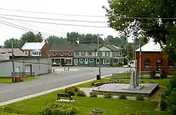
 Martintown
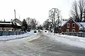
 Williamstown
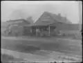 James Clyde's Blacksmith and Farrier Shop (right) and Farm Implement Sales Shop (left), [between 1895 and 1910]
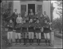
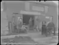 Daniel Columbus McArthur Blacksmith Shop, [between 1895 and 1910]
History
Charlottenburgh and Lancaster were two of the original eight "Royal Townships", established along the Saint Lawrence River in Upper Canada in the 1780s. This area was first settled by United Empire Loyalists. The development of this area was encouraged by Sir John Johnson, then the Superintendent General and Inspector General of Indian Affairs, who had been forced to abandon his land holdings in New York State during the American Revolution.[2]
From the late 18th century to the early 19th century, the area was almost entirely settled by Scottish highlanders, especially from Inverness-shire, after the Highland Clearances. Canadian Gaelic / Scottish Gaelic had been spoken in Glengarry County since its first settlement in 1784.
Sir John built a house in Williamstown which was completed in 1785 and is now a Canadian National Historic Site, the Sir John Johnson Manor House. A grist mill and saw mill, now gone, were also built on the same location. Williamstown also has the oldest house in Ontario, The Bethune-Thompson House built in 1784. Occupants over the years have included the Reverend John Bethune (1751–1815), the great-great-grandfather of Doctor Norman Bethune, and David Thompson, Canadian explorer.
Some of the main partners of the North West Company, including Hugh McGillis, lived in this area.
Alexander McMartin, the first person born in Upper Canada to serve in the Legislative Assembly, was from Martintown.
The Glengarry Celtic Music Hall of Fame is located in Williamstown.
Williamstown is also home to Ontario’s oldest continuing annual fair, which celebrated its bicentennial in 2012. (North America’s oldest being the Hants County agricultural exhibition of Windsor, Nova Scotia, some 47 years older, est. 1765)
The Nor'Westers and Loyalist Museum is also located in Williamstown.
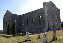
South Glengarry is the location of four National Historic Sites of Canada: the Bethune-Thompson House,[3] the Glengarry Cairn,[4] the Sir John Johnson House,[5] and the ruins of St. Raphael's Roman Catholic Church.[6]
St. Raphael's Catholic Church was built commencing 1821 under the authority of Alexander Macdonell later Bishop of Regiopolis (now Kingston, Ontario). This is one of the oldest churches in what was then the colony of Upper Canada. In late 1970, the church interiors, roof and tower were destroyed by fire, but the ruins were preserved. In 1973, a smaller church with the same name was built, attached to the ruins .
The township was established on January 1, 1998, with the amalgamation of the former Townships of Charlottenburgh and Lancaster, along with the Village of Lancaster.
Demographics
| Year | Pop. | ±% |
|---|---|---|
| 1986 | 10,946 | — |
| 1991 | 11,971 | +9.4% |
| 1996 | 12,649 | +5.7% |
| 2001 | 12,700 | +0.4% |
| 2006 | 12,880 | +1.4% |
| 2011 | 13,162 | +2.2% |
| 2016 | 13,150 | −0.1% |
| Population amounts prior to 2001 is total of Charlottenburgh TP, Lancaster TP, and Lancaster VL. | ||
| Canada census – South Glengarry, Ontario community profile | |||
|---|---|---|---|
| 2016 | 2011 | 2006 | |
| Population: | 13,150 (-0,1% from 2011) | 13,162 (2.2% from 2006) | 12,880 (1.4% from 2001) |
| Land area: | 605.36 km2 (233.73 sq mi) | 605.30 km2 (233.71 sq mi) | 604.91 km2 (233.56 sq mi) |
| Population density: | 21.7/km2 (56/sq mi) | 21.7/km2 (56/sq mi) | 21.3/km2 (55/sq mi) |
| Median age: | 49.9 (M: 49.6, F: 50.1) | 47.7 (M: 47.3, F: 48.1) | 44.8 (M: 44.5, F: 45.1) |
| Total private dwellings: | 5823 | 5616 | 5277 |
| Median household income: | $76,702 | $62,120 | |
| References: 2016[1] 2011[7] 2006[8] earlier[9] | |||
Culture
Canadian author Hugh Hood mentions Williamstown in his short story "Getting to Williamstown," first published in 1928.
Sport
The Char-Lan Rebels of the CCHL2 League play out of the Char-Lan Recreation Centre in Williamstown.
Notable people
- Sir John Johnson, one of the original landowners and developers of the area. Constructed The Manor House in Williamstown, now a Canadian National Historic Site.
- James Leroy (1947-1979), nationally recognized songwriter, performer and recording artist; spent his childhood and adolescence in Martintown.
- Alexander Macdonell, later Bishop of Regiolopolis (now Kingston, Ontario).
- Ran McDonald, hockey player, born in Cashion's Glen and played in the PCHA reaching the height of his career in the 1919 Stanley Cup Finals.
- Hugh McGillis, partner in the North West Company
- Alexander McMartin, from Martintown; first person born in Upper Canada to serve in the Legislative Assembly.
- David Thompson, resident of Williamstown; Canadian explorer.
References
- "2016 Community Profiles". 2016 Canadian Census. Statistics Canada. February 21, 2017. Retrieved 2019-10-22.
- assnat.qc.ca: "John JOHNSON (1741-1830)"
- Bethune-Thompson House / White House. Canadian Register of Historic Places.
- Glengarry Cairn, Directory of Designations of National Historic Significance of Canada
- Sir John Johnson House. Canadian Register of Historic Places.
- Ruin of St. Raphael's Roman Catholic Church. Canadian Register of Historic Places.
- "2011 Community Profiles". 2011 Canadian Census. Statistics Canada. July 5, 2013. Retrieved 2012-02-27.
- "2006 Community Profiles". 2006 Canadian Census. Statistics Canada. March 30, 2011. Retrieved 2012-02-27.
- "2001 Community Profiles". 2001 Canadian Census. Statistics Canada. February 17, 2012.
External links
| Wikimedia Commons has media related to South Glengarry, Ontario. |
Places adjacent to South Glengarry, Ontario | |
|---|---|