South Stormont
South Stormont is a township in eastern Ontario, Canada, in the United Counties of Stormont, Dundas and Glengarry. It is located 53 kilometres (33 mi) southeast of Ottawa. South Stormont borders on, but does not include, the city of Cornwall.
South Stormont | |
|---|---|
| Township of South Stormont | |
 Community of St. Andrews West | |
 South Stormont | |
| Coordinates: 45°05′N 74°58′W | |
| Country | Canada |
| Province | Ontario |
| County | Stormont, Dundas and Glengarry |
| Formed | January 1, 1998 |
| Government | |
| • Type | Township |
| • Mayor | Bryan McGillis |
| • Deputy Mayor | David Smith |
| • Federal riding | Stormont—Dundas—South Glengarry |
| • Prov. riding | Stormont—Dundas—South Glengarry |
| Area | |
| • Land | 447.58 km2 (172.81 sq mi) |
| Population (2016)[1] | |
| • Total | 13,110 |
| • Density | 28.2/km2 (73/sq mi) |
| Time zone | UTC-5 (Eastern (EST)) |
| • Summer (DST) | UTC-4 (Eastern Daylight (EDT)) |
| Postal code FSA | K0C |
| Area code(s) | 613 |
| Website | www.southstormont.ca |
Communities
The township of South Stormont comprises a number of villages and hamlets, including the following communities:
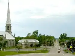
- Cornwall Township: Beaver Glen, Bonville, Harrison's Corners, Long Sault, Northfield, Rosedale Terrace, St. Andrews West; Black River, McMillans Corners (partially), Sandfield Mills; Churchill Heights, Northfield Station, Lakeview Heights,
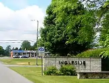
- Osnabruck Township: Ingleside, Lunenburg, Newington, Osnabruck Centre; Ault Island, Bush Glen, Bunker Hill, Dixon, Gallingertown, North Lunenburg, North Valley, Pleasant Valley, Sandtown; Cedar Grove,
In addition, the township would have been home to the nine Lost Villages which were flooded to create the St. Lawrence Seaway:
- Maple Grove, Mille Roches, Moulinette, Sheek's Island in Cornwall Township
- Aultsville, Dickinson's Landing, Farran's Point, Santa Cruz, Wales, Woodlands in Osnabruck Township
Local government
The township of South Stormont is governed by three councillors, a deputy mayor and a mayor (reeve). The term length is four years. South Stormont also conducts elections on the internet, using a secure, cost-efficient website and an automated telephone voting system.[2]
- Mayor - Bryan McGillis
- Deputy Mayor - David Smith
- Councillor - Andrew Guindon
- Councillor - Jennifer MacIsaac
- Councillor - Cindy Woods
The South Stormont Town Hall and administrative offices are located in Long Sault.[2]
History
Cornwall and Osnabruck were two of the original eight "Royal Townships" established along the Saint Lawrence River in Upper Canada. Cornwall was named for King George III's eldest son, Prince George, Prince of Wales, who also held the title of Duke of Cornwall. Osnabruck was named after a title formerly held by the King's second son, Prince Frederick, who at one time was Prince-Bishop of Osnabrück in Lower Saxony.
This area was first settled by members of Sir John Johnson's King's Royal Regiment of New York, and became Stormont County in 1792.
The Lost Villages, ten ghost towns which were flooded by the construction of the Saint Lawrence Seaway in 1958, were located in the former Cornwall and Osnabruck Townships. The communities of Long Sault and Ingleside were newly built to accommodate displaced residents of the flooded villages. Due to this relocation, the towns were entirely planned from their inception – a rarity in Ontario. Several streets in the two communities are named for the flooded settlements.
The township was established on January 1, 1998, with the amalgamation of the former Townships of Cornwall and Osnabruck. Jim Brownell was its first reeve.[3]
Demographics
| Year | Pop. | ±% |
|---|---|---|
| 1986 | 9,479 | — |
| 1991 | 11,008 | +16.1% |
| 1996 | 11,584 | +5.2% |
| 2001 | 11,941 | +3.1% |
| 2006 | 12,520 | +4.8% |
| 2011 | 12,617 | +0.8% |
| 2016 | 13,110 | +3.9% |
| Population amounts prior to 2001 is total of Cornwall TP and Osnabruck TP. | ||
| Canada census – South Stormont community profile | |||
|---|---|---|---|
| 2016 | 2011 | ||
| Population: | 13,110 (3.9% from 2011) | 12,617 (0.8% from 2006) | |
| Land area: | 447.58 km2 (172.81 sq mi) | 447.50 km2 (172.78 sq mi) | |
| Population density: | 29.3/km2 (76/sq mi) | 28.2/km2 (73/sq mi) | |
| Median age: | 46.8 (M: 45.6, F: 47.8) | 45.5 (M: 45.1, F: 45.9) | |
| Total private dwellings: | 5277 | 4991 | |
| Median household income: | $76,092 | ||
| References: 2016[4] 2011[5] earlier[6] | |||
Notable residents
- Burial place of Simon Fraser, famous Canadian explorer.
References
- "South Stormont census profile". 2016 Census of Population. Statistics Canada. Retrieved 2017-09-02.
- "Mayor and Council". southstormont.ca. Township of South Stormont. Retrieved 21 October 2019.
- "Facts & Trivia". southstormont.ca. Township of South Stormont. Retrieved 21 October 2019.
- "2016 Community Profiles". 2016 Canadian Census. Statistics Canada. February 21, 2017. Retrieved 2017-09-02.
- "2011 Community Profiles". 2011 Canadian Census. Statistics Canada. July 5, 2013. Retrieved 2012-02-27.
- "2001 Community Profiles". 2001 Canadian Census. Statistics Canada. February 17, 2012.
External links
| Wikimedia Commons has media related to South Stormont, Ontario. |
Places adjacent to South Stormont | |
|---|---|