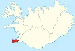
Southern Peninsula (Iceland)
Southern Peninsula (Icelandic: Suðurnes) is an administrative unit and part of Reykjanesskagi (pronounced [ˈreiːcanɛsˌskaiːjɪ]), or Reykjanes Peninsula, a region in southwest Iceland. It was named after Reykjanes, the southwestern tip of Reykjanesskagi.[1]
Suðurnes | |
|---|---|
 The Suðurnes area | |
| Country | Iceland |
| Seat | Keflavík |
| Area | |
| • Total | 829 km2 (320 sq mi) |
| Population (2020) | |
| • Total | 27,829 |
| • Density | 24.5/km2 (63/sq mi) |
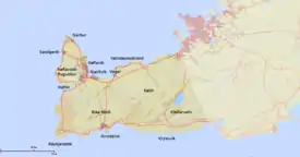
The region has a population of 27,829 (2020) and is one of the more densely populated parts of the island. The administrative centre is Keflavík, which had 7,000 residents when it merged with the nearby town of Njarðvík and Hafnir several years ago to create Reykjanesbær, which now (feb 2019) is the largest settlement outside the Greater Reykjavík area; on 1 January 2013 the town had a population of 14,231, but 17,805 in 2018.[2]
The region is the location of Keflavík International Airport, the major point of entry for Iceland, and also the Blue Lagoon health spa.[3]
The peninsula is marked by active volcanism under its surface, and large lava fields, allowing little vegetation. There are numerous hot springs and sulphur springs in the southern half of the peninsula, around the Kleifarvatn lake and the Krýsuvík geothermal area.[4]
There is also a geothermal power station at Svartsengi. Near the power station a luxury spa and pool area has been installed using the hot and mineralized water coming down from the power station; it is known as the "Blue Lagoon" (Bláa Lónið).[5]
The Bridge Between Continents spans the Álfagjá rift valley (60 feet wide and 20 feet (6.1 m) deep) near Grindavik, which marks the boundary of the Eurasian and North American continental tectonic plates. It was built in 2002 and previously named Leif the Lucky bridge in honor of Icelandic explorer Leif Eriksson who traveled from Europe to America nearly 500 years before Christopher Columbus.[6]
Some fishing towns, such as Grindavík, Njarðvík and Sandgerði are situated on the peninsula as well as the town of Keflavík, the site of Keflavík International Airport and the Leifur Eriksson Air Terminal and the former American military base.[7]
Reykjanes volcanic system
| Reykjanes (volcanic system) | |
|---|---|
%252C_Reykjanes_peninsula.JPG.webp) The Reykjanes volcanic system is almost completely covered by Holocene-age lava fields. | |
| Highest point | |
| Elevation | 230 m (754 ft) |
| Coordinates | 63°52′12″N 22°33′30″W |
| Geography | |
| Location | Reykjanes Peninsula, Iceland |
| Parent range | Mid-Atlantic Ridge |
| Geology | |
| Mountain type | Crater rows |
| Last eruption | 1926 (submarine) |
The Reykjanes Volcanic System is one of the volcanic systems on Reykjanes Peninsula in Southwest Iceland, where the Mid-Atlantic Ridge rises above sea level. It is part of Reykjanes Volcanic Belt like the 3-6 (depending on author) other volcanic systems on Reykjanes Peninsula (see eg. Th. Thordarson, A. Hoskuldsson[8] or the Catalogue of Icelandic Volcanoes[9]or Icelandic Met Office[10] resp. J.M.Verbeugt [11]).
A volcanic system on the peninsula of Reykjanes consists of (volcanic and tectonic) fissures and faults directed mostly NE-SW. Only Hengill, if this volcano is also taken into account here, has an additional central volcano.[12][13]
The Reykjanes volcanic system shows lava fields and postglacial basaltic crater rows. The small shield volcanoes are mostly not counted with. [14]
The submarine Reykjanes Ridge volcanic zone is contiguous, but is considered only for a small part integrated into the Reykjanes volcanic system, which is the westernmost of a series of four (to six, see above) closely spaced en-echelon fissure systems extending across the Reykjanes Peninsula. The highest of the system's multiple vents is 230 metres (754 ft). Dredging operations resulted in recovery of basaltic rocks of probable Holocene age. Most of the subaerial part of the system is covered by Holocene-age lava fields. During the 13th century, the last subaerial eruptions occurred along the Reykjanes fissure system. Tephra deposits from Holocene eruptions have been preserved on the Reykjanes Peninsula.
Gallery
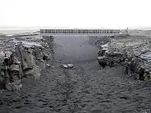 Leif the Lucky Bridge spanning the Álfagjá rift valley
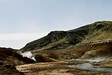
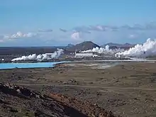 Reykjanesvirkjun geothermal power plant
%252C_Grindav%C3%ADk.JPG.webp)
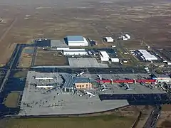 Keflavík International Airport
References
- "Reykjanes Peninsula". visitreykjanes.is. Retrieved December 1, 2019.
- "Information about Keflavík". guidetoiceland.is. Retrieved December 1, 2019.
- "Keflavik International Airport". isavia.is. Retrieved December 1, 2019.
- "Krysuvik geothermal area". icelandtravel.is. Retrieved December 1, 2019.
- "Svartsengi power plant". verkis.com. Retrieved December 1, 2019.
- "Bridge Between Continents". icelandtravel.is. Retrieved December 1, 2019.
- "Leifur Eriksson Air Terminal". lsretail.com. Retrieved December 1, 2019.
- Thor Thordarson, Armann Hoskuldsson: Iceland. Classic geology of Europe 3. Harpenden 2002, p.48-49, eg.
- Reykjanes. Catalogue of Icelandic Volcanoes. Retrieved 17 August 2020.
- Icelandic Met Office. Aviation colour code. Retrieved 17. August 2020.
- Jillian Mary Verbeurgt: A comparative analysis of the magnetic anomalies associated with the geothermal systems on Reykjanes peninsula. Master of Science (M.Sc.) in Sustainable Energy Science. Haraldur Auðunsson, Supervisor. Reykjavík University. September 2019 Retrieved 17. August 2020.
- Thor Thordarson, Armann Hoskuldsson: Iceland. Classic geology of Europe 3. Harpenden 2002, p.14 and 63.
- Helgi Páll Jónsson: Eldfjallagarður og jarðminjasvæði á Reykjanesskaga. Jarðvísindadeild Háskóli Íslands 2011. MS ritgerð. Leiðbeinendur Ólafur Ingólfsson. Skoðað 17. ágúst 2020.
- Brennisteinsfjöll. Detailed description. In: Catalogue of Icelandic Volcanoes.] Retrieved 17 August 2020
External links
 Southwest Iceland travel guide from Wikivoyage
- Reykjanes
- Photography