Stockton, Minnesota
Stockton is a city in Winona County, Minnesota, United States. The population was 697 at the 2010 census.[6]
Stockton | |
|---|---|
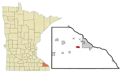 Location of Stockton, Minnesota | |
| Coordinates: 44°1′32″N 91°46′23″W | |
| Country | United States |
| State | Minnesota |
| County | Winona |
| Government | |
| • Type | Mayor - Council |
| • Mayor | Dave Johannes |
| Area | |
| • Total | 1.70 sq mi (4.40 km2) |
| • Land | 1.70 sq mi (4.40 km2) |
| • Water | 0.00 sq mi (0.00 km2) |
| Elevation | 751 ft (229 m) |
| Population | |
| • Total | 697 |
| • Estimate (2019)[3] | 737 |
| • Density | 433.78/sq mi (167.50/km2) |
| Time zone | UTC-6 (Central (CST)) |
| • Summer (DST) | UTC-5 (CDT) |
| ZIP code | 55988 |
| Area code(s) | 507 |
| FIPS code | 27-62896[4] |
| GNIS feature ID | 0652652[5] |
| Website | www |
History
Stockton was platted in 1856.[7] The city was named after J. B. Stockton, an early landowner.[8][9] A post office was established at Stockton in 1855, and remained in operation until 1959.[10] The city has one property listed on the National Register of Historic Places, the 1859 Trinity Episcopal Church.[11] The Winona and St. Peter Railroad was founded in 1861 in Winona, Minnesota. The first 11 miles from Winona to Stockton were completed by the end of 1862, making the it the second operational railroad in Minnesota, after the St Paul and Pacific Line from St. Paul to St. Anthony Falls.[12]
Geography
According to the United States Census Bureau, the city has a total area of 1.70 square miles (4.40 km2), all of it land.[13]
Demographics
| Historical population | |||
|---|---|---|---|
| Census | Pop. | %± | |
| 1880 | 214 | — | |
| 1950 | 235 | — | |
| 1960 | 242 | 3.0% | |
| 1970 | 346 | 43.0% | |
| 1980 | 517 | 49.4% | |
| 1990 | 529 | 2.3% | |
| 2000 | 682 | 28.9% | |
| 2010 | 697 | 2.2% | |
| 2019 (est.) | 737 | [3] | 5.7% |
| U.S. Decennial Census[14] | |||
2010 census
As of the census[2] of 2010, there were 697 people, 260 households, and 194 families living in the city. The population density was 410.0 inhabitants per square mile (158.3/km2). There were 282 housing units at an average density of 165.9 per square mile (64.1/km2). The racial makeup of the city was 95.8% White, 0.7% African American, 2.4% Asian, 0.4% from other races, and 0.6% from two or more races. Hispanic or Latino of any race were 1.7% of the population.
There were 260 households, of which 34.2% had children under the age of 18 living with them, 60.8% were married couples living together, 7.3% had a female householder with no husband present, 6.5% had a male householder with no wife present, and 25.4% were non-families. 18.5% of all households were made up of individuals, and 5% had someone living alone who was 65 years of age or older. The average household size was 2.68 and the average family size was 3.02.
The median age in the city was 35.9 years. 25.4% of residents were under the age of 18; 7.8% were between the ages of 18 and 24; 27.3% were from 25 to 44; 30.6% were from 45 to 64; and 9% were 65 years of age or older. The gender makeup of the city was 51.2% male and 48.8% female.
2000 census
As of the census[4] of 2000, there were 682 people, 236 households, and 184 families living in the city. The population density was 419.0 people per square mile (161.5/km2). There were 246 housing units at an average density of 151.1 per square mile (58.3/km2). The racial makeup of the city was 99.12% White, 0.44% Native American, 0.15% Asian, and 0.29% from two or more races. Hispanic or Latino of any race were 0.29% of the population.
There were 236 households, out of which 44.5% had children under the age of 18 living with them, 61.4% were married couples living together, 8.9% had a female householder with no husband present, and 22.0% were non-families. 17.4% of all households were made up of individuals, and 7.2% had someone living alone who was 65 years of age or older. The average household size was 2.89 and the average family size was 3.26.
In the city, the population was spread out, with 32.1% under the age of 18, 9.2% from 18 to 24, 32.3% from 25 to 44, 17.7% from 45 to 64, and 8.7% who were 65 years of age or older. The median age was 31 years. For every 100 females, there were 107.9 males. For every 100 females age 18 and over, there were 101.3 males.
The median income for a household in the city was $41,250, and the median income for a family was $47,159. Males had a median income of $30,000 versus $22,778 for females. The per capita income for the city was $17,038. About 1.7% of families and 4.1% of the population were below the poverty line, including 5.7% of those under age 18 and 1.6% of those age 65 or over.
References
- "2019 U.S. Gazetteer Files". United States Census Bureau. Retrieved July 26, 2020.
- "U.S. Census website". United States Census Bureau. Retrieved 2012-11-13.
- "Population and Housing Unit Estimates". United States Census Bureau. May 24, 2020. Retrieved May 27, 2020.
- "U.S. Census website". United States Census Bureau. Retrieved 2008-01-31.
- "US Board on Geographic Names". United States Geological Survey. 2007-10-25. Retrieved 2008-01-31.
- "2010 Census Redistricting Data (Public Law 94-171) Summary File". American FactFinder. United States Census Bureau. Retrieved 27 April 2011.
- Upham, Warren (1920). Minnesota Geographic Names: Their Origin and Historic Significance. Minnesota Historical Society. p. 584.
- "Where Did Minnesota Towns Get Names? Most Colorful in U.S." The Winona Republican-Herald. July 12, 1949. p. 15. Retrieved January 24, 2015 – via Newspapers.com.

- Chicago and North Western Railway Company (1908). A History of the Origin of the Place Names Connected with the Chicago & North Western and Chicago, St. Paul, Minneapolis & Omaha Railways. p. 127.
- "Winona County". Jim Forte Postal History. Retrieved 15 August 2015.
- "Minnesota National Register Properties Database". Minnesota Historical Society. 2009. Retrieved 2017-12-25.
- Daniel R. Pratt, Andrew J. Schmidt, Andrea C. Vermeer, and Betsy H. Bradley - Railroads in Minnesota, 1862-1956 MPS. United States Department of the Interior, National Park Service. Aug 2002, St. Paul, MN Section E. Statement of Historic Contexts - I. Railroad Development in Minnesota, 1862-1956
- "US Gazetteer files 2010". United States Census Bureau. Archived from the original on January 12, 2012. Retrieved 2012-11-13.
- "Census of Population and Housing". Census.gov. Retrieved June 4, 2015.
External links
Municipalities and communities of Winona County, Minnesota, United States | ||
|---|---|---|
| Cities |  Map of Minnesota highlighting Winona County | |
| Townships | ||
| CDP | ||
| Unincorporated communities | ||
| Ghost towns | ||
| Footnotes | ‡This populated place also has portions in an adjacent county or counties | |
| ||