Stonegate, Colorado
Stonegate is an unincorporated community and a census-designated place (CDP) located in and governed by Douglas County, Colorado, United States. The CDP is a part of the Denver–Aurora–Lakewood, CO Metropolitan Statistical Area. The population of the Stonegate CDP was 8,962 at the United States Census 2010.[4] The Stonegate Village Metropolitan District provides services to the community, which lies in ZIP Code 80134.[3]
Stonegate, Colorado | |
|---|---|
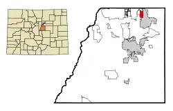 Location of the Stonegate CDP in Douglas County, Colorado. | |
 Stonegate Location of the Stonegate CDP in the United States. | |
| Coordinates: 39°32′08″N 104°48′12″W[1] | |
| Country | |
| State | |
| County | Douglas County |
| Government | |
| • Type | unincorporated community |
| Area | |
| • Total | 1.844 sq mi (4.777 km2) |
| • Land | 1.832 sq mi (4.745 km2) |
| • Water | 0.012 sq mi (0.032 km2) |
| Elevation | 5,896 ft (1,797 m) |
| Population (2010) | |
| • Total | 8,962 |
| • Density | 4,892/sq mi (1,889/km2) |
| Time zone | UTC-7 (MST) |
| • Summer (DST) | UTC-6 (MDT) |
| ZIP Code[3] | 80134 |
| Area codes | 303 & 720 |
| GNIS feature[2] | Stonegate CDP |
Geography
Stonegate is located in northeastern Douglas County. It is bordered to the east by the city of Parker and to the west by unincorporated Grand View Estates.
The E-470 toll road around the south side of the Denver metropolitan area forms the northern edge of Stonegate, with access from Exits 3 and 4. Downtown Denver is 21 miles (34 km) to the northwest.
The Stonegate CDP has an area of 1,180 acres (4.777 km2), including 7.9 acres (0.032 km2) of water.[1]
Demographics
The United States Census Bureau initially defined the Stonegate CDP for the United States Census 2000.
| Year | Pop. | ±% |
|---|---|---|
| 2000 | 6,284 | — |
| 2010 | 8,962 | +42.6% |
| 2020 | — | |
| Source: United States Census Bureau | ||
Education
The Douglas County School District serves Stonegate.
See also
- Outline of Colorado
- State of Colorado
- Colorado cities and towns
- Colorado counties
- Colorado metropolitan areas
References
- "State of Colorado Census Designated Places - BAS20 - Data as of January 1, 2020". United States Census Bureau. Retrieved December 21, 2020.
- "U.S. Board on Geographic Names: Domestic Names". United States Geological Survey. Retrieved December 21, 2020.
- "Zip Code 80134 Map and Profile". zipdatamaps.com. 2020. Retrieved December 21, 2020.
- "2010: DEC Summary File 1". United States Census Bureau. Retrieved December 21, 2020.
External links
Municipalities and communities of Douglas County, Colorado, United States | ||
|---|---|---|
| Cities |  Map of Colorado highlighting Douglas County | |
| Towns | ||
| CDPs | ||
| Unincorporated communities | ||
| Footnotes | ‡This populated place also has portions in an adjacent county or counties | |
| ||