Westcreek, Colorado
Westcreek is an unincorporated community and a census-designated place (CDP) located in and governed by Douglas County, Colorado, United States. The CDP is a part of the Denver–Aurora–Lakewood, CO Metropolitan Statistical Area. The population of the Westcreek CDP was 129 at the United States Census 2010.[4] The Sedalia post office (Zip Code 80135) serves the area.[3]
Westcreek, Colorado | |
|---|---|
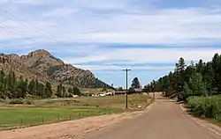 Westcreek Road in Westcreek. | |
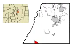 Location of the Westcreek CDP in Douglas County, Colorado. | |
 Westcreek Location of the Westcreek CDP in the United States. | |
| Coordinates: 39°08′59″N 105°09′45″W[1] | |
| Country | |
| State | |
| County | Douglas County |
| Government | |
| • Type | unincorporated community |
| Area | |
| • Total | 1.260 sq mi (3.263 km2) |
| • Land | 1.218 sq mi (3.155 km2) |
| • Water | 0.042 sq mi (0.108 km2) |
| Elevation | 7,493 ft (2,284 m) |
| Population (2010) | |
| • Total | 129 |
| • Density | 106/sq mi (41/km2) |
| Time zone | UTC-7 (MST) |
| • Summer (DST) | UTC-6 (MDT) |
| ZIP Code[3] | Sedalia 80135 |
| Area codes | 303 & 720 |
| GNIS feature[2] | Westcreek CDP |
Geography
Westcreek is located in southwestern Douglas County. It is in the valley of West Creek, a north-flowing tributary of Horse Creek and part of the South Platte River watershed.
Colorado State Highway 67 passes through the community, leading north down the West Creek/Horse Creek valley 9 miles (14 km) to Deckers and southeast 15 miles (24 km) to Woodland Park.
The Westcreek CDP has an area of 806 acres (3.263 km2), including 27 acres (0.108 km2) of water.[1]
Demographics
The United States Census Bureau initially defined the Westcreek CDP for the United States Census 2000.
| Year | Pop. | ±% |
|---|---|---|
| 2000 | 105 | — |
| 2010 | 129 | +22.9% |
| 2020 | — | |
| Source: United States Census Bureau | ||
Education
The Douglas County School District serves Westcreek.
See also
- Outline of Colorado
- State of Colorado
- Colorado cities and towns
- Colorado counties
- Colorado metropolitan areas
References
- "State of Colorado Census Designated Places - BAS20 - Data as of January 1, 2020". United States Census Bureau. Retrieved December 21, 2020.
- "U.S. Board on Geographic Names: Domestic Names". United States Geological Survey. Retrieved December 15, 2020.
- "Zip Code 80135 Map and Profile". zipdatamaps.com. 2020. Retrieved December 21, 2020.
- "2010: DEC Summary File 1". United States Census Bureau. Retrieved December 21, 2020.
External links
Municipalities and communities of Douglas County, Colorado, United States | ||
|---|---|---|
| Cities |  Map of Colorado highlighting Douglas County | |
| Towns | ||
| CDPs | ||
| Unincorporated communities | ||
| Footnotes | ‡This populated place also has portions in an adjacent county or counties | |
| ||