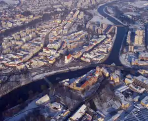
Strakonice
Strakonice (Czech pronunciation: [ˈstrakoɲɪtsɛ]; German: Strakonitz) is a town in the South Bohemian Region of the Czech Republic.
Strakonice | |
|---|---|
Town | |
 Aerial view | |
 Flag  Coat of arms | |
 Strakonice Location in the Czech Republic | |
| Coordinates: 49°15′41″N 13°54′9″E | |
| Country | |
| Region | South Bohemian |
| District | Strakonice |
| First mentioned | 1367 |
| Government | |
| • Mayor | Břetislav Hrdlička |
| Area | |
| • Total | 34.68 km2 (13.39 sq mi) |
| Elevation | 393 m (1,289 ft) |
| Population (2020-01-01[1]) | |
| • Total | 22,646 |
| • Density | 650/km2 (1,700/sq mi) |
| Time zone | UTC+1 (CET) |
| • Summer (DST) | UTC+2 (CEST) |
| Postal code | 386 01 |
| Website | www.strakonice.eu |
Geography
The town is located at the confluence of the Volyňka and Otava rivers. The municipal area comprises the districts of Dražejov, Hájská, Modlešovice, Přední Ptákovice, Strakonice proper (I and II), Střela, and Virt. The population is around 23,000.
Close to the town is the natural monument Bažantnice u Pracejovic.
History

The settlement of this region took place in the second half of 12th century. A moated castle on the Otava River was built by the noble House of Strakonice at the beginning of the 13th century. In 1243 they donated a part of the castle to the knights hospitaller of the Order of Saint John. In 1367 Strakonice obtained city rights.
From the beginning of the 15th century the Knights Hospitaller owned the whole castle as well as the surrounding manor. In 1420 the Hussite commander Jan Žižka occupied Strakonice, but failed to capture the fortress. Strakonice Castle experienced an extensive reconstruction to a representation residence of the Grand Priors of the Order in the 16th century, the later modifications were minor only.
Nowadays a part of the castle serves as a museum of the region of Strakonice.
Climate
Strakonice has a cool, wet, and temperate inland version of a humid continental climate (Dfb).
| Climate data for Strakonice | |||||||||||||
|---|---|---|---|---|---|---|---|---|---|---|---|---|---|
| Month | Jan | Feb | Mar | Apr | May | Jun | Jul | Aug | Sep | Oct | Nov | Dec | Year |
| Average high °C (°F) | 0.8 (33.4) |
2.5 (36.5) |
8.3 (46.9) |
13.5 (56.3) |
18.7 (65.7) |
21.8 (71.2) |
23.6 (74.5) |
23.0 (73.4) |
19.2 (66.6) |
13.0 (55.4) |
6.0 (42.8) |
2.4 (36.3) |
12.7 (54.9) |
| Daily mean °C (°F) | −2.3 (27.9) |
−1.2 (29.8) |
3.5 (38.3) |
7.9 (46.2) |
12.8 (55.0) |
16.0 (60.8) |
17.8 (64.0) |
17.2 (63.0) |
13.7 (56.7) |
8.3 (46.9) |
3.0 (37.4) |
−0.3 (31.5) |
8.0 (46.4) |
| Average low °C (°F) | −5.4 (22.3) |
−4.9 (23.2) |
−1.2 (29.8) |
2.4 (36.3) |
6.9 (44.4) |
10.3 (50.5) |
12.0 (53.6) |
11.5 (52.7) |
8.2 (46.8) |
3.7 (38.7) |
0.0 (32.0) |
−3.0 (26.6) |
3.4 (38.1) |
| Average precipitation mm (inches) | 48 (1.9) |
40 (1.6) |
45 (1.8) |
46 (1.8) |
75 (3.0) |
83 (3.3) |
92 (3.6) |
81 (3.2) |
58 (2.3) |
45 (1.8) |
45 (1.8) |
54 (2.1) |
712 (28.0) |
| Source: Climate-Data.ORG | |||||||||||||
Economy


Since the 19th century Strakonice was a main production site for fez hats and it also became an industrial center known for its motorbikes and hand guns.
Strakonice is also well known for a brewery called: DUDÁK – Měšťanský pivovar Strakonice, a.s., located nearby the castle. The Strakonice Burghers' Brewery is the last brewery in the Czech Republic to still be owned by a town. The tradition of beer brewing has been linked to the rich history of the Otava River region since 1649.
Notable people
- Jan Antonín Losy, (c. 1650–1721), lute player and composer
- František Čelakovský (1799–1852), writer and translator
- Leopold Ehrmann (1886–1951), architect
- Xena Longenová (1891–1928), actress
- Zdeněk Troška (born 1953), film director
Twin towns – sister cities
Strakonice is twinned with:[2][3]
 Bad Salzungen, Germany
 Calderdale, England, United Kingdom
 Lengnau, Switzerland
 Rawicz, Poland
References
- "Population of Municipalities – 1 January 2020". Czech Statistical Office. 2020-04-30.
- "Partnerská města" (in Czech). Město Strakonice. Retrieved 2019-09-23.
- "Rawicka delegacja na Białorusi" (in Polish). Gmina Rawicz. 2019-01-30. Retrieved 2019-09-23.