Tai'an
Tai'an (Chinese: 泰安; pinyin: Tài'ān) is a prefecture-level city in Western Shandong Province of the People's Republic of China. Centered on Mount Tai, the city borders the provincial capital of Jinan to the north, Zibo to the east, Linyi to the southeast, Liaocheng to the extreme west and Jining to the south. To the west, Tai'an is separated from the province of Henan by the Yellow River.
Tai'an
泰安市 | |
|---|---|
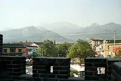 Mount Tai seen across Tai'an | |
 Location of Tai'an City jurisdiction in Shandong | |
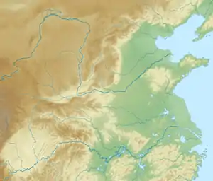 Tai'an Location on the North China Plain  Tai'an Tai'an (China) | |
| Coordinates (Tai'an municipal government): 36°12′07″N 117°05′13″E | |
| Country | People's Republic of China |
| Province | Shandong |
| County-level divisions | 6 |
| Municipal seat | Taishan District |
| Government | |
| • CPC Secretary | Cui Honggang[1] |
| • Mayor | Li Xixin |
| Area | |
| • Prefecture-level city | 7,762 km2 (2,997 sq mi) |
| • Urban | 2,086.8 km2 (805.7 sq mi) |
| • Metro | 2,086.8 km2 (805.7 sq mi) |
| Elevation | 167 m (548 ft) |
| Highest elevation | 1,645 m (5,397 ft) |
| Population (2019 census)[3] | |
| • Prefecture-level city | 5,635,000 |
| • Density | 730/km2 (1,900/sq mi) |
| • Urban | 1,735,425 |
| • Urban density | 830/km2 (2,200/sq mi) |
| • Metro | 1,735,425 |
| • Metro density | 830/km2 (2,200/sq mi) |
| Time zone | UTC+8 (China Standard) |
| Area code(s) | 538 |
| ISO 3166 code | CN-SD-09 |
| License Plate Prefix | 鲁J |
| Website | www |
Its population was 5,494,207 as of the 2010 census, of whom 1,735,425 lived in the built-up (or metro) area made of two urban districts (Taishan District and Daiyue District).
Administration
The prefecture-level city of Tai'an administers six county-level divisions, including two districts, two county-level cities and two counties.
- Taishan District (泰山区)
- Daiyue District (岱岳区)
- Xintai City (新泰市)
- Feicheng City (肥城市)
- Ningyang County (宁阳县)
- Dongping County (东平县)
| Map |
|---|

History
Etymology
Tai'an is named after Mount Tai. In Chinese, Tai (泰) means "significant". Thus, the name Tai'an is derived from the ancient saying: "If Mount Tai is safe, then the four seas (the world) are safe (安; ān). "
Early history
Tai'an was home to the Dawenkou culture during the neolithic era. During the Spring and Autumn period and the Warring States period, the region belonged to the states of Qi and Lu. The site of major historical and cultural significance in the area is Mount Tai. It attracted multiple emperors throughout the dynasties to visit, offer sacrifice to the heaven gods and pray for harvest. Confucius, Sima Qian, Cao Zhi, Li Bai and other litterateurs visited here and many great works were produced.
Modern history
In 1909, German colonials built Tai'an-Fu Railway Station along with the construction of Tianjin–Pukou railway (Tientsin–Pukow railway). On 10 November of the following year, the first train service passed through the station.[4]
On 1 May 1928, Chiang Kai-shek, the leader of KMT and nationalist revolutionary army, commanded the attack of Tai'an and occupied it the next day.[5]
In October 1937, exiled students from Peking, Tianjin and other major cities arrived in Tai'an seeking asylum after the north of Yellow river was occupied by the Japanese forces. On 24 December 1937, Japanese troops crossed the Yellow River, occupied Jinan on the next day, and bombed Tai'an. On the night of 31 December, the Japanese occupied Tai'an.[6] Local resistants were assembled autonomously to fight against the occupation.[7]
Geography and climate
Tai'an is centered on the south side of Mount Tai.Dongping Lake is the biggest lake.
Tai'an lies in the northern temperate zone and has a continental, semi-humid monsoon climate. The average annual temperatures are −2.1 °C (28.2 °F) (January), 12.8 °C (55.0 °F) (annual average), and 26.0 °C (78.8 °F) (July). The average annual precipitation is 681 mm (26.8 in).
| Climate data for Tai'an (normals 1981–2010, extremes 1951–2000) | |||||||||||||
|---|---|---|---|---|---|---|---|---|---|---|---|---|---|
| Month | Jan | Feb | Mar | Apr | May | Jun | Jul | Aug | Sep | Oct | Nov | Dec | Year |
| Record high °C (°F) | 15.8 (60.4) |
21.8 (71.2) |
26.1 (79.0) |
33.8 (92.8) |
38.6 (101.5) |
40.7 (105.3) |
39.6 (103.3) |
40.0 (104.0) |
34.6 (94.3) |
31.6 (88.9) |
27.1 (80.8) |
17.4 (63.3) |
40.7 (105.3) |
| Average high °C (°F) | 4.3 (39.7) |
7.6 (45.7) |
13.4 (56.1) |
20.7 (69.3) |
26.1 (79.0) |
30.8 (87.4) |
31.0 (87.8) |
30.1 (86.2) |
26.6 (79.9) |
20.8 (69.4) |
12.9 (55.2) |
6.0 (42.8) |
19.2 (66.5) |
| Daily mean °C (°F) | −1.7 (28.9) |
1.4 (34.5) |
7.2 (45.0) |
14.4 (57.9) |
19.9 (67.8) |
24.8 (76.6) |
26.3 (79.3) |
25.2 (77.4) |
20.6 (69.1) |
14.3 (57.7) |
6.6 (43.9) |
0.2 (32.4) |
13.3 (55.9) |
| Average low °C (°F) | −6.4 (20.5) |
−3.6 (25.5) |
1.7 (35.1) |
8.3 (46.9) |
13.7 (56.7) |
19.0 (66.2) |
22.2 (72.0) |
21.0 (69.8) |
15.4 (59.7) |
8.9 (48.0) |
1.4 (34.5) |
−4.4 (24.1) |
8.1 (46.6) |
| Record low °C (°F) | −22.4 (−8.3) |
−19.3 (−2.7) |
−12.6 (9.3) |
−5.7 (21.7) |
0.7 (33.3) |
8.2 (46.8) |
13.1 (55.6) |
10.4 (50.7) |
1.8 (35.2) |
−3.3 (26.1) |
−12.6 (9.3) |
−20.3 (−4.5) |
−22.4 (−8.3) |
| Average precipitation mm (inches) | 5.3 (0.21) |
9.3 (0.37) |
17.4 (0.69) |
27.5 (1.08) |
54.6 (2.15) |
87.7 (3.45) |
205.9 (8.11) |
156.0 (6.14) |
65.5 (2.58) |
32.7 (1.29) |
16.7 (0.66) |
7.0 (0.28) |
685.6 (27.01) |
| Average precipitation days (≥ 0.1 mm) | 2.4 | 3.2 | 4.7 | 5.4 | 6.5 | 8.6 | 13.6 | 10.5 | 7.1 | 5.0 | 3.5 | 3.1 | 73.6 |
| Average relative humidity (%) | 59 | 56 | 55 | 58 | 65 | 64 | 80 | 81 | 74 | 69 | 66 | 63 | 66 |
| Source 1: China Meteorological Administration[8][9] | |||||||||||||
| Source 2: Weather China (precipitation days 1971–2000)[10] | |||||||||||||
Education
- Shandong University of Science and Technology
- Shandong First Medical University
- Shandong Agricultural University
- Taishan University
- Tai'an Public Health School
- Tai'an Polytechnic College
- Shandong Foreign Trade Vocational College Taian Campus
Secondary schools
- Tai’an the first high school (泰安一中)
Transportation
Tai'an (Taishan Station) is located on the Beijing–Shanghai railway Line, which connects Beijing to Shanghai, as well as on the G2 Beijing–Shanghai Expressway and on the Tai-Lai Expressway (west-east from Tai'an to Laiwu). There is a four-lane highway from Tai'an to the Jinan Airport. Within Tai'an there are large tree lined avenues throughout the city. The nearest major airport is Jinan Yaoqiang International Airport, about 120 km (75 mi) to the north.
References
- 全市领导干部会议召开 崔洪刚任中共泰安市委书记 (in Chinese). dzwww.com. 9 May 2018. Retrieved 1 May 2020.
- 最新人口信息 www.hongheiku.com (in Chinese). hongheiku. Retrieved 12 January 2021.
- 最新人口信息 www.hongheiku.com (in Chinese). hongheiku. Retrieved 12 January 2021.
- Daily Consular and Trade Reports, Issues 152-228, Department of Commerce and Labor, Bureau of Manufactures, 1913
- https://wx.abbao.cn/a/725-f2fa94a79bc7338b.html
- https://shandong-chorography.org/database/c91/section/5/article/31/
- https://shandong-chorography.org/database/c91/section/5/article/35/
- 中国气象数据网 - WeatherBk Data (in Chinese). China Meteorological Administration. Retrieved 14 April 2020.
- 中国气象局 国家气象信息中心 (in Chinese). China Meteorological Administration. Archived from the original on 18 March 2013. Retrieved 12 December 2012.
- 泰安 - 气象数据 -中国天气网 (in Chinese). Weather China.
External links
 Tai'an travel guide from Wikivoyage
- Government website of Tai'an (in Simplified Chinese)
Major cities along the Yellow River | ||
|---|---|---|
| Province-level subdivisions | Cities (from upper reaches to lower reaches) |  |
| Gansu | ||
| Ningxia | ||
| Inner Mongolia | ||
| Shanxi | ||
| Shaanxi | ||
| Henan | ||
| Shandong | ||
Major cities along the Pearl River · Major cities along the Yangtze River | ||
| Authority control |
|---|