Thiès Region
Thiès is a region of western Senegal. The capital is also called Thiès.
Thiès Region
Région de Thiès | |
|---|---|
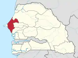 Location of Thiès in Senegal | |
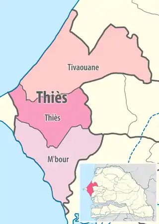 Thiès région, divided into 3 départements | |
| Coordinates: 14°46′N 16°54′W | |
| Country | Senegal |
| Capital | Thiès |
| Départements | |
| Government | |
| • Governor | Amadou Sy |
| Area | |
| • Total | 6,670 km2 (2,580 sq mi) |
| Population (2013 census) | |
| • Total | 1,709,112 |
| • Density | 260/km2 (660/sq mi) |
| Time zone | UTC+0 (GMT) |
| HDI (2017) | 0.556[1] medium · 3rd |
Geography
It has two coastlines, one in the north with the Grande Côte housing the Niayes vegetable market, one to the south with the Petite Côte, one of the tourist areas of Senegal.
Principally the main passageway between the peninsula and the rest of the country, the region of Thies has received a communication route connected to the first rail line and new road infrastructure.
Relatively small, yet it is the most populous region after the Dakar, with a population of 1,709,112 inhabitants at the end 2007.[2]
The coastal communities dependent on fishing, growing crops and coastal tourism for subsistence. The interior of the region was the peanut basin. Phosphates are also mined there.
History
The Thiès Region has always been occupied by the Serer people since the ancient Serers and their ancestors. However, in the pre-colonial period, more so around the 16th century, the Wolof immigrants among others have settled in.[3][4][5] Like the Fatick Region, the entire Thiès Region is strongly Serer and one of the most important of Serer country.[3][4][5][6] It is also where many of the Serer sacred and historical sites are found. The area is well represented by the Cangin, a sub-group of the Serers, who had a fierce reputation for protecting their country from outsiders in precolonial times as well as during the colonial-era (see Timeline of Serer history and Serer medieval history).
Geographically, the region partially overlaps with the precolonial Kingdoms of Cayor and Baol.[7] The Kingdom of Baol was ruled by the Joof family for several centuries until c 1549. During the colonial-era, its development was supported by the railway line - the Dakar-Saint-Louis railway in the late nineteenth century, and then with the Dakar-Niger railway. Thus Administratively, it is one of the oldest in the country.
Administrative divisions
Thiès region is divided into 3 departments (départements), 14 communes (soon 15 communes in 2023), 12 arrondissements, 32 communautés rurales and 3 communes d'arrondissement.
Departments
The region is divided[8] into 3 departments as follows':
Communes
- Ville d'Akon (planned)
- M'bour
- Joal-Fadiouth
- Nguekokh
- Ngaparou
- Popenguine-Ndayane
- Saly
- Somone
- Thiadiaye
Arrondissements
- Thiès Nord (also commune d'arrondissement)
- Thiès Sud (divided into 2 communes d'arrondissement)
- Keur Moussa
- Notto
- Thiénaba
Communautés rurales
.jpg.webp)
- Diender Geudj
- Fandène
- Keur Moussa
- Notto
- Tassette
- Ndiayène Sirah
- Thiénaba
- Ngoudiane
- Touba Toul
- Méouane
- Taïba Ndiaye
- Darou-Khoudoss
- Koul
- Mérina Dakhar
- Pékesse
- Nbayène
- Ngandiouf
- Niakhène
- Thilmakha
- Chérif Lo
- Mont Rolland
- Notto Gouye Diama
- Pambal
- Pire Gourèye
In 2003, the rural population was 769,884,[9] grouped in 31 villages, in communautés rurales.
References
- "Sub-national HDI - Area Database - Global Data Lab". hdi.globaldatalab.org. Retrieved 13 September 2018.
- Senegal at Geohive Archived 19 April 2015 at the Wayback Machine
- Klein, Martin A., "Islam and Imperialism in Senegal Sine-Saloum, 1847–1914", p. 7, Edinburgh University Press (1968), ISBN 0-85224-029-5
- Diange, Pathé. "Les Royaumes Sérères", Présence Africaine. No.54 (1965) p-p 142-72
- Ba, Abdou Bouri, "Essai sur l’histoire du Saloum et du Rip", Avant-propos par Charles Becker et Victor Martin. Publié dans le Bulletin de l’Institut Fondamental d'Afrique Noire (IFAN), pp 10-13
- Encyclopædia Britannica, inc, "The New Encyclopædia Britannica, Volume 29", ed : 13, Encyclopædia Britannica, 2003, p 855-6, ISBN 0-85229-961-3
- (in French) Djibril Diop, "Décentralisation et gouvernance locale au Sénégal". Quelle pertinence pour le développement local ?, Paris, L'Harmattan, 2006, p. 69 ISBN 2-296-00862-3
- (in French) Decree n°2002-166 of 21 February 2002 fixant le ressort territorial et le chef lieu des régions et des départements
- (in French) Source : PEPAM