Tigris–Euphrates river system
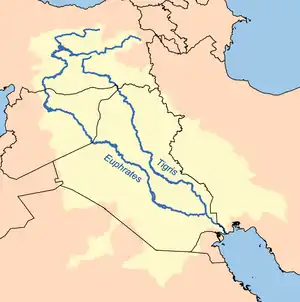
The Tigris–Euphrates river system is a large river system in Western Asia which discharges into the Persian Gulf. Its principal rivers are the Tigris and Euphrates along with smaller tributaries.
| Tigris–Euphrates river system | |
|---|---|
 | |
| Ecology | |
| Realm | Palearctic |
| Biome | temperate floodplain rivers and wetlands |
| Geography | |
| Area | 879,790 km2 (339,690 sq mi) |
| Countries | |
| Oceans or seas | empties into the Persian Gulf |
| Rivers | Tigris, Euphrates, Greater Zab, Lesser Zab. |
From their sources and upper courses in the mountains of eastern Turkey, the rivers descend through valleys and gorges to the uplands of Syria and northern Iraq and then to the alluvial plain of central Iraq. Other tributaries join the Tigris from sources in the Zagros Mountains to the east. The rivers flow in a south-easterly direction through the central plain and combine at Al-Qurnah to form the Shatt al-Arab and discharge into the Persian Gulf.[1] The rivers and their tributaries drain an area of 879,790 km²,[2] including portions of Turkey, Syria, Iraq, Iran, Saudi Arabia, and Kuwait.[3][4][5][6]
The region has historical importance as part of the Fertile Crescent region, in which civilization is believed to have first emerged.
Geography
The ecoregion is characterized by two large rivers, the Tigris and Euphrates. The high mountains in the upper watershed receive more rain and snow than the lower watershed, which has a hot and arid subtropical climate. Annual snow melt from the mountains brings spring floods, and sustains permanent and seasonal marshes in the lowlands.
The plain between the two rivers is known as Mesopotamia. As part of the larger Fertile Crescent, it saw the earliest emergence of literate urban civilization in the Uruk period, for which reason it is often described as a "Cradle of Civilization".
There is a large floodplain in the lower basin where the Euphrates, Tigris, and Karun rivers converge to create the Mesopotamian Marshes, which includes permanent lakes, marshes, and riparian forest. The hydrology of these vast marshes is extremely important to the ecology of the entire upper Persian Gulf.
The Tigris–Euphrates Basin is shared by Turkey, Syria, Iraq, Iran, Saudi Arabia, and Kuwait.[6] Many Tigris tributaries originate in Iran and a Tigris–Euphrates confluence forms part of the Kuwait–Iraq border.[7] Since the 1960s and in the 1970s, when Turkey began the GAP project in earnest, water disputes have regularly occurred in addition to the associated dam's effects on the environment. In addition, Syrian and Iranian dam construction has also contributed to political tension within the basin, particularly during drought.
Ecology
The most abundant fishes are species of barbs (Barbus), some of which can reach up to two meters in length. Some species have been important food sources for residents for thousands of years. Many species move seasonally between the river and the marshes for spawning, feeding, and overwintering. The Hilsa shad (Tenualosa ilisha) is an important food fish which lives in the coastal waters and spawns in the lower reaches of the basin. Other ocean species occasionally visit the lower reaches of the rivers; bull sharks (Carcharhinus leucas) used to swim up the Tigris as far as Baghdad.[8]
Endemic fish species in the lower basin include Glyptothorax steindachneri and Hemigrammocapoeta elegans, and as well as two cave fishes, Caecocypris basimi and the Iraq blind barb (Typhlogarra widdowsoni), from a cave habitat near Haditha on the Euphrates.[8] One-third of the fish species in the upper watersheds are endemic, including species of Aphanius, Glyptothorax, Cobitis, Orthrias, and Schistura. Two blind fish species, the Iran cave barb (Iranocypris typhlops) and the Zagros blind loach (Eidinemacheilus smithi), are endemic to cave systems in Iran's upper Karun River watershed.[9]
Mesopotamian Marshes
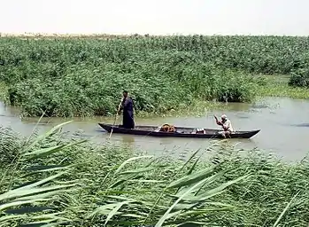
The Mesopotamian Marshes in southern Iraq were historically the largest wetland ecosystem of Western Eurasia. The aquatic vegetation includes reeds, rushes, and papyrus, which support numerous species. Areas around the Tigris and the Euphrates are very fertile. Marshy land is home to water birds, some stopping here while migrating, and some spending the winter in these marshes living off the lizards, snakes, frogs, and fish. Other animals found in these marshes are water buffalo, two endemic rodent species, antelopes and gazelles and small animals such as the jerboa and several other mammals. The wetland birds Basra reed warbler (Acrocephalus griseldis) and Iraq babbler (Turdoides altirostris) are endemic to the Mesopotamian Marshes. The Basra reed warbler is endangered. Another wetland endemic species, Bunn's short-tailed bandicoot rat (Nesokia bunnii), is possibly extinct.
Their drainage began in the 1950s, to reclaim land for agriculture and oil exploration. Saddam Hussein extended this work in the late 1980s and early 1990s, as part of ecological warfare against the Marsh Arabs, a rebellious group of people in Baathist Iraq. However, with the breaching of the dikes by local communities after the 2003 invasion of Iraq and the ending of a four-year drought that same year, the process has been reversed and the marshes have experienced a substantial rate of recovery. The permanent wetlands now cover more than 50% of pre-1970s levels, with a remarkable regrowth of the Hammar and Hawizeh Marshes and some recovery of the Central Marshes.[10]
Ecological threats
Iraq suffers from desertification and soil salination due in large part to thousands of years of agricultural activity. Water and plant life are sparse. Saddam Hussein's government water-control projects drained the inhabited marsh areas east of An Nasiriyah by drying up or diverting streams and rivers. Shi'a Muslims were displaced under the Ba'athist regime. The destruction of the natural habitat poses serious threats to the area's wildlife populations. There are also inadequate supplies of potable water.
The marshlands were an extensive natural wetlands ecosystem which developed over thousands of years in the Tigris–Euphrates basin and once covered 15–20,000 square kilometers. In the 1980s, this ecoregion was put in grave danger during the Iran–Iraq War. The Mesopotamian Marshes, which were inhabited by the Marsh Arabs, were almost completely drained. Although they had started to recover after the fall of Ba'athist Iraq in 2003, drought, intensive dam construction and irrigation schemes upstream have caused them to dry up once more.[11]According to the United Nations Environmental Program and the AMAR Charitable Foundation, between 84% and 90% of the marshes have been destroyed since the 1970s. In 1994, 60 percent of the wetlands were destroyed by Hussein's regime – drained to permit military access and greater political control of the native Marsh Arabs. Canals, dykes and dams were built routing the water of the Tigris and Euphrates Rivers around the marshes, instead of allowing water to move slowly through the marshland. After part of the Euphrates was dried up due to re-routing its water to the sea, a dam was built so water could not back up from the Tigris and sustain the former marshland. Some marshlands were burned and pipes buried underground helped to carry away water for quicker drying.
The drying of the marshes led to the disappearance of the salt-tolerant vegetation; the plankton rich waters that fertilized surrounding soils; 52 native fish species; the wild boar, red fox, buffalo and water birds of the marsh habitat.
Water dispute
The issue of water rights became a point of contention for Iraq, Turkey and Syria beginning in the 1960s when Turkey implemented a public-works project (the GAP project) aimed at harvesting the water from the Tigris and Euphrates rivers through the construction of 22 dams, for irrigation and hydroelectric energy purposes. Although the water dispute between Turkey and Syria was more problematic, the GAP project was also perceived as a threat by Iraq. The tension between Turkey and Iraq about the issue was increased by the effect of Syria and Turkey's participation in the UN embargo against Iraq following the Gulf War. However, the issue had never become as significant as the water dispute between Turkey and Syria.[12]
The 2008 drought in Iraq sparked new negotiations between Iraq and Turkey over trans-boundary river flows. Although the drought affected Turkey, Syria and Iran as well, Iraq complained regularly about reduced water flows. Iraq particularly complained about the Euphrates River because of the large amount of dams on the river. Turkey agreed to increase the flow several times, beyond its means in order to supply Iraq with extra water. Iraq has seen significant declines in water storage and crop yields because of the drought. To make matters worse, Iraq's water infrastructure has suffered from years of conflict and neglect.[13]
In 2008, Turkey, Iraq and Syria agreed to restart the Joint Trilateral Committee on water for the three nations for better water resources management. Turkey, Iraq and Syria signed a memorandum of understanding on September 3, 2009, in order to strengthen communication within the Tigris–Euphrates Basin and to develop joint water-flow-monitoring stations. On September 19, 2009, Turkey formally agreed to increase the flow of the Euphrates River to 450 to 500 m³/s, but only until October 20, 2009. In exchange, Iraq agreed to trade petroleum with Turkey and help curb Kurdish militant activity in their border region. One of Turkey's last large GAP dams on the Tigris – the Ilisu Dam – is strongly opposed by Iraq and is the source of political strife.[14]
In media
- Dawn of the World, film, 2008.
- Zaman, The Man From The Reeds, film, 2003
References
- "Euphrates River". Encyclopædia Britannica. 17 December 2017. Retrieved 17 December 2017.
- "Euphrates–Tigris River Basin". AQUASTAT Survey 2008, UN Food and Agriculture Organization. Accessed 30 June 2020.
- Matthew Zentner (2012). Design and impact of water treaties: Managing climate change. p. 144. ISBN 9783642237430.
The Tigris-Euphrates-Shatt al Arab is shared between Iraq, Iran, Syria, Kuwait and Turkey.
- "Lower Tigris & Euphrates". feow.org. 2013.
- "Mesopotamia (2/3/2003)".
- Deniz Bozkurt; Omer Lutfi Sen (2012). "Hydrological response of past and future climate changes in the Euphrates-Tigris Basin" (PDF). p. 1.
The Euphrates-Tigris Basin, covering areas in five countries (Turkey, Iraq, Syria, Iran and Kuwait), is a major water resource of the Middle East.
- Dan Caldwel (2011). Vortex of Conflict: U.S. Policy Toward Afghanistan, Pakistan, and Iraq. p. 60. ISBN 9780804777490.
- "Lower Tigris & Euphrates". Freshwater Ecoregions of the World. Accessed 30 June 2020.
- "Upper Tigris & Euphrates". Freshwater Ecoregions of the World. Accessed 30 June 2020.
- Iraqi Marshlands: Steady Progress to Recovery Archived 2011-06-08 at the Wayback Machine (UNEP)
- http://news.bbc.co.uk/2/hi/middle_east/7906512.stm
- Uzgel I., 1992. GÜVENSİZLİK ÜÇGENİ: TÜRKİYE, SURİYE, IRAK VE SU SORUNU, MÜLKİYELİLER BİRLİĞİ DERGİSİ, 162, p.47-52
- https://www.reuters.com/article/environmentNews/idUSTRE54M0XG20090523 Turkey lets more water out of dams to Iraq: MP
- https://web.archive.org/web/20101231233038/http://www.google.com/hostednews/afp/article/ALeqM5giDgd3ukLR8UcfziUQcNToKyM_tw Turkey to up Euphrates flow to Iraq
External links
| Wikiquote has quotations related to: Tigris–Euphrates river system |
| Wikivoyage has a travel guide for Mesopotamia (Middle East). |
| Geography |
|  | ||||
|---|---|---|---|---|---|---|
| History |
| |||||
| Languages | ||||||
| Culture / Society |
| |||||
| Archaeology | ||||||