Tippecanoe River
The Tippecanoe River (/ˌtɪpikəˈnuː/ TIP-ee-kə-NOO) is a gentle, 182-mile-long (293 km)[1] river in the Central Corn Belt Plains ecoregion in northern Indiana. It flows from Big Lake in Noble County to the Wabash River near what is now Battle Ground, about 12 miles (19 km) northeast of Lafayette. The name "Tippecanoe" was derived from a Miami-Illinois word for buffalo fish, reconstructed as */kiteepihkwana/[2] or as kiteepihkwana siipiiwi.[3]
| Tippecanoe River | |
|---|---|
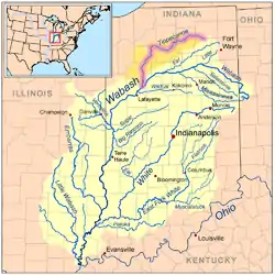 Map of the Wabash River watershed with the Tippecanoe River highlighted. | |
| Location | |
| Country | US |
| Physical characteristics | |
| Source | |
| • location | Big Lake in Noble County, Indiana |
| Mouth | |
• location | Wabash River near Battle Ground, Indiana |
| Length | 182 miles (293 km) |
| Basin size | 1,875 sq mi (4,860 km2) |
| Discharge | |
| • average | 5,110 cu ft/s (145 m3/s) |
The Tippecanoe River is fed by 88 natural lakes and has a drainage area of 1,250,000 acres (5,100 km2), spanning 14 counties. It supports more numerous imperiled species and overall species diversity than most streams of the upper Midwest.[4] The Nature Conservancy has identified it as one of the top ten rivers in the United States to preserve due to its ecological diversity and the high proportion of endangered species found in it.[4]
Course
The Tippecanoe River originates from multiple kettle lakes formed by ancient glaciers in what is now Noble County, Indiana. Numerous dams were built along its length, to create lakes and ponds for water power. The river flows west into Wilmot Pond, which is formed by a small dam on its western side. After Wilmot, it crosses into Kosciusko County and enters Backwaters Lake, the basin of Webster Lake. After going over the dam at Webster Lake, the river travels a few miles and enters Tippecanoe Lake. From there the river flows south and west through the southeast corner of Marshall County, then bends northwest through the northern part of Fulton County and through Pulaski County, from the northeast corner to the south central portion, traversing Tippecanoe River State Park along the way. It enters White County, where dams form Lake Freeman and Lake Shafer. The river exits Lake Freeman from the south and flows through the west part of Carroll County into Tippecanoe County, where it joins the Wabash River.
In addition to Tippecanoe County, five townships through which the river flows are named Tippecanoe:
History
The Battle of Tippecanoe, in which Governor William Henry Harrison defeated the Indian confederacy of Tecumseh, occurred near the south bank of the river. Modern Lafayette developed near this site.
Dams
In the 1920s, two dams were built along the Tippecanoe River to produce electricity.
- Oakdale Hydro Plant, built in 1925, created Lake Freeman. Lake Freeman reached 7 miles (11 km) north through Monticello. It provide 9.2 MW of power through NiSource. Lake Freeman is held at 610 feet (190 m) above sealevel.[5]
- Norway Hydro Plant, built in 1925, created Lake Shafer. Lake Shafer reached 6 miles (9.7 km) north from Norway. It provide 7.2 MW of power through NiSource. Lake Shafer is held at 645 feet (197 m) above sealevel.[5]
See also
- List of Indiana rivers
References
- U.S. Geological Survey. National Hydrography Dataset high-resolution flowline data. The National Map, accessed May 19, 2011
- Bright, William (2004). Native American placenames of the United States. University of Oklahoma Press. p. 496. ISBN 978-0-8061-3598-4. Retrieved 11 April 2011.
- myaamiaatawaakani | Myaamia Dictionary River names
- "All about fishing on the Tippecanoe River". The Nature Conservancy. Retrieved April 18, 2014.
- "NIPSCO Hydro". Current Lake and Discharge Levels. NIPSCO. Retrieved 10 February 2019.
External links
- The Nature Conservancy Tippecanoe River Project
- U.S. Geological Survey Geographic Names Information System: Tippecanoe River
- The Watershed Foundation
| Authority control |
|
|---|