Lafayette, Indiana
Lafayette (/ˌlɑːfiːˈɛt, ˌlæf-/ LAH-fee-ET, LAF-ee-ET) is a city in and the county seat of Tippecanoe County, Indiana, United States,[5][6] located 63 miles (101 km) northwest of Indianapolis and 105 miles (169 km) southeast of Chicago. West Lafayette, on the other side of the Wabash River, is home to Purdue University, which contributes significantly to both communities. Together, Lafayette and West Lafayette form the core of the Lafayette, Indiana Metropolitan Statistical Area.
Lafayette, Indiana | |
|---|---|
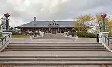
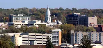
 Downtown Lafayette and the Riehle Plaza & CityBus depot (2011) | |
| Nickname(s): "Star City" | |
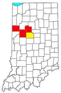
 Location of Lafayette in Tippecanoe County and the state of Indiana | |
| Coordinates: 40°25′2″N 86°52′43″W | |
| Country | United States of America |
| State | Indiana |
| County | Tippecanoe |
| Townships | Fairfield, Perry, Sheffield, Wea |
| Platted | 1825 |
| Incorporated | 1853 |
| Founded by | William Digby |
| Named for | General Lafayette |
| Government | |
| • Type | Mayor/Council |
| • Mayor | Tony Roswarski (D) |
| Area | |
| • Land | 29.38 sq mi (76.1 km2) |
| • Water | 0.13 sq mi (0.3 km2) |
| • Metro | 904.6 sq mi (2,343 km2) |
| Elevation | 692 ft (211 m) |
| Population | |
| • City | 67,140 |
| • Estimate (2019) | 71,721 |
| • Density | 2,441/sq mi (942/km2) |
| • Metro | 201,789 |
| Time zone | UTC−5 (EST) |
| • Summer (DST) | UTC−4 (EDT) |
| ZIP code | 47901, 47904, 47905, 47909 |
| Area code(s) | 765 |
| Interstate Highways | |
| U.S. Highways |
|
| Major State Roads | |
| Waterways | Wabash River |
| Airports | Purdue University Airport (West Lafayette) |
| Public transit | CityBus |
| FIPS code | 18-40788[4] |
| GNIS feature ID[5] | 437501 |
| Website | www |

According to the 2010 United States Census, the population of Lafayette was 67,140, a 19% increase from 56,397 in 2000. Meanwhile, the 2010 Census pegged the year-round (excluding Purdue University students) population of West Lafayette at 29,596 and the Tippecanoe County population at 172,780.[7]
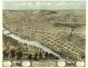
Lafayette was founded in 1825 on the southeast bank of the Wabash River near where the river becomes impassable for riverboats upstream, though a French fort and trading post had existed since 1717 on the opposite bank and three miles downstream. It was named for the French general Marquis de Lafayette, a revolutionary war hero.
History

When European explorers arrived at this area, it was inhabited by a tribe of Miami Indians known as the Ouiatenon or Weas. In 1717, the French government established Fort Ouiatenon across the Wabash River and three miles (5 km) south of present-day Lafayette. The fort became the center of trade for fur trappers, merchants and Indians. An annual reenactment and festival known as Feast of the Hunters' Moon is held there each autumn.[8]
The town of Lafayette was platted in May 1825 by William Digby, a trader. It was designated as the county seat of the newly formed Tippecanoe County the following year. Like many frontier towns, Lafayette was named for General Lafayette, a French officer who significantly aided George Washington's Continental Army during the American Revolutionary War. Lafayette toured the United States in 1824 and 1825.[9]
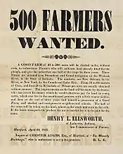
In its earliest days, Lafayette was a shipping center on the Wabash River. In 1838, Henry Leavitt Ellsworth, the first United States Patent Commissioner, published a booklet titled Valley of the Upper Wabash, Indiana, with Hints on Its Agricultural Advantages, to promote settlement of the region. By 1845, Ellsworth had purchased 93,000 acres (380 km2) of farmland around Lafayette and moved there from Connecticut to supervise land sales.[10] By 1847 Ellsworth was distributing broadsides looking for farmers to purchase his farmland.[11] He became president of the Tippecanoe County Agricultural Society in April 1851 – despite some local resentment over what was called "the Yale Crowd" – but he was defeated the same year when he ran for the Indiana House of Representatives.[12] Ellsworth Street and Ellsworth Historic District are named for him.[13]
The Wabash and Erie Canal in the 1840s stimulated trade and affirmed Lafayette's regional prominence. Railroads arrived in the town in the 1850s, connecting it with other major markets. The Monon Railroad connected Lafayette with other sections of Indiana.
Lafayette was the site of the first official air mail delivery in the United States on 17 August 1859, when John Wise piloted a balloon starting on the Lafayette courthouse grounds. Wise hoped to reach New York; however, weather conditions forced the balloon down near Crawfordsville, Indiana, and the mail reached its final destination by train. In 1959, the US Postal Service issued a 7¢ airmail stamp commemorating the centennial of the event.[14]
In 1992, the Greater Lafayette area (Lafayette and West Lafayette) was the first place in Indiana to experience the internet during the initial college town connection launching.
Geography
Lafayette is located at 40°24′38″N 86°52′29″W (40.410585, −86.874681)[15] and is located in Fairfield and Wea Townships. Elevation at the court house is 550 feet (168 m), but city elevations range from a little over 500 feet (150 m) at the Wabash River to approximately 700 feet (210 m) in the areas of Murdock Park and Columbian Park.
According to the 2010 census, Lafayette has a total area of 27.74 square miles (71.85 km2), all land.[16]
Climate and weather
In recent years, temperatures in Lafayette have ranged from an average low of 17 °F (−8 °C) in January to a high of 86 °F (30 °C) in July, although a record low of −33 °F (−36 °C) was recorded in January 1985 and again in January 1994; and a record high of 105 °F (41 °C) was recorded in June 1988. Average monthly precipitation ranged from 1.58 inches (40 mm) in February to 4.24 inches (108 mm) in June.[17]
| Climate data for Lafayette, Indiana | |||||||||||||
|---|---|---|---|---|---|---|---|---|---|---|---|---|---|
| Month | Jan | Feb | Mar | Apr | May | Jun | Jul | Aug | Sep | Oct | Nov | Dec | Year |
| Record high °F (°C) | 69 (21) |
74 (23) |
82 (28) |
89 (32) |
93 (34) |
104 (40) |
106 (41) |
98 (37) |
102 (39) |
92 (33) |
80 (27) |
71 (22) |
106 (41) |
| Average high °F (°C) | 31.6 (−0.2) |
36.9 (2.7) |
48.5 (9.2) |
60.7 (15.9) |
72.3 (22.4) |
81.4 (27.4) |
84.5 (29.2) |
82.5 (28.1) |
76.9 (24.9) |
64.8 (18.2) |
49.9 (9.9) |
36.9 (2.7) |
60.6 (15.9) |
| Average low °F (°C) | 14.3 (−9.8) |
18.3 (−7.6) |
28.7 (−1.8) |
38.7 (3.7) |
49.7 (9.8) |
58.9 (14.9) |
62.4 (16.9) |
60.4 (15.8) |
52.6 (11.4) |
41.3 (5.2) |
31.7 (−0.2) |
20.5 (−6.4) |
39.8 (4.3) |
| Record low °F (°C) | −33 (−36) |
−23 (−31) |
−15 (−26) |
4 (−16) |
24 (−4) |
36 (2) |
42 (6) |
36 (2) |
26 (−3) |
19 (−7) |
−2 (−19) |
−25 (−32) |
−33 (−36) |
| Average precipitation inches (mm) | 1.91 (49) |
1.73 (44) |
2.98 (76) |
3.26 (83) |
4.18 (106) |
4.38 (111) |
3.91 (99) |
3.73 (95) |
2.78 (71) |
2.44 (62) |
3.04 (77) |
2.56 (65) |
36.90 (937) |
| Average snowfall inches (cm) | 6.5 (17) |
4.8 (12) |
2.9 (7.4) |
0.7 (1.8) |
0 (0) |
0 (0) |
0 (0) |
0 (0) |
0 (0) |
0.3 (0.76) |
0.8 (2.0) |
5.2 (13) |
21.2 (54) |
| Average precipitation days (≥ 0.01 in) | 9.6 | 7.7 | 10.2 | 10.9 | 10.6 | 10.4 | 8.9 | 8.4 | 7.6 | 8.3 | 9.8 | 10.1 | 112.5 |
| Average snowy days (≥ 0.1 in) | 5.3 | 3.3 | 1.7 | 0.3 | 0 | 0 | 0 | 0 | 0 | 0.1 | 0.9 | 3.5 | 15.1 |
| Source 1: The Weather Channel (January record high)[18] | |||||||||||||
| Source 2: NOAA[19] | |||||||||||||
Demographics
Lafayette is the larger principal city of the Lafayette-Frankfort CSA, a Combined Statistical Area that includes the Lafayette metropolitan area (Benton, Carroll, and Tippecanoe counties) and the Frankfort micropolitan area (Clinton County),[20][21][22] which had a combined population of 212,408 at the 2000 United States Census.
2010 census
As of the 2010 United States Census,[3] there were 67,140 people, 28,545 households, and 15,863 families in the city. The population density was 2,420.3 inhabitants per square mile (934.5/km2). There were 31,260 housing units at an average density of 1,126.9 per square mile (435.1/km2). The racial makeup of the city was 74.2% White, 11.2% African American, 0.4% Native American, 1% Asian, 0.0% from other races, and 2.7% from two or more races. Hispanic or Latino of any race were 16.3% of the population.
There were 28,545 households, of which 29.4% had children under the age of 18 living with them, 36.7% were married couples living together, 13.7% had a female householder with no husband present, 5.2% had a male householder with no wife present, and 44.4% were non-families. 34.9% of all households were made up of individuals, and 9% had someone living alone who was 65 years of age or older. The average household size was 2.30 and the average family size was 3.00.
The median age in the city was 31.9 years. 23.8% of residents were under the age of 18; 12.9% were between the ages of 18 and 24; 29.9% were from 25 to 44; 22.2% were from 45 to 64; and 11.3% were 65 years of age or older. The gender makeup of the city was 48.7% male and 51.3% female.
2000 census

As of the 2000 United States Census, there were 56,397 people, 24,060 households, and 13,666 families in the city. The population density was 2,806.5 people per square mile (1,083.9/km2). There were 25,602 housing units at an average density of 1,274.1 per square mile (492.0/km2). The racial makeup of the city was 88.91% White; 3.22% African American; 0.37% Native American; 1.22% Asian; 0.04% Pacific Islander; 4.61% from other races, and 1.62% from two or more races. Hispanic or Latino of any race were 9.11% of the population.
There were 24,060 households, out of which 27.0% had children under the age of 18 living with them; 42.5% were married couples living together; 10.2% had a female householder with no husband present; and 43.2% were non-families. 33.2% of all households were made up of individuals, and 9.4% had someone living alone who was 65 years of age or older. The average household size was 2.31 individuals and the average family size was 2.98.
The city population contained 23.2% under the age of 18; 14.2% from 18 to 24; 31.3% from 25 to 44; 19.3% from 45 to 64; and 12.0% who were 65 years of age or older. The median age was 32 years. For every 100 females, there were 97.7 males. For every 100 females age 18 and over, there were 95.3 males.
The median income for a household in the city was $35,859, and the median income for a family was $45,480. Males had a median income of $32,892 versus $23,049 for females. The per capita income for the city was $19,217. About 8.0% of families and 12.1% of the population were below the poverty line, including 15.8% of those under age 18 and 4.6% of those age 65 or over.
Government
The government consists of a mayor – elected in a citywide vote – and a city council of nine members. Six are elected from individual districts; three are elected at-large.

Education
Public
K-12 public education in Lafayette is provided by the Lafayette School Corporation. The Tippecanoe School Corporation also administers county schools nearby. New Community School was a tuition-free elementary charter school (sponsored by Ball State University) located on the north side of Lafayette that permanently closed at the end of 2016.[23] Beacon Academy is a charter school located in West Lafayette.
Private
Public library
The Lafayette area has three branch locations of the Tippecanoe County Public Library:[25]
- Downtown Library[26]
- Wyandotte Branch[27]
- West Lafayette Klondike Branch[28]
News and media
Newspapers
- Journal & Courier. The newspaper, which serves the Greater Lafayette area, has its newsroom and offices located in downtown Lafayette. Journal & Courier also has its own printing services for itself and other papers in the region on the eastside of Lafayette.
- Purdue Exponent. Purdue University's independent student newspaper serves Purdue, West Lafayette, and Lafayette, and has its newsroom and offices located off campus on Northwestern Avenue in West Lafayette.
- The Lafayette Leader
Television
From 1953 until the 2016 launch of WPBI-LD, WLFI-TV had been the only "Big Three" (ABC, CBS and NBC—or, including Fox, "big four") commercial network television broadcaster in the Lafayette market. With the 2017 launch of WPBY-LD, local broadcasts of all "big four" networks became available.[29][30]
WRTV, WTHR, WTTV, and WXIN, the respective ABC, NBC, CBS, and Fox affiliates in Indianapolis which had been carried by cable and satellite providers in the Lafayette market as "out-of-market" stations, remain viewable in the area via a large over-the-air antenna or, in some cases, via a subscription satellite or streaming service. Cable provider Comcast Xfinity discontinued its remaining carriage of Indianapolis-based "big four" stations on March 7, 2018,[31] but resumed carriage of WTHR and WRTV two days later.[32]
Commercial Radio Stations
Non-commercial Radio Stations
- WBAA-AM/FM
- WHPL-FM
- WJEF-FM
- WQSG-FM
- WTGO-LP FM
- WWCC-LP FM
Transportation

Airports
No airports are located within Lafayette city limits. The nearest general aviation airport is Purdue University Airport (LAF) in West Lafayette. The nearest commercial airport which currently has scheduled airline service is Indianapolis International Airport (IND), located approximately 60 miles (97 km) southeast of Lafayette in Indianapolis.
Highways
 Interstate 65 to Gary, Indiana (near Chicago) and Indianapolis
 US 52 to Joliet, Illinois (also near Chicago) and Indianapolis
 US 231 to Rensselaer, Indiana and Owensboro, Kentucky
 State Road 25
 State Road 26
 State Road 38
Railroads
Amtrak, the national passenger rail system, provides passenger rail service to Lafayette through the Cardinal to Chicago, Washington D.C., and New York City. Norfolk Southern; CSX; Kankakee, Beaverville and Southern Railroad; and Toledo, Peoria and Western Railway (RailAmerica) provide freight rail service. Many lines that originally passed through the downtown were redirected in the mid-1990s to a rail corridor near the Wabash River.[33][34]
Bus service
- CityBus local bus service by the Greater Lafayette Public Transportation Corporation[35]
- Greyhound intercity bus service
- Lafayette Limo shuttle service to the Indianapolis International Airport and O'Hare International Airport
- Reindeer Shuttle to the Indianapolis International Airport and O'Hare International Airport
- Express Air Coach shuttle service to the O'Hare International Airport
Economy
Much of the area's economy centers around the academic and industrial activities of Purdue University, although private industry and commerce independent of the university also exist in the community, with multiple large manufacturing operations in the city employing thousands of workers. Some examples:
- Arconic, a producer of aluminum extrusions and tubes
- Caterpillar Large Engine Division, producer of large diesel and natural gas engines
- Wabash National, world's largest manufacturer of semi-truck trailers
- Subaru of Indiana Automotive, producer of Subaru vehicles
- Evonik (Tippecanoe Laboratories) pharmaceuticals/chemicals
- Tate & Lyle, manufacturer of Splenda(R) and other sweeteners; has two plants in Lafayette
- ZF Commercial Steering Systems
- Landis+Gyr, manufacturer of electric meters for global ANSI markets
- Cargill, soybean oil mill
Arts and culture

Arts organizations
- Haan Mansion Museum of Indiana Art
- Tippecanoe Arts Federation
- Art Museum of Greater Lafayette
- The Long Center for the Performing Arts
- Lafayette Symphony Orchestra
Fairs and festivals
- Feast of the Hunters' Moon
- Hands on Transportation
- Mini Maker Faire of Greater Lafayette
- Art in the Park
- OUTfest
- Mosey Down Main Street
- Beers Across the Wabash
- Round the Fountain Art Fair
- A Taste of Tippecanoe
Population history
| Historical population | |||
|---|---|---|---|
| Census | Pop. | %± | |
| 1850 | 6,129 | — | |
| 1860 | 9,387 | 53.2% | |
| 1870 | 13,506 | 43.9% | |
| 1880 | 14,860 | 10.0% | |
| 1890 | 16,243 | 9.3% | |
| 1900 | 18,116 | 11.5% | |
| 1910 | 20,081 | 10.8% | |
| 1920 | 22,486 | 12.0% | |
| 1930 | 26,240 | 16.7% | |
| 1940 | 28,798 | 9.7% | |
| 1950 | 35,558 | 23.5% | |
| 1960 | 42,330 | 19.0% | |
| 1970 | 44,955 | 6.2% | |
| 1980 | 43,011 | −4.3% | |
| 1990 | 43,764 | 1.8% | |
| 2000 | 56,397 | 28.9% | |
| 2010 | 67,140 | 19.0% | |
| 2019 (est.) | 71,721 | [36] | 6.8% |
| Source: US Census Bureau | |||
Notable people from Lafayette
For notable residents associated with Purdue University, see List of Purdue University people.
Entertainment
- Axl Rose – co-founder and lead vocalist of rock band Guns N' Roses
- Izzy Stradlin – songwriter, co-founder and former rhythm guitarist of rock band Guns N' Roses
- Jeremy Camp – Christian recording artist
- Eric Carlson - lead guitarist, songwriter, founding member of The Mentors
- Embeth Davidtz – film and television actor
- Louise Fazenda – film actor whose career spanned silent and talking movies
- Charles Foley – co-inventor of the game Twister
- Mass Giorgini – musician and record producer
- Troy Hickman – writer best known for his comic book work (Common Grounds, Twilight Guardian, City of Heroes, Witchblade, Turok)
- Shannon Hoon – former lead vocalist of rock band Blind Melon
- John Korty – director, screenwriter, known for The Autobiography of Miss Jane Pittman and documentary Who Are the DeBolts? And Where Did They Get Nineteen Kids?
- Claudia Lee – television actress, Hart of Dixie
- Larry McNeely – musician, banjo player with Glen Campbell and for film soundtracks
- Tammy Lynn Michaels – television actor[37]
- Ken Navarro – smooth jazz guitarist[38]
- Chubby Parker – country music radio personality and recording artist
- Sydney Pollack – film actor, director, and producer
- Victor Potel – silent film actor[39]
- Julia Scheeres – author, best known for ALA Alex Award-winning memoir Jesus Land
Sports
- William Fritz Afflis known professionally as "Dick the Bruiser" – professional football player and wrestler; graduated from Lafayette Jefferson HS
- Eric Bruntlett – professional baseball player[40]
- Clem Crowe – professional football and basketball player
- Todd Dunwoody – professional baseball player
- Ray Ewry – 10-time Olympic champion in track and field
- Bernard "Bernie" Flowers – college and professional football player; born in Cleveland area, lived in Lafayette
- Bob Friend – professional baseball player
- Dustin Keller – professional football player; graduated from Lafayette Jefferson HS
- Pete Halsmer – professional race car driver
- Charles Kirkpatrick – professional race car driver
- Josh Lindblom – professional baseball player
- Chukie Nwokorie – professional football player; graduated from Lafayette Jefferson HS
- Clayton Richard – professional baseball player; graduated from McCutcheon HS
- Erik Sabel – professional baseball player
- Justin Smith – football player
- George Souders – professional race car driver (1927)
Business, law, politics
- Roger D. Branigin – Governor of Indiana 1965–1969
- John Burger – member of the Minnesota House of Representatives
- Steve Carter – Indiana Attorney General
- Henry Leavitt Ellsworth – first Commissioner of the United States Patent and Trademark Office; real estate developer
- Henry W. Ellsworth – son of Henry Leavitt Ellsworth, attorney, poet, author and Minister to Sweden
- David W. Evans – US Representative, 6th Congressional District Indiana 1975–1983
- Clara Shortridge Foltz (1849–1934) – first female lawyer on the West Coast
- Joseph García – Former Lt. Governor of Colorado
- Herman Joseph Justin – founded Justin Boot Company
- Brian Lamb – founder of C-SPAN
- Bill Long – state representative
- Frank Posegate – journalist, mayor of St. Joseph, Missouri
- John Purdue – Purdue Block, Tippecanoe County founder, founding benefactor of Purdue University
- Barbara Ringer – first female register of copyrights
- Alvah Curtis Roebuck – founded Sears, Roebuck and Company
Academic, science, technology
- Eric J. Barron – 14th President of Florida State University, 18th President of Penn State
- Herbert C. Brown – Nobel Prize laureate in chemistry
- Christopher L. Eisgruber – 20th President of Princeton University
- Daniel X. Freedman – pioneer in biological psychiatry, discovered link of hallucinogens to brain transmitters
- Andrew McCammon – physical and theoretical chemist
- Donald E. Williams – astronaut
- Ian Murdock – software engineer, created Debian
Other
- Emily Thornton Charles, poet, journalist
- Benjaman Kyle, known for identity loss due to dissociative amnesia
Points of interest


- Purdue University, located in West Lafayette
- Jerry E. Clegg Botanic Garden;
- Horticulture Gardens at Purdue University
Prophet's Rock
10 minutes North of Lafayette lies Prophet Rock, where the Prophet Tenskwatawa, the half brother of Tecumseh, stood watch encouraging the local Shawnee Native Americans to fight against the encamped army forces of William Henry Harrison in the Battle Of Tippecanoe in 1811. Tenskwatawa was a spiritual leader, but not a military man. His brother was out of town as the U.S. Army forces marched North, with hopes to destroy Prophetstown. Tenskwatawa had sought to have a meeting with Harrison to discuss how to avoid going to war. In the evening before the war, he sought a spiritual vision that led him to believe that Harrison must be assassinated. Early in the morning of November 6, the warriors attacked Harrison's militia and war ensued. The warriors fell weak in supplies against the militia, and succumbed. Prophetstown was taken over where the militia stole supplies and burnt it down. The rock where Tenskwatawa stood still stands over the battlefield, though now covered with much taller trees. The rock can be accessed by scaling its front or by hiking the ridge that leads to the top.[41]
Headstone of Martin P. Jenners
The Martin Jenners headstone is at the Spring Vale Cemetery in Lafayette.[42] Jenners was a Civil War veteran[43][44][45] who was known as the first white person born in Tippecanoe County and as an outspoken atheist.[46] Originally located in Greenbush Cemetery,[47] his headstone is unique because he had it placed in the cemetery fourteen years before his death, with this inscription: "My only objection to religion is that it is not true. No preaching, no praying, no psalm singing on this lot." Jenners' headstone cites two verses that contradict each other, hence making the Bible untrue: I Corinthians 15:52, which talks about believers being raised from the dead "in a twinkling of an eye", and Isaiah 26:14, which states "They are now dead, they live no more; their spirits do not rise." The headstone received national attention at the time, despite attempts to have it removed, and it continued to draw visitors from around the country.[48][49] Jenners' headstone inscription has been cited by believers as an example of Bible writings being taken out of context.[50][51][52]

Notable buildings
- Judge Cyrus Ball House, listed on the National Register of Historic Places
- James H. Ward House, listed on the National Register of Historic Places
- Temple Israel, 17 South 7th St. - one of the nation's oldest surviving synagogue buildings.
- Trinity United Methodist Church (Trinity Methodist Episcopal Church until 1969) – the first church congregation in the Lafayette area. Its current building was erected in 1869 by William Heath and has remained intact to this day.
- Tippecanoe Mall - the city's main shopping center.
- Tippecanoe County Courthouse - built 1882-1884 at a cost of around $500,000 (double the original estimate).
Gallery
 Lafayette skyline from West Lafayette
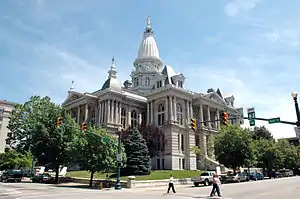 The Court House - Downtown
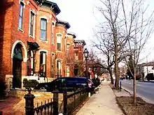 South Street historic row
 wind turbines at CityBus
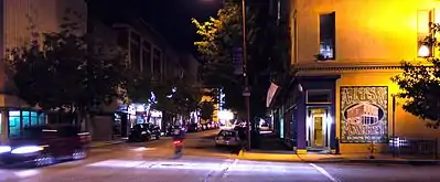 Main Street at night
 Clegg Garden
 View of Lafayette from Main St bridge
Sister cities
Lafayette has two sister cities as designated by Sister Cities International.[53][54]
See also
- Neighborhoods of Lafayette
- Historic Neighborhoods
- Centennial Neighborhood District
- Downtown Lafayette Historic District
- Ellsworth Historic District
- Highland Park Neighborhood Historic District
- Jefferson Historic District
- Ninth Street Hill Neighborhood Historic District
- Perrin Historic District
- St. Mary Historic District
- Upper Main Street Historic District
References
- "2019 US Gazetteer Files". US Census Bureau. Retrieved July 16, 2020.
- "US Board on Geographic Names". US Geological Survey. 25 October 2007. Retrieved 31 January 2008.
- "US Census website". US Census Bureau. Retrieved 11 December 2012.
- "US Census website". US Census Bureau. Retrieved 31 January 2008.
- "Lafayette, Indiana". Geographic Names Information System. United States Geological Survey. Retrieved 25 July 2016.
- Smith 3, Fletcher (2014). "Find a name". National Association of Counties. Retrieved 7 June 2011.
- "Lafayette IN – QuickFacts". US Census Bureau. Archived from the original on 26 September 2012. Retrieved 19 April 2012.
- "Feast of the Hunters' Moon". Tippecanoe County Historical Association. Archived from the original on 20 June 2009. Retrieved 1 June 2009.
- "Lafayette History". Home Of Purdue. Retrieved 29 July 2019.
- A Day in the Life of Tippecanoe County Archived 6 September 2006 at the Wayback Machine, Tippecanoe County Historical Association
- Guide to the Henry Leavitt Ellsworth Papers, Yale University Library
- A Day in the Life of Tippecanoe County, Tippecanoe County Historical Association Archived 6 November 2007 at the Wayback Machine
- During the period of Ellsworth's residence in Lafayette, two of his children came to national attention. His son Henry William Ellsworth was confirmed as United States chargé d'affaires at Stockholm, Sweden, in January 1846; and Ellsworth's daughter Annie suggested the words of the first telegraph message sent by her father's friend Samuel F. B. Morse in May 1844.
- First Air Mail Flight Archived 18 November 2007 at the Wayback Machine
- "US Gazetteer files: 2010, 2000, and 1990". US Census Bureau. 12 February 2011. Retrieved 23 April 2011.
- "Geographic Identifiers – 2010 Census Summary File 1". US Census Bureau. Archived from the original on 13 February 2020. Retrieved 29 July 2015.
- "Monthly Averages for Lafayette IN". The Weather Channel. Retrieved 27 January 2011.
- "Monthly Averages for Lafayette IN (47905)". The Weather Channel. Retrieved 19 November 2011.
- "Climatology of the United States No. 20: Lafayette 8 S, IN 1971–2000" (PDF). National Oceanic and Atmospheric Administration. Retrieved 19 November 2011.
- Metropolitan Statistical Areas and Components Archived 26 May 2007 at the Wayback Machine, Office of Management and Budget, 11 May 2007. Accessed 1 August 2008.
- Micropolitan Statistical Areas and Components Archived 29 June 2007 at the Wayback Machine, Office of Management and Budget, 11 May 2007. Accessed 1 August 2008.
- Combined Statistical Areas and Component Core Based Statistical Areas Archived 29 June 2007 at the Wayback Machine, Office of Management and Budget, 11 May 2007. Accessed 1 August 2008.
- New Community School Closed (12 December 2016)
- Central Catholic Schools (lcss.org)
- "Home- Tippecanoe County Public Library". Tippecanoe County Public Library. Retrieved 4 April 2018.
- "Downtown Library - Tippecanoe County Public Library". Tippecanoe County Public Library. Retrieved 4 April 2018.
- "Wyandotte Branch - Tippecanoe County Public Library". Tippecanoe County Public Library. Retrieved 4 April 2018.
- "Klondike Branch - Tippecanoe County Public Library". Tippecanoe County Public Library. Retrieved 4 April 2018.
- "Lafayette, Ind. Gets Its Own ABC Affiliate". Broadcasting & Cable. Retrieved May 25, 2017.
- "WPBI begins news broadcast, launches ABC affiliate". Journal & Courier. Retrieved May 30, 2017.
- "Comcast kills last of Indy stations from Lafayette's cable lineup". Journal & Courier. Retrieved March 8, 2018.
- "Comcast: Indianapolis broadcast stations back … at least for now". Journal & Courier. Retrieved March 9, 2018.
- Amtrak in Lafaytte IN (1994) gregarnst
- Amtrak in Lafaytte IN (May 1995) gregarnst
- Online Live Bus timings updates Archived 17 March 2013 at the Wayback Machine, 11 May 2007.
- "Population and Housing Unit Estimates". US Census Bureau. May 24, 2020. Retrieved 27 May 2020.
- imdb page of Tammy Lynn Michaels
- Home Page: Ken Navarro Archived 8 February 2011 at the Wayback Machine
- imdb page of Victor Potel
- "Eric Bruntlett Stats". Baseball Almanac. Retrieved 27 December 2012.
- "Prophet's Rock". Retrieved 9 May 2016.
- Horror in the Heartland
- "The Civil War: Jenners, Martin P." National Park Service. Retrieved January 12, 2015.
- "76th Regiment, Indiana Infantry (30 days, 1862)." Retrieved January 13, 2015.
- "76th Regiment."
- "Oldest White Child Born in Lafayette Found Dead." The Indianapolis Star, December 23, 1919. www.newspapers.com. Retrieved January 16, 2015.
- "Object to epitaph he has carved on headstone - says the Bible is fiction." The Indianapolis News, September 2, 1905. www.newspapers.com. Retrieved November 26, 2014.
- "Tombstone Says Bible is False." Syracuse Telegram and Courier, September 29, 1905. www.fultonhistory.com. Retrieved January 16, 2015.
- Jensen, Laurie. "Early Settler's Last Words Continue to Draw a Crowd." Archived 18 January 2015 at Archive.today www.roguehangar.com. Retrieved January 16, 2015.
- Stone, Perry. "Using the Wrong Sword for the Wrong Battle." www.ministrytodaymag.com. Retrieved November 22, 2014.
- Stone, Perry. Secrets From Beyond the Grave. Lake Mary, FL: Charisma House, 2010. ISBN 1616381574. Google Books. Retrieved November 22, 2014.
- Stone, Perry. There's a Crack in Your Armor. Lake Mary, FL: Charisma House, 2014. ISBN 1621362485. Google Books. Retrieved November 22, 2014.
- "2018 Annual Report and Membership Directory" (PDF). Sister Cities International. p. 47. Retrieved June 29, 2018.
- "Interactive City Directory". Sister Cities International. Archived from the original on 16 August 2016. Retrieved 7 July 2016.
- アメリカ合衆国インディアナ州グレイターラフィエット [Greater Lafayette, Indiana, United States of America] (in Japanese). City of Ōta, Gunma. Retrieved 20 June 2016.
External links
| Wikimedia Commons has media related to Lafayette, Indiana. |
 Lafayette (Indiana) travel guide from Wikivoyage
- City of Lafayette, Indiana website
- Lafayette Online
Municipalities and communities of Tippecanoe County, Indiana, United States | ||
|---|---|---|
| Cities | Map of Indiana highlighting Tippecanoe County | |
| Towns | ||
| Townships | ||
| CDPs | ||
| Other unincorporated communities | ||
| Ghost towns | ||
| Footnotes | ‡This populated place also has portions in an adjacent county or counties | |
| ||

| Authority control |
|---|