Tranøy
Tranøy is a former municipality that was located in the old Troms county, Norway. The municipality is situated on the southern coast of the large island of Senja. The municipality existed from 1838 until its dissolution in 2020 when it was merged into the new Senja Municipality. The administrative centre was the village of Vangsvik in the eastern part of the municipality. Other important villages included Stonglandseidet, Skrollsvika, and Å.
Tranøy kommune
Ránáidsullo suohkan | |
|---|---|
 Troms within Norway | |
 Tranøy within Troms | |
| Coordinates: 69°11′29″N 17°21′44″E | |
| Country | Norway |
| County | Troms |
| District | Midt-Troms |
| Established | 1 Jan 1838 |
| Disestablished | 1 Jan 2020 |
| Administrative centre | Vangsvik |
| Area | |
| • Total | 523.87 km2 (202.27 sq mi) |
| • Land | 499.27 km2 (192.77 sq mi) |
| • Water | 24.60 km2 (9.50 sq mi) 4.7% |
| Area rank | 204 in Norway |
| *Area at municipal dissolution. | |
| Population (2018) | |
| • Total | 1,536 |
| • Rank | 352 in Norway |
| • Density | 3.1/km2 (8/sq mi) |
| • Change (10 years) | −2.7% |
| Demonym(s) | Tranøyværing[1] |
| Time zone | UTC+01:00 (CET) |
| • Summer (DST) | UTC+02:00 (CEST) |
| ISO 3166 code | NO-1927 |
| Official language form | Neutral[2] |
| Created as | Formannskapsdistrikt in 1838 |
| Succeeded by | Senja in 2020 |

The nearly-abandoned island of Tranøya, with the 18th-century wooden Tranøy Church, used to be the centre of activities for the municipality. From Tranøybotn it is only a short walk to the Ånderdalen National Park, with varied landscapes within a very limited area, including deep pine forests.
At the time of its dissolution as a municipality on 1 January 2020, the 524-square-kilometre (202 sq mi) municipality was the 204th largest by area out of the 422 municipalities in Norway. Tranøy was also the 352nd most populous municipality in Norway with a population of 1,536. The municipality's population density was 3.1 inhabitants per square kilometre (8.0/sq mi) and its population has decreased by 2.7% over the previous decade.[3][4]
General information
The large municipality of Tranøy was established on 1 January 1838 (see formannskapsdistrikt). The original municipality included all the land surrounding the large Solbergfjorden. On 1 September 1886, the municipality was divided into three separate municipalities: Tranøy (population: 1,239) on the west, Dyrøy (population: 1,281) in the south, and Sørreisa (population: 1,361) in the east.
During the 1960s, there were many municipal mergers across Norway due to the work of the Schei Committee. On 1 January 1964 several changes took place:[5]
- The mainland areas of Tranøy (population: 382) were transferred to Dyrøy Municipality.
- The Hellemo, Paulsrud, Johnsgård, and Stormo farms (population: 106) were transferred to Lenvik Municipality.
- The parts of Bjarkøy Municipality on the island of Senja and Lemmingsvær islands (population: 480) were transferred to Tranøy Municipality.
- The Rødsand area of Torsken Municipality (population: 160) was also transferred to Tranøy Municipality.
In March 2017, the Parliament of Norway voted to merge the municipalities of Berg, Torsken, Lenvik, and Tranøy. The new municipality will encompass the whole island of Senja plus part of the mainland. The new municipality will be established on 1 January 2020 and it will be called Senja Municipality.[6][7]
Name
The municipality (originally the parish) is named after the small island of Tranøya (Old Norse: Tranøiar), since the first Tranøy Church was built there. The first element is comes from trana which means "crane" and the last element is øy which means "island". Prior to 1909, the name was written Tranø.[8]
Coat of arms
The coat of arms is from modern times; they were granted on 15 May 1987. The arms are silver or white with a black Atlantic halibut (Hippoglossus hippoglossus) in the center. The fish is a main species of local fish, which symbolizes the importance of fishing for the local community. In addition to this, the fish played a major role in local legends, similar to the role of bears in land-based legends.[9]
Churches
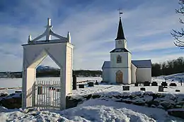
The Church of Norway has one parish (sokn) within the municipality of Tranøy. It is part of the Senja prosti (deanery) in the Diocese of Nord-Hålogaland.
| Parish (Sokn) | Church Name | Location of the Church | Year Built |
|---|---|---|---|
| Tranøy | Stonglandet Church | Stonglandseidet | 1896 |
| Tranøy Church | Tranøya | 1775 | |
| Skrolsvik Chapel | Skrollsvika | 1924 | |
| Vangsvik Chapel | Vangsvik | 1975 |
Geography
The municipality of Tranøy is located on the southern end of the large island of Senja. The Andfjorden, Vågsfjorden, and Solbergfjorden surround the municipality to the west, south, and southeast. The municipalities of Torsken and Berg lie to the north and the municipality of Lenvik is to the east. Ånderdalen National Park lies in the northwestern part of the municipality.
Climate
| Climate data for Vangsvika | |||||||||||||
|---|---|---|---|---|---|---|---|---|---|---|---|---|---|
| Month | Jan | Feb | Mar | Apr | May | Jun | Jul | Aug | Sep | Oct | Nov | Dec | Year |
| Daily mean °C (°F) | −3.9 (25.0) |
−3.8 (25.2) |
−2.0 (28.4) |
1.2 (34.2) |
5.7 (42.3) |
10.0 (50.0) |
12.5 (54.5) |
11.6 (52.9) |
7.5 (45.5) |
3.5 (38.3) |
−0.4 (31.3) |
−2.8 (27.0) |
3.3 (37.9) |
| Average precipitation mm (inches) | 106 (4.2) |
95 (3.7) |
76 (3.0) |
65 (2.6) |
45 (1.8) |
53 (2.1) |
67 (2.6) |
75 (3.0) |
100 (3.9) |
137 (5.4) |
117 (4.6) |
114 (4.5) |
1,050 (41.3) |
| Source: Norwegian Meteorological Institute[10] | |||||||||||||
Government
All municipalities in Norway, including Tranøy, are responsible for primary education (through 10th grade), outpatient health services, senior citizen services, unemployment and other social services, zoning, economic development, and municipal roads. The municipality is governed by a municipal council of elected representatives, which in turn elect a mayor.[11] The municipality falls under the Senja District Court and the Hålogaland Court of Appeal.
Municipal council
The municipal council (Kommunestyre) of Tranøy was made up of 17 representatives that were elected to four year terms. The party breakdown of the final municipal council was as follows:
| Party Name (in Norwegian) | Number of representatives | |
|---|---|---|
| Labour Party (Arbeiderpartiet) | 6 | |
| Progress Party (Fremskrittspartiet) | 1 | |
| Conservative Party (Høyre) | 4 | |
| Centre Party (Senterpartiet) | 2 | |
| Socialist Left Party (Sosialistisk Venstreparti) | 1 | |
| Tranøy Local List (Tranøy Folkeliste) | 2 | |
| Total number of members: | 17 | |
| Party Name (in Norwegian) | Number of representatives | |
|---|---|---|
| Labour Party (Arbeiderpartiet) | 6 | |
| Progress Party (Fremskrittspartiet) | 1 | |
| Conservative Party (Høyre) | 3 | |
| Centre Party (Senterpartiet) | 2 | |
| Socialist Left Party (Sosialistisk Venstreparti) | 1 | |
| Liberal Party (Venstre) | 1 | |
| Tranøy People's List (Tranøy Folkeliste) | 3 | |
| Total number of members: | 17 | |
| Party Name (in Norwegian) | Number of representatives | |
|---|---|---|
| Labour Party (Arbeiderpartiet) | 7 | |
| Progress Party (Fremskrittspartiet) | 2 | |
| Conservative Party (Høyre) | 1 | |
| Centre Party (Senterpartiet) | 4 | |
| Socialist Left Party (Sosialistisk Venstreparti) | 2 | |
| Liberal Party (Venstre) | 1 | |
| Total number of members: | 17 | |
| Party Name (in Norwegian) | Number of representatives | |
|---|---|---|
| Labour Party (Arbeiderpartiet) | 6 | |
| Progress Party (Fremskrittspartiet) | 2 | |
| Conservative Party (Høyre) | 1 | |
| Christian Democratic Party (Kristelig Folkeparti) | 1 | |
| Centre Party (Senterpartiet) | 4 | |
| Socialist Left Party (Sosialistisk Venstreparti) | 2 | |
| Liberal Party (Venstre) | 1 | |
| Total number of members: | 17 | |
| Party Name (in Norwegian) | Number of representatives | |
|---|---|---|
| Labour Party (Arbeiderpartiet) | 9 | |
| Progress Party (Fremskrittspartiet) | 1 | |
| Conservative Party (Høyre) | 2 | |
| Christian Democratic Party (Kristelig Folkeparti) | 1 | |
| Centre Party (Senterpartiet) | 4 | |
| Socialist Left Party (Sosialistisk Venstreparti) | 1 | |
| Solli local list (Solli bygdelags liste) | 1 | |
| South Tranøy cross-party list (Sør-Tranøy Tverrpolitiske liste) | 1 | |
| Tranøy common list (Tranøy fellesliste) | 1 | |
| Total number of members: | 21 | |
| Party Name (in Norwegian) | Number of representatives | |
|---|---|---|
| Labour Party (Arbeiderpartiet) | 10 | |
| Conservative Party (Høyre) | 2 | |
| Christian Democratic Party (Kristelig Folkeparti) | 1 | |
| Centre Party (Senterpartiet) | 4 | |
| Socialist Left Party (Sosialistisk Venstreparti) | 1 | |
| Tranøy common list (Tranøy Fellesliste) | 3 | |
| Total number of members: | 21 | |
| Party Name (in Norwegian) | Number of representatives | |
|---|---|---|
| Labour Party (Arbeiderpartiet) | 11 | |
| Conservative Party (Høyre) | 1 | |
| Christian Democratic Party (Kristelig Folkeparti) | 1 | |
| Centre Party (Senterpartiet) | 3 | |
| Socialist Left Party (Sosialistisk Venstreparti) | 1 | |
| Tranøy Social Democrat Common List (Tranøy Sosialdemokratiske Fellesliste) | 4 | |
| Total number of members: | 21 | |
| Party Name (in Norwegian) | Number of representatives | |
|---|---|---|
| Labour Party (Arbeiderpartiet) | 10 | |
| Conservative Party (Høyre) | 1 | |
| Christian Democratic Party (Kristelig Folkeparti) | 1 | |
| Centre Party (Senterpartiet) | 3 | |
| Tranøy social democrat common list (Tranøy sosialdemokratisk fellesliste) | 5 | |
| Rødsand cross-party local list (Rødsand tverrpolitisk bygdeliste) | 1 | |
| Total number of members: | 21 | |
| Party Name (in Norwegian) | Number of representatives | |
|---|---|---|
| Labour Party (Arbeiderpartiet) | 14 | |
| Conservative Party (Høyre) | 2 | |
| Christian Democratic Party (Kristelig Folkeparti) | 1 | |
| Centre Party (Senterpartiet) | 3 | |
| Rødsand cross-party local list (Rødsand tverrpolitisk bygdeliste) | 1 | |
| Total number of members: | 21 | |
| Party Name (in Norwegian) | Number of representatives | |
|---|---|---|
| Labour Party (Arbeiderpartiet) | 13 | |
| Conservative Party (Høyre) | 2 | |
| Christian Democratic Party (Kristelig Folkeparti) | 1 | |
| Centre Party (Senterpartiet) | 3 | |
| Non-party local list for Å (Upolitisk bygdeliste for Å) | 1 | |
| Rødsand non-party local list (Rødsand upolitiske bygdeliste) | 1 | |
| Total number of members: | 21 | |
| Party Name (in Norwegian) | Number of representatives | |
|---|---|---|
| Labour Party (Arbeiderpartiet) | 12 | |
| Centre Party (Senterpartiet) | 5 | |
| Socialist Left Party (Sosialistisk Venstreparti) | 1 | |
| Vikstranda non-party list (Vikstranda Upolitiske Liste) | 1 | |
| Non-party list for the Å area (Upolitisk Liste for Å Krets) | 1 | |
| Rødsand non-party list (Rødsand Upolitiske List) | 1 | |
| Total number of members: | 21 | |
| Party Name (in Norwegian) | Number of representatives | |
|---|---|---|
| Labour Party (Arbeiderpartiet) | 8 | |
| Local List(s) (Lokale lister) | 13 | |
| Total number of members: | 21 | |
| Party Name (in Norwegian) | Number of representatives | |
|---|---|---|
| Labour Party (Arbeiderpartiet) | 7 | |
| Local List(s) (Lokale lister) | 14 | |
| Total number of members: | 21 | |
| Party Name (in Norwegian) | Number of representatives | |
|---|---|---|
| Labour Party (Arbeiderpartiet) | 6 | |
| Local List(s) (Lokale lister) | 15 | |
| Total number of members: | 21 | |
| Party Name (in Norwegian) | Number of representatives | |
|---|---|---|
| Labour Party (Arbeiderpartiet) | 6 | |
| List of workers, fishermen, and small farmholders (Arbeidere, fiskere, småbrukere liste) | 7 | |
| Local List(s) (Lokale lister) | 4 | |
| Total number of members: | 17 | |
| Party Name (in Norwegian) | Number of representatives | |
|---|---|---|
| Labour Party (Arbeiderpartiet) | 3 | |
| Communist Party (Kommunistiske Parti) | 1 | |
| List of workers, fishermen, and small farmholders (Arbeidere, fiskere, småbrukere liste) | 1 | |
| Local List(s) (Lokale lister) | 7 | |
| Total number of members: | 17 | |
| Party Name (in Norwegian) | Number of representatives | |
|---|---|---|
| Labour Party (Arbeiderpartiet) | 5 | |
| Communist Party (Kommunistiske Parti) | 2 | |
| Local List(s) (Lokale lister) | 9 | |
| Total number of members: | 16 | |
| Party Name (in Norwegian) | Number of representatives | |
|---|---|---|
| Labour Party (Arbeiderpartiet) | 4 | |
| Liberal Party (Venstre) | 2 | |
| List of workers, fishermen, and small farmholders (Arbeidere, fiskere, småbrukere liste) | 4 | |
| Local List(s) (Lokale lister) | 6 | |
| Total number of members: | 16 | |
| Party Name (in Norwegian) | Number of representatives | |
|---|---|---|
| List of workers, fishermen, and small farmholders (Arbeidere, fiskere, småbrukere liste) | 4 | |
| Local List(s) (Lokale lister) | 12 | |
| Total number of members: | 16 | |
| Party Name (in Norwegian) | Number of representatives | |
|---|---|---|
| Labour Party (Arbeiderpartiet) | 7 | |
| Local List(s) (Lokale lister) | 9 | |
| Total number of members: | 16 | |
References
- "Navn på steder og personer: Innbyggjarnamn" (in Norwegian). Språkrådet.
- "Forskrift om målvedtak i kommunar og fylkeskommunar" (in Norwegian). Lovdata.no.
- Statistisk sentralbyrå (2018). "Table: 06913: Population 1 January and population changes during the calendar year (M)" (in Norwegian). Retrieved 2018-12-10.
- Statistisk sentralbyrå. "09280: Area of land and fresh water (km²) (M)" (in Norwegian). Retrieved 2018-12-10.
- Jukvam, Dag (1999). "Historisk oversikt over endringer i kommune- og fylkesinndelingen" (PDF) (in Norwegian). Statistisk sentralbyrå.
- "Senja kommune 2020" (in Norwegian). Retrieved 2017-09-09.
- Vermes, Thomas (2017-03-29). "Stortingsflertallet gjør fire Senja-kommuner til én". ABC Nyheter (in Norwegian). Retrieved 2017-09-09.
- Rygh, Oluf (1911). Norske gaardnavne: Troms amt (in Norwegian) (17 ed.). Kristiania, Norge: W. C. Fabritius & sønners bogtrikkeri. p. 67.
- "Civic heraldry of Norway - Norske Kommunevåpen". Heraldry of the World. Retrieved 2018-08-25.
- "eKlima Web Portal". Norwegian Meteorological Institute. Archived from the original on 2004-06-14.
- Hansen, Tore, ed. (2016-05-12). "kommunestyre". Store norske leksikon (in Norwegian). Kunnskapsforlaget. Retrieved 2018-08-25.
- "Table: 04813: Members of the local councils, by party/electoral list at the Municipal Council election (M)" (in Norwegian). Statistics Norway.
- "Tall for Norge: Kommunestyrevalg 2011 - Troms Romsa". Valg Direktoratet. Retrieved 2019-10-26.
- "Kommunestyrevalget 1995" (PDF) (in Norwegian). Oslo-Kongsvinger: Statistisk sentralbyrå. 1996. Retrieved 2020-03-18.
- "Kommunestyrevalget 1991" (PDF) (in Norwegian). Oslo-Kongsvinger: Statistisk sentralbyrå. 1993. Retrieved 2020-03-18.
- "Kommunestyrevalget 1987" (PDF) (in Norwegian). Oslo-Kongsvinger: Statistisk sentralbyrå. 1988. Retrieved 2020-03-18.
- "Kommunestyrevalget 1983" (PDF) (in Norwegian). Oslo-Kongsvinger: Statistisk sentralbyrå. 1984. Retrieved 2020-03-18.
- "Kommunestyrevalget 1979" (PDF) (in Norwegian). Oslo: Statistisk sentralbyrå. 1979. Retrieved 2020-03-18.
- "Kommunevalgene 1975" (PDF) (in Norwegian). Oslo: Statistisk sentralbyrå. 1977. Retrieved 2020-03-18.
- "Kommunevalgene 1972" (PDF) (in Norwegian). Oslo: Statistisk sentralbyrå. 1973. Retrieved 2020-03-18.
- "Kommunevalgene 1967" (PDF) (in Norwegian). Oslo: Statistisk sentralbyrå. 1967. Retrieved 2020-03-18.
- "Kommunevalgene 1963" (PDF) (in Norwegian). Oslo: Statistisk sentralbyrå. 1964. Retrieved 2020-03-18.
- "Kommunevalgene og Ordførervalgene 1959" (PDF) (in Norwegian). Oslo: Statistisk sentralbyrå. 1960. Retrieved 2020-03-18.
- "Kommunevalgene og Ordførervalgene 1955" (PDF) (in Norwegian). Oslo: Statistisk sentralbyrå. 1957. Retrieved 2020-03-18.
- "Kommunevalgene og Ordførervalgene 1951" (PDF) (in Norwegian). Oslo: Statistisk sentralbyrå. 1952. Retrieved 2020-03-18.
- "Kommunevalgene og Ordførervalgene 1947" (PDF) (in Norwegian). Oslo: Statistisk sentralbyrå. 1948. Retrieved 2020-03-18.
- "Kommunevalgene og Ordførervalgene 1945" (PDF) (in Norwegian). Oslo: Statistisk sentralbyrå. 1947. Retrieved 2020-03-18.
- "Kommunevalgene og Ordførervalgene 1937" (PDF) (in Norwegian). Oslo: Statistisk sentralbyrå. 1938. Retrieved 2020-03-18.
External links
| Wikimedia Commons has media related to Tranøy. |
- Municipal fact sheet from Statistics Norway (in Norwegian)
 The dictionary definition of tranøy at Wiktionary
 Troms travel guide from Wikivoyage
Troms og Finnmark county, Norway | |||||||||||||||||||||||
|---|---|---|---|---|---|---|---|---|---|---|---|---|---|---|---|---|---|---|---|---|---|---|---|
 |
|   | |||||||||||||||||||||
||
| Authority control |
|---|