Tsankawi
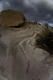
Tsankawi is a detached portion of Bandelier National Monument in New Mexico, near White Rock. It is accessible from a roadside parking area just north of the intersection of East Jemez Road and State Road 4. A self-guided 1.5-mile loop trail provides access to numerous unexcavated ruins, caves carved into soft tuff, and petroglyphs.
Origin of the name
The name Tsankawi [səŋˡkɑwi] (Sa'ekewikwaje Owingeh) may mean "village between two canyons at the clump of sharp round cacti" or more simply, (san-ke-wii) "Opuntia sharp gap" in the Tewa language of the nearby San Idelfonso puebloans.
History
Tsankawi (san-KAH-wee) was built by ancient Pueblo Indians sometimes known as the Ancestral Pueblo People. Archeological evidence indicates that Tsankawi may have been constructed in the 15th century and occupied until the late 16th century—toward the end of the Rio Grande Classic Period. It was occupied by Ancestral Pueblo people. Dendrochronology (tree-ring dating) indicates that a severe drought occurred in the late 16th century. Traditions at a number of nearby Tewa Pueblos, including San Ildefonso Pueblo, Santa Clara Pueblo, Pojoaque Pueblo, and Tesuque Pueblo claim ancestral ties to Tsankawi and other nearby pueblo sites.
Archeological evidence indicates that the Indians first settled the surrounding area in small communities during the late 12th century. Over time fewer, but larger communities were built. Tsankawi was one of these larger communities. The trail follows centuries-old paths through the area where the ancestral Pueblo people lived.
According to Pueblo tradition, the people of Tsankawi spoke Tewa, while those in Frijoles Canyon, the main section of Bandelier, spoke Keres. While their languages were different, their religious beliefs, lifestyles, and worldviews were similar. Even today, active pueblos San Ildefonso, Cochiti, and others retain strong social and traditional ties with these two cultural sites.
The 1.5-mile trail through Tsankawi takes you along centuries-old paths of the ancestral Pueblo people. In many areas, the trails have been worn into the rock 8 to 24 inches or more as the people traveled from the mesa tops to their farms in the canyons below. The trails also connected to other villages in the surrounding area. The natives either wore sandals or walked barefoot
Much of the site has never been excavated, however Edgar Hewett did excavate at least 2 burial mounds near the main pueblo room blocks during his studies of the area in the late 1800s and early 1900s.[1]
Tsankawi village
.jpg.webp)
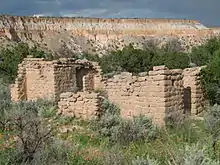
The village was built out of tuff stone plastered inside and out with mud. It was roughly rectangular in shape with about 350 rooms and an enclosed central courtyard or plaza. Not only were the rooms used for cooking and sleeping, but for storage of food for the winter months or when crops failed. The architectural design with rooms surrounding a central plaza is still used by present-day Indians.
The buildings were two or perhaps three stories high with roofs made out of wood and mud. But why have a village on the top of a mesa where, with the exception of rain collected into a small reservoir, water had to be hauled from the springs or rivers below. There has not been any archeological evidence of warfare, but further research is needed.
The Tsankawi inhabitants were totally dependent upon the environment for survival. The climate was dry averaging 15 inches of rainfall a year, yet the inhabitants were able to develop an agricultural way of life. They made use of native plants such as the pinion pine, juniper, rabbit brush, saltbush, mountain mahogany, and yucca for food, dyes, medicine, and tools. They also cultivated corn, beans and squash. Yet in this sparse environment, natural resources were scarce, and over time the Puebloans depleted their resources. Firewood became hard to find and the soil became exhausted due to centuries of farming. During the 16th century an extended drought, indicated by tree ring dating, forced the inhabitants to move on. The pueblo at San Ildefonso, 8 miles away, have the tradition that their ancestors lived at Tsankawi and the surrounding area.
The people of Tsankawi were not isolated. There were many villages on nearby mesas or in the canyons. The people traded tools, blankets, pottery, feathers, turquoise, seashells, and agricultural products. They joined together for religious activities. The village plaza may have been a gathering place for dancing and ceremonies.
Since there was no metal, tools were made from local materials. Obsidian formed by the Jemez volcanoes was used to make arrow points, knives, and scrapers. Volcanic basalt was used as manos and metates to grind seeds and corn. It was also used to enlarge the soft tuff caves and to shape blocks used in building.
After the inhabitants left in the late 16th century, the buildings fell into ruin. The roofs collapsed and the walls crumbled. Wind blown materials filled the cracks and crevices so that only mounds of rubble can be seen with pieces of pottery lying on the ground.
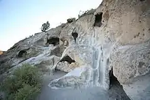
Tsankawi cave dwellings
.jpg.webp)
The ancient pueblo inhabitants of Tsankawi not only had a settlement on top of the mesa, but built their homes along the base of the cliffs. They dug caves into the soft tuff stone and extended the dwelling with walls made of talus rock mortared with mud. (Talus are the loose stones found at the base of a cliff.) The roofs were made with timber and mud. These dwellings are called talus pueblos. 354 talus pueblos have been documented on Tsankawi Mesa with most being located at the weak boundary between the Tshirege and Otowi members of the Bandelier Tuff that forms the bedrock of the mesa.[1] Since the time that the talus pueblos were inhabited, the masonry walls have collapsed. The only thing that remains are caves, or cavates, carved into the cliffs and socket holes which were used to support timbers for the roof. Where not exposed to the elements, the caves are blackened from fires used for cooking and for heat during the winter months. The talus pueblos were built on the south facing side of the mesas. During winter months the afternoon sun would warm the southern cliffs melting the snow, but the northern facing cliffs frequently had snow all winter long. The walls were frequently plastered with clay perhaps for aesthetic reasons or to help prevent the walls from crumbling. Artwork along the walls can be seen in a number of the caves in the form of pictographs carved into the rock and painting remnants where clay still sticks to the walls.
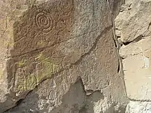
Tsankawi petroglyphs
Numerous petroglyphs can be found around Tsankawi and for that matter throughout the southwest. Petroglyphs are designs carved into the stone. The ones presented here are located along the cliffs and in some of the cave dwellings. Unfortunately, the carvings were made in the soft tuff stone which easily erodes. Many of the drawings have become difficult to see or have disappeared altogether. Some of the meanings of the figures are known among modern-day Indians and are culturally significant to them. Other petroglyphs, we can only speculate about what the people were trying to say.
Among the petroglyphs are figures of people, animals, birds, four pointed stars and other designs. Similar carvings in tuff stone can be found at Frijoles canyon and an extensive collection of petroglyphs can be found south of Bandelier National Monument at Petroglyph National Monument.
Duchess castle
To the northeast are the remains of a home and school built by Madame (not actually a duchess but a baroness) Vera von Blumenthal and her friend Rose Dougan in 1918. They provided instruction to the potters of local pueblos on how to revive techniques with the intent of making the pottery more collectable, which would, in turn, provide income to the pueblo community.
Directions
The Tsankawi section of Bandelier National Monument is located on State Highway 4 twelve miles from the main section of the park. GPS coordinates of entrance: 35.859, -106.224
See also
References
- Bloom, Ryan Alexander. The Forgotten Side of Bandelier - Archeology of the Tsankawi Ruins at Bandelier National Monument. 2019.
- Edward S. Curtis's The North American Indian Volume 17
- Tsankawi Trail Guide
- Tsankawi at Scienceviews.com
- Tsankawi Cave Dwellings at Scienceviews.com
- Tsankawi Petroglyphs at Scienceviews.com
External links
| Wikimedia Commons has media related to Tsankawi. |