Typhoon Kit (1966)
Typhoon Kit, known in the Philippines as Typhoon Emang, was a typhoon that impacted Japan.
| Category 5 super typhoon (SSHWS) | |
 Satellite image of Typhoon Kit | |
| Formed | June 20, 1966 |
|---|---|
| Dissipated | June 29, 1966 |
| Highest winds | 1-minute sustained: 315 km/h (195 mph) |
| Lowest pressure | 880 hPa (mbar); 25.99 inHg |
| Fatalities | 64 death, 19 missing |
| Areas affected | Japan |
| Part of the 1966 Pacific typhoon season | |
Meteorological history

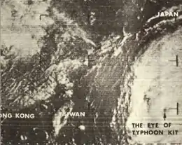
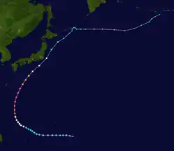
The incipient disturbance that became Super Typhoon Kit was first identified on June 20 near Chuuk State in the Federated States of Micronesia.[1] The JMA designated that system as a tropical depression that day as the system moved steadily westward.[2] The JTWC followed suit with this classification on June 22 following an investigation by reconnaissance. Early the next day, the depression acquired gale-force winds and was dubbed Tropical Storm Kit. Turning to the northwest, Kit developed a 35–55 km (20–35 mi) wide eye and reached typhoon status late on June 23.[1] Explosive intensification ensued late on June 24 into June 25; Kit's central pressure dropped 51 mbar (hPa; 1.51 inHg) in 18 hours from 965 mbar (hPa; 28.50 inHg) to 914 mbar (hPa; 26.99 inHg).[3] During this time, Kit's eye contracted to 13 to 17 km (8.1 to 10.6 mi).[1]

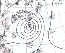
At 06:00 UTC on June 26, the JMA estimated Kit's pressure to have abruptly dropped to 880 mbar (hPa; 25.99 inHg),[2] which would rank it among the top ten most intense tropical cyclones on record.[4] Around this time, the JTWC estimated Kit to have attained peak winds of 315 km/h (195 mph);[3][5] however, these winds are likely an overestimate.[6] A later reconnaissance mission on June 26 reported a pressure of 912 mbar (hPa; 26.93 inHg), the lowest observed in relation to the typhoon.[1] Weakening ensued thereafter as the system accelerated to the north-northeast. Retaining typhoon strength, Kit brushed southeastern Honshu, Japan, on June 28, passing roughly 155 km (100 mi) east of Tokyo. The system subsequently weakened to a tropical storm and transitioned into an extratropical cyclone south of Hokkaido on June 29.[3] The National Oceanic and Atmospheric Administration reported the remnants of Kit to have dissipated the following day near northeastern Hokkaido.[7] However, the JMA states that the system turned eastward and accelerated over the north Pacific before losing its identity on July 3 near the International Dateline.[2]
Impact
| Typhoon | Season | Pressure | ||
|---|---|---|---|---|
| hPa | inHg | |||
| 1 | Tip | 1979 | 870 | 25.7 |
| 2 | June | 1975 | 875 | 25.8 |
| Nora | 1973 | |||
| 4 | Forrest | 1983 | 876[8] | 25.9 |
| 5 | Ida | 1958 | 877 | 25.9 |
| 6 | Rita | 1978 | 878 | 26.0 |
| 7 | Kit | 1966 | 880 | 26.0 |
| Vanessa | 1984 | |||
| 9 | Nancy | 1961 | 882 | 26.4 |
| 10 | Irma | 1971 | 884 | 26.1 |
| 11 | Nina | 1953 | 885 | 26.1 |
| Joan | 1959 | |||
| Megi | 2010 | |||
| Source:JMA Typhoon Best Track Analysis Information for the North Western Pacific Ocean.[9] | ||||
Although the center of Kit remained offshore, torrential rains and damaging winds wreaked havoc in eastern Japan.[10] An estimated 510 to 760 mm (20 to 30 in) of rain fell across the region, triggering deadly landslides and floods.[11] More than 128,000 homes were affected by flooding, of which 433 collapsed.[12] Large stretches of roadway crumbled or were blocked by landslides. Additionally, service along the 480 km (300 mi) Tokyo–Osaka rail line was disrupted for 12 hours.[10] "Hip-deep" waters also shut down Tokyo's subway system, stranding an estimated 2 million people.[13][14] Throughout the country, 64 people lost their lives while a further 19 were listed missing.[12] In the aftermath of the typhoon, 25 workers died from carbon monoxide poisoning from a portable generator while repairing a damaged irrigation tunnel near Utsunomiya.[15]
References
- "Chapter V: Individual Tropical Cyclones in 1966: Typhoon Kit". Annual Tropical Cyclone Report (PDF). Joint Typhoon Warning Center (Report). United States Navy. 1967. pp. 102–108. Retrieved March 12, 2015.
- "Typhoon 196604 (Kit) - Detailed Track Information". Japan Meteorological Agency. National Institute of Informatics. October 17, 1990. Retrieved March 12, 2015.
- Frank P. Rossi, ed. (May 1967). "Typhoons of the Western North Pacific, 1966". Mariners Weather Log. Washington, D.C. 11 (3): 75–82.
- "Typhoon List by Lowest Central Pressure: 870 hPa to 895 hPa". Japan Meteorological Agency. National Institute of Informatics. 2015. Retrieved March 12, 2015.
- "Super Typhoon 4 (Kit) Best Track" (.TXT). Joint Typhoon Warning Center. United States Navy. 1967. Retrieved March 12, 2015.
- John A. Knaff; Charles R. Sampson (2006). "Reanalysis of West Pacific Tropical Cyclone Maximum Intensity 1966–1987" (PDF). American Meteorological Society. Retrieved March 10, 2015.
- Patrick E. Hughes, ed. (November 1966). "Tracks of Centers of Cyclones at Sea Level, North Pacific: June 1966". Mariners Weather Log. Washington, D.C. 10 (6): 215.
- "World Tropical Cyclone Records". World Meteorological Organization. Arizona State University. Retrieved December 12, 2013.
- Japan Meteorological Agency. "RSMC Best Track Data (Text)" (TXT).
- "Typhoon Kit Takes 52 Lives". Mt. Vernon Register-News. Tokyo, Japan. Associated Press. June 29, 1966. p. 1. – via Newspapers.com (subscription required)
- "Typhoon Kit kills 38". The Oneonta Star. Tokyo, Japan. Associated Press. July 1, 1966. p. 13. – via Newspapers.com (subscription required)
- "台風196604号 (Kit) - 災害情報" (in Japanese). 国立情報学研究所. 2011. Retrieved March 10, 2015.
- "Typhoon Kit Dies Down After Killing Over 50". The Index-Journal. Tokyo, Japan. Associated Press. June 29, 1966. p. 32. – via Newspapers.com (subscription required)
- "Hip-Deep Water". The Daily Chronicle. Associated Press. July 1, 1966. p. 4. – via Newspapers.com (subscription required)
- "Death of 25 Blamed On Monoxide Exhaust". Albuquerque Journal. Utsunomiya, Japan. United Press International. July 10, 1966. p. 63. – via Newspapers.com (subscription required)
