Chuuk State
Chuuk State (also known as Truk) is one of the four states of the Federated States of Micronesia (FSM). The other states are Kosrae State, Pohnpei State, and Yap State. It consists of several island groups:
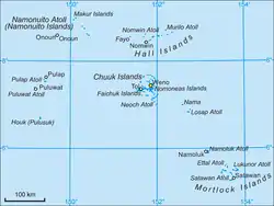
- Namoneas
- Faichuuk
- Hall Islands
- Namonuito Atoll (Magur Islands) (northwest)
- Pattiw (Western Islands)
- Mortlock Islands
Chuuk State | |
|---|---|
State | |
 Flag | |
 Map of Chuuk State | |
| Coordinates: 7°25′N 151°47′E | |
| Country | |
| Capital | Weno |
| Government | |
| • Governor | Johnson Elimo (since 2011) |
| Area | |
| • Total | 121.5 km2 (46.9 sq mi) |
| Population (2010) | |
| • Total | 48,654 |
| • Density | 400/km2 (1,000/sq mi) |
| ISO 3166 code | FM-TRK |
| Website | www |
Chuuk is the most populous state of the FSM with 50,000 inhabitants on 120 square kilometres (46 square miles). Chuuk Lagoon is where most people live. Weno Island in the lagoon functions as state capital and is FSM's biggest city. It is scheduled to possibly vote for independence in 2022.
History
Spanish Colonization
The first sighting recorded by Europeans was made by the Spanish navigator Alvaro de Saavedra on board the ship Florida during August or September 1528. They were later visited by the Spaniard Alonso de Arellano on January 15, 1565 on board the galleon patache San Lucas.
As part of the Caroline Islands, Truk was claimed by the Spanish Empire, which struggled to control the islands in the late 19th century. The Chuuk Lagoon was then inhabited by various tribes that participated in intermittent wars, as well as a small population of foreign merchants and missionaries, mostly linked to the Catholic Church. Spanish control over the islands was in part nominal. The Spanish stopped to raise a flag over Chuuk in 1886, and returned in 1895 as part of an attempt to assert control and negotiate peace between the warring tribes of Chuuk. No major Spanish settlement was established and tribal violence continued until the German colonial era.
German and Japanese rule
The Caroline Islands were sold to the German Empire in 1899, after Spain withdrew from the Pacific after the Spanish-American War in which it lost its main colony in Asia, the Philippines. Germany incorporated the territory into its domain in the German New Guinea.
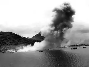
During World War I, the Japanese navy was tasked with pursuing and destroying the German East Asian squadron and protecting the shipping lanes of Allied trade in the Pacific and Indian Oceans. During the course of this operation, the Japanese Navy seized German possessions in the Mariana Islands, the Carolinas, the Marshall Islands and Palau groups by October 1914. Chuuk then became a possession of the Empire of Japan under the mandate of the League of Nations after the defeat of Germany in World War I.
United States rule
Chuuk was one of six districts of the Trust Territory of the Pacific Islands (TTPI) which were administered by the United States under charter from the United Nations from the end of the Second World War to the mid-1980s. The termination of U.S. administration of the Chuuk, Yap, Kosrae, Pohnpei, and Mariana Islands districts of the TTPI occurred on November 3, 1986.
Independence
The Federated States of Micronesia, including Chuuk, Yap, Kosrae, and Pohnpei, was established in 1979 and signed a Compact of Free Association with the U.S. (effective November 3, 1986).
On July 2, 2002, heavy rains from Tropical Storm Chataan caused more than thirty landslides that killed forty-seven people and injured dozens of others, in the state's deadliest weather disaster. The landslides occurred throughout the day, some within just minutes of each other.
As of recent times, Chuuk has been pushing harder for independence. An independence referendum was originally scheduled to coincide with federal elections on March 3, 2015, but was pushed back to March 5, 2019. The independence referendum was further pushed back to March 2022, with a date to be announced, while the constitutional legality of the proposed secession is determined.[1]
Geography
To the west is Yap State. To the east are Pohnpei State and Kosrae State is further east.
.jpg.webp)
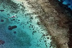
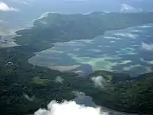
The main population center of Chuuk State is the Chuuk Lagoon, a large archipelago with mountainous islands surrounded by a string of islets on a barrier reef. The two major geographical and dialectic divisions of the Chuuk Lagoon are Faichuuk, the western islands, and Namoneas, the eastern islands.
Chuuk State also includes several more sparsely populated "outer island" groups, including the Mortlock Islands to the southeast, the Hall Islands (Pafeng) to the north, Namonuito Atoll to the northwest, and the Pattiw Region to west. The Pattiw Region is of particular interest in that it has some of the most traditional islands in the Pacific and is culturally related to outer islands of Yap. This group includes the islands of Pollap, Tamatam, Poluwat, and Houk. Today you can still find traditional master navigators—Poluwat and Pollap are considered to have some of the best navigators and ocean-going outrigger canoes in the Pacific. In the islands of the Pattiw Region, and some of the Islands of Yap, you will still find today the last two remaining schools of navigation, Weriyeng and Faaluush. Visiting the Pattiw Region in the west, however, is difficult due to the lack of reliable transportation. Houk probably has the most accessible airstrip in the Pattiw Region, with planes landing every one or two weeks.
The state shares its longitude with Sydney, Australia, namely the eastern portion of the city including the CBD.
Climate
| Climate data for Weno, Chuuk | |||||||||||||
|---|---|---|---|---|---|---|---|---|---|---|---|---|---|
| Month | Jan | Feb | Mar | Apr | May | Jun | Jul | Aug | Sep | Oct | Nov | Dec | Year |
| Record high °C (°F) | 33 (91) |
32 (90) |
32 (90) |
33 (92) |
33 (91) |
33 (92) |
33 (92) |
33 (92) |
34 (93) |
33 (92) |
33 (91) |
33 (91) |
34 (93) |
| Average high °C (°F) | 29.9 (85.8) |
29.9 (85.8) |
30.2 (86.4) |
30.4 (86.7) |
30.7 (87.3) |
30.7 (87.3) |
30.6 (87.1) |
30.7 (87.3) |
30.7 (87.3) |
30.7 (87.3) |
30.7 (87.3) |
30.2 (86.4) |
30.4 (86.7) |
| Daily mean °C (°F) | 27.4 (81.3) |
27.5 (81.5) |
27.6 (81.7) |
27.7 (81.9) |
27.8 (82.0) |
27.7 (81.9) |
27.4 (81.3) |
27.4 (81.3) |
27.5 (81.5) |
27.6 (81.7) |
27.7 (81.9) |
27.6 (81.7) |
27.6 (81.7) |
| Average low °C (°F) | 24.9 (76.8) |
25.0 (77.0) |
25.1 (77.2) |
25.0 (77.0) |
24.9 (76.8) |
24.6 (76.3) |
24.2 (75.6) |
24.2 (75.6) |
24.2 (75.6) |
24.3 (75.7) |
24.6 (76.3) |
25.0 (77.0) |
24.7 (76.5) |
| Record low °C (°F) | 21 (69) |
21 (70) |
22 (71) |
22 (71) |
21 (70) |
21 (70) |
21 (70) |
21 (70) |
20 (68) |
19 (66) |
21 (70) |
21 (70) |
19 (66) |
| Average precipitation mm (inches) | 228 (8.98) |
163 (6.42) |
230 (9.05) |
291 (11.46) |
354 (13.94) |
301 (11.84) |
365 (14.37) |
350 (13.77) |
307 (12.07) |
361 (14.23) |
282 (11.10) |
293 (11.55) |
3,525 (138.78) |
| Average precipitation days (≥ 1.0 mm) | 14.8 | 12.2 | 14.9 | 16.2 | 21.2 | 20.3 | 20.8 | 21.0 | 18.6 | 20.0 | 20.0 | 18.8 | 218.8 |
| Average relative humidity (%) | 78.7 | 77.7 | 78.7 | 81.0 | 82.6 | 82.9 | 83.9 | 83.2 | 83.0 | 83.1 | 81.9 | 80.8 | 81.6 |
| Mean monthly sunshine hours | 195.3 | 197.8 | 217.0 | 195.0 | 192.2 | 180.0 | 195.3 | 195.3 | 177.0 | 161.2 | 162.0 | 167.4 | 2,235.5 |
| Source 1: Hong Kong Observatory (sun 1961–1990)[2] | |||||||||||||
| Source 2: NOAA [3] | |||||||||||||
Demographics
Chuuk is the most populous of the FSM's states. At the census held on 1 April 2000, it had 53,595 inhabitants, compared with 34,486 for Pohnpei, 11,241 for Yap and 7,686 for Kosrae; at the census held on 4 April 2010, it had 48,654 inhabitants, compared with 36,196 for Pohnpei, 11,377 for Yap and 6,616 for Kosrae.[4]
Culture
Jesuit mission at Weno
The New York Province of the Society of Jesus (the Jesuits) maintains a mission school on the island of Weno in Chuuk. Xavier High School is housed at the former Japanese communications center. It is a coeducational institution, drawing students from all the island groups of the Federated States of Micronesia, as well as Palau and the Marshall Islands. Teachers are both Jesuit and lay and come from Micronesia, the U.S., Indonesia, Japan, and Australia.
Spirit possession
Although Chuuk is an overwhelmingly Christian society, traditional beliefs in spirit possession by the dead still exist. Allegedly, these spirits overwhelmingly possess women, and spirit possession is usually brought on by family conflicts. The spirits, speaking through the women, typically admonish family members to treat each other better.[5]
Cultural references
There are some references on the Chuukese language, treating guests, and on beliefs in the sci-fi book "Reefsong" from Carol Severance.
Municipalities
Of the 40 municipalities of the state, 16 fall within the Chuuk Lagoon and 24 in the Outer Islands. In the table below, each is followed by its population at the Census held on 1 April 2000.[4]
Faichuuk (Shichiyo) Islands:
Toleisom (District#7):
- Tol
PPO (District#6):
- Paata
- Polle
- Onei
Nomwisofo Group/District#5:
- Eot
- Fanapanges
- Romanum
- Udot
Nomoneas (Shiki) Islands
Northern Nomoneas (population) Islands:
- Fono (397)
- Piis-Paneu (523)
- Weno (Moen) (13,802)
Southern Nomoneas (Shiki) Islands:
Mortlock Islands
Lower Mortlock Islands (Nomoi Islands):
- Etal (267)
- Lukunor (927)
- Oneop (west islet of Lukunor Atoll) (505)
- Satawan (955)
- Kuttu (west islet of Satawan Atoll)
- Moch (north islet of Satawan Atoll)
- Ta (southeast islet of Satawan Atoll)
Upper Mortlock Islands (Eastern Islands):
- Nama (995)
- Losap (448)
- Pis-Losap (islet of Losap Atoll)
- Namoluk (407)
Northwest Outer Islands
Hall Islands (north):
- Fananu (eastern islets of Nomwin Atoll)
- Murilo
- Nomwin (including uninhabited Fayu Atoll)
- Ruo (southeast islet of Murilo Atoll)
Namonuito Atoll (Magur Islands) (northwest):
Pattiw Islands (Western Islands):
- Pulap (north islet of Pollap Atoll)
- Poluwat (Puluwat)
- Pulusuk (also known as Houk Island)
- Tamatam (south islet of Pollap Atoll, with Fanadik islet in the center)
Education
Chuuk State Department of Education operates public schools.
Public high schools:[6]
- Chuuk High School - Weno
- Faichuk High School
- Moch High School
- Mortlock High School
- Southern Namoneas High School (SNHS)[7]
- Weno High School[7]
Private secondary schools:[7]
- Berea Christian High School - Weno
- Saramen Chuuk Academy
- Xavier High School - Weno
- Mizpah Christian High School
- Seventh Day Adventist Mission School\[6]
Private primary schools:[6]
- Pentecostal Light House Academy
- Saint Cecilia School
- Seventh Day Adventist Mission School
See also
- Habele, a South Carolina-based charity providing private economic educational assistance in Chuuk.
References
- Graue, Catherine (5 March 2019). "Chuuk independence vote was to be today but citizens now have another year". ABC Radio Australia. Retrieved 12 August 2019.
- "Climatological Information for Truk, Pacific Islands, United States". Hong Kong Observatory. Archived from the original on March 4, 2016. Retrieved December 13, 2012.
- "TRUK ISLAND/CAROLINE ISLANDS PI Climate Normals 1961–1990". National Oceanic and Atmospheric Administration. Retrieved December 13, 2012.
- Office of Statistics, Budget and Economic Management, Overseas Development Assistance and Compact Management.
- Hezel, Francis X. 1993 Spirit Possession in Chuuk: Socio-Cultural Interpretation. Micronesian Counselor 11
- "School location." Chuuk State Department of Education. Retrieved on February 28, 2018.
- "Higher Education in the Federated States of Micronesia Archived 2017-10-14 at the Wayback Machine." Embassy of the Federated States of Micronesia Washington DC. Retrieved on February 23, 2018.
External links
| Wikivoyage has a travel guide for Chuuk. |
| Wikimedia Commons has media related to Chuuk. |