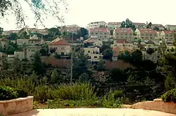
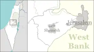
Tzur Hadassah
Tzur Hadassah (Hebrew: צוּר הֲדַסָּה, lit. Rock of Hadassah) is a town located in the Jerusalem Corridor, located 12 kilometres (7.5 mi) southwest of Jerusalem, at an altitude of 755 meters above sea level, located on Route 375 west of Betar Ilit, about one kilometer west of the Green Line, just adjacent to the Palestinian village of Wadi Fukin. According to the Central Bureau of Statistics, Tzur Hadassah is the largest settlement in Israel that does not have a local authority status. It falls under the jurisdiction of Mateh Yehuda Regional Council. In 2019 it had a population of 11,120.[1] In 2016, plans for expansion were approved, which would add 15,000 new residents within 5 years.[2]
Tzur Hadassah
צוּר הֲדַסָּה تسور هداسا | |
|---|---|
 | |
 Tzur Hadassah | |
| Coordinates: 31°43′9″N 35°5′51″E | |
| Country | Israel |
| District | Jerusalem |
| Council | Mateh Yehuda |
| Founded | 1960 |
| Population (2019)[1] | 11,120 |
History
Tzur Hadassah was established in 1956 as a regional centre for nearby moshavim such as (Bar Giora, Mata, Mevo Beitar and Nes Harim) on land that had belonged to the depopulated Palestinian village of Ras Abu 'Ammar.[3] It was named for the Hadassah organization.
The town has four neighborhoods: Old Tzur Hadassah (Shehunat HaMeah); New Tzur Hadassah (Shehunat HaEmek); Har Sansan (Sansan Mt.); And Har Kitron (Kitron Mt.) which forms the second half of the horseshoe topography of Tzur Hadassah.[4]
The Harei Yehuda riding stable is located in Tzur Hadassah, at the edge of the Sansan nature reserve. It was established in 1991 in the old part of Tzur Hadassah and moved to new facilities in 2004.[5] The Israel National Trail, marked with orange, blue, and white stripes, reaches Tzur Hadassah on its way westward.[6] In 2014, construction workers discovered a large stalactite cave near Tzur Hadassah.[7]
See also
Gallery
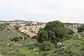 Tzur Hadassah as seen from Khirbet Jurish
 Tzur Hadassa (from Kh. Jurish)
References
- "Population in the Localities 2019" (XLS). Israel Central Bureau of Statistics. Retrieved 16 August 2020.
- "אוכלוסיית צור הדסה תוכפל ב־5 שנים בזכות שכונה חדשה". ynet (in Hebrew). 2016-04-14. Retrieved 2020-04-04.
- Khalidi, Walid (1992). All That Remains: The Palestinian Villages Occupied and Depopulated by Israel in 1948. Washington D.C.: Institute for Palestine Studies. p. 312. ISBN 0-88728-224-5.
- "Communities & Housing in Israel".
- "Harei Yehuda - Stable Tsur Hadassah". www.hyr.co.il.
- "ERETZ Magazine". www.eretz.com.
- Ben-Gedalyahu, Tzvi. "Huge Stalactite Cave Discovered Near Gush Etzion".
