Zanoah
Zanoah (Hebrew: זָנוֹחַ) is a moshav in central Israel. Located adjacent to Beit Shemesh, it falls under the jurisdiction of Mateh Yehuda Regional Council. In 2019 it had a population of 524.
Zanoah
זנוח زنواح | |
|---|---|
 | |
 Zanoah | |
| Coordinates: 31°43′56″N 34°59′57″E | |
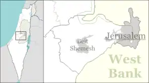
| Country | Israel |
| District | Jerusalem |
| Council | Mateh Yehuda |
| Affiliation | Poalei Agudat Yisrael |
| Founded | 1950 |
| Founded by | Yemenite Jews |
| Population (2019)[1] | 524 |
History
The village was established in 1950 by immigrants from Yemen, and was initially named Dayraban Gimel after the nearby depopulated Palestinian village of Dayr Aban.[2] In the following years the founders left and were replaced by immigrants from Morocco.
Education
The Beit Shemesh Yeshiva is located in Zanoah. Most of the students are from Ramat Beit Shemesh Alef. Aside from Talmud study, the curriculum includes English language and mathematics, and unlike many such institutions in Israel today, students study for the Bagrut matriculation exams.[3] From 2004 to 2015, when it closed, Zanoah was also the home of Yeshivat Yesodei HaTorah, which offered a gap year program for international English-speaking students.
Geography and archaeology
Nahal Zanoah is a stream that runs north and drains into Nahal Sorek.[4]
The ruins (Khurbet Zanuʻ) on a high hill south of the moshav are thought to be the ancient village of Zanoah mentioned in Egyptian letters, later part of the tribe of Judah (Joshua 15:34), and in the "Second Temple period ... reinhabited,"[5][6] as recorded in the Bible (Nehemiah 3:13).[Note 1] During the 1st-century CE, the village was known by the name Zenoha. The site reeks with antiquity, with the signs of an old settlement everywhere. The site is extensive, with razed structures that once stood as walls and houses. Shards of broken pottery are strewn on the grounds everywhere, with several open-mouthed cisterns and antres.
An archaeological survey of the site was conducted in 2008 by Pablo Betzer on behalf of the Israel Antiquities Authority (IAA).[9] According to the Mishnah (Munich MS., Menahot 83b),[10] the finest of the wheat used to grow in the valley adjacent to Zanoah, from whence it was taken for the offering of the Omer in the Temple. Although listed in Joshua 15:34 as being a city in the plain, it is actually partly in the hill country, partly in the plain.
C.R. Conder and H.H. Kitchener described the ruins of Khurbet Zanûa, visited by them in 1881.[11]
Gallery of the nearby Zanoah Ruin (Kh. Zanua)
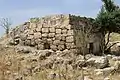 Zanoah ruin, old house
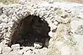 Arched doorway, Kh. Zanua (Old Zanoah)
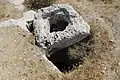 Voussoir stone in Zanoah
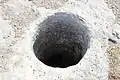 Gaping hole in cistern at the Zanoah Ruin
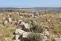 General view of ruins at the Zanoah ruin (Khurbet Zanua)
.jpg.webp) Open cistern at the Zanoah ruin
Open cistern at the Zanoah ruin Open pit in the Old Zanoah
 Stone covering of cistern
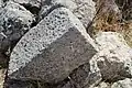 Razed blocks of hewn stones at Zanoah
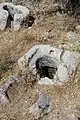 Stone relics at ruin of Zanoah
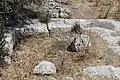 Rock-carved foundation of house in the Zanoah ruin
 General view of ruins at Khurbet Zanua (Zanoah)
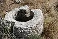 Stone relic of Zanoah
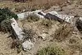 House foundation at Kh. Zanoah
Notes
- There were two towns bearing the same name; one in the Shefelah of Judah, called זנוח (Zanoah),[7] and the other in the mountainous district of Judah, also called זנוח (Zanoah)[8]
References
- "Population in the Localities 2019" (XLS). Israel Central Bureau of Statistics. Retrieved 16 August 2020.
- Yalqut Teiman, Yosef Tobi and Shalom Seri (editors), Tel-Aviv 2000, p. 82, s.v. זנוח (Hebrew) ISBN 965-7121-03-5
- Ettinger, Yair (September 8, 2019). "Black and White in Color". Haaretz. Retrieved May 19, 2019.
- Rosenfelder, Reuven (December 22, 2005). "Follow the Red Rock Road". The Jerusalem Post. Retrieved May 19, 2019.
- Robinson, Edward (1856). Biblical Researches in Palestine. II. Boston: Crocker and Brewster. p. 16 (note 4).
- Carta's Official Guide to Israel and Complete Gazetteer to all Sites in the Holy Land. (3rd edition 1993) Jerusalem, Carta, p.481, ISBN 965-220-186-3
- Joshua 15:34
- Joshua 15:56
- Israel Antiquities Authority, Excavators and Excavations Permit for Year 2008, Survey Permit # S-44
- Danby, H. ed., (1933), Mishnah Menahot 8:1 (p. 502); Jastrow, M., ed. (2006), Dictionary of the Targumim, the Talmud Babli and Yerushalmi, and the Midrashic Literature, Peabody, Mass.: Hendrickson Publishers, p. 406, OCLC 614562238, s.v. זנוחא. Both editors have used זנוחה, as found in the Munich MS., as the principalis lectionis, and acknowledging that a scribal error befell the copyist of the Tosefta [Zuckermandel edition] (Menahot 9:2), where he wrote זו לחה, instead of וזנוחה.
- Conder, C.R.; Kitchener, H.H. (1883). Survey of Western Palestine – Memoirs of the Topography, Orography, Hydrography, and Archaeology. III: Judea. London: The Committee of the Palestine Exploration Fund. p. 128-129.
External links
- Zanoah in Antiquity Archaeological Survey of Israel
| Wikimedia Commons has media related to Zanoah. |
