Kumasi
Kumasi (historically spelled Comassie or Coomassie and usually spelled Kumase in Twi)[3] is a city in Ashanti Region, and is among the largest Metropolitan areas in Ghana. Kumasi is near Lake Bosomtwe, in a rain forest region, and is the commercial, industrial and cultural capital of the historical Ashanti Empire. Kumasi is approximately 500 kilometres (300 mi) north of the Equator and 200 kilometres (100 mi) north of the Gulf of Guinea. Kumasi is alternatively known as "The Garden City"[4] because of its many beautiful species of flowers and plants in the past. It is also called Oseikrom (Osei Tutu's town). Kumasi is the second largest city in Ghana, after the capital, Accra.[5] The Central Business District of Kumasi includes areas such as Adum, Bantama and Bompata (popularly called Roman Hill) has a concentration of banks, department stalls, and hotels. Economic activities in Kumasi include financial and commercial sectors, pottery, clothing and textiles. There is a huge timber processing community in Kumasi serving the needs of people in Ghana. Bantama High Street and Prempeh II Street in Bantama and Adum, respectively, are business and night life hubs in Kumasi.
Kumasi | |
|---|---|
_location_map.png.webp) Kumasi  Kumasi  Kumasi | |
| Coordinates: 6°40′N 1°37′W | |
| Country | |
| Administrative division | |
| Municipality | Kumasi Metropolitan |
| Founded | 1680 |
| Government | |
| • Type | Mayor–council |
| • Mayor | Osei Assibey Antwi |
| Area | |
| • Total | 254 km2 (98 sq mi) |
| Elevation | 250 m (820 ft) |
| Population (2020 est.) | |
| • Total | 3,348,000[2] |
| Time zone | UTC |
| Postal codes | AK000-AK911 |
| Area code(s) | 032 |
| Website | kma.gov.gh |
History
Origins
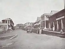
_p344_PLATE_9_-_COOMASSIE%252C_PART_OF_ADAM_STREET.jpg.webp)
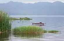
There is evidence that the area around Kumasi has been kept cleared since the Neolithic age and that the first human settlement was at Lake Bosomtwe.
Etymology
The name derives from the Twi language, meaning "Under the Kum tree." The word "ase" or "asi" means "under, down, or below" and is used in many place names in Ghana, such as Obuasi, Daboase, and Kenyase.
Around the end of the 17th century, the Asante Kingdom chief fetish Priest Anokye Komfuo planted three "KUM" trees at different places: one at Kwaaman ruled by the Nananom Ayokofuo, a second one at Apemso-Bankofo ruled by Nananom Aduanafuo, and a third at a village near Fomena and Amoafo called Oboani, which was ruled by Nananom Ɛkoɔnafuo. He wanted to see which of these would become a great city for the kingdom, as he was directed by the oracles. The Kum tree at Kwaaman flourished and became a very big tree under which the King and his people often sat, and so Kwaaman became Kum-ase meaning under Kum.
The tree at Oboani was, however, very tiny and for no apparent reason was relatively short. According to oral tradition this small tree however produced a couple of other trees which were all small in size. The name of the village was changed to Kuma meaning small Kum.
The Kum tree at Apemso-Bankofo did not grow at all. After some few weeks the leaves got rotten and the tree fell down. So it was said that the Kum tree was dead and the village became Kum-awu and this later changed to become Kumawu.[6]
Asanteman
The city rose to prominence in 1695 when it became capital of the Ashanti Confederacy due to the activities of its ruler Osei Tutu.[7] The ruler of Kumasi, known as the Asantehene, also served as ruler of the Confederacy, with their 1701 victory over Denkyira the Asante confederacy became the primary state among the Ashantis.[8] Parts of the city, including the then royal residence, were destroyed by British troops in the Third Anglo-Ashanti War of 1874.[9]
Lady Mary Alice Hodgson, the first English lady to visit Ashanti, wrote "The Siege of Kumasi" an account of the siege of the fort by the nationals of Ashanti and of the subsequent march to the coast.[10] (She was the daughter of Hon. W. A. G. Young, C.M.G., former governor of the Gold Coast, and the wife of Sir Frederick Mitchell Hodgson, K.C.M.G., the governor of the Gold Coast in 1900.[10])
In 1926, following the return of the Ashanti King Prempeh I, after a 30-year exile, Kumasi was restored as the ceremonial control over the Ashanti sub-states .The full role of king was restored by the colonial administration in 1935. The city holds an important place in the history of the Ashanti people, as legend claims that it was here Okomfo Anokye received the golden stool, an embodiment of the soul of the Ashanti nation Ashanti. Yaa Asantewaa, also a very renowned Ashanti warrior and leader, was taken to Seychelles Island and never returned.
Geography
The city features a tropical wet and dry climate, with relatively constant temperatures throughout the course of the year. Kumasi averages around 1400 mm (55") of rain per year.
The city almost features two rainy seasons: a longer season from March through July and a shorter rainy season from September to November.
The months of February through to November is one long wet season, with a relative lull in precipitation in August. Similar to the rest of West Africa, Kumasi experiences the harmattan during the "low sun" months. Lasting from December to February, the harmattan is the primary source of the city's dry season.
Climate
| Climate data for Kumasi | |||||||||||||
|---|---|---|---|---|---|---|---|---|---|---|---|---|---|
| Month | Jan | Feb | Mar | Apr | May | Jun | Jul | Aug | Sep | Oct | Nov | Dec | Year |
| Record high °C (°F) | 36.7 (98.1) |
37.2 (99.0) |
37.8 (100.0) |
36.1 (97.0) |
35.0 (95.0) |
32.8 (91.0) |
31.1 (88.0) |
30.0 (86.0) |
31.7 (89.1) |
32.2 (90.0) |
32.8 (91.0) |
33.3 (91.9) |
37.8 (100.0) |
| Average high °C (°F) | 31.9 (89.4) |
33.5 (92.3) |
32.9 (91.2) |
32.3 (90.1) |
31.3 (88.3) |
29.5 (85.1) |
28.0 (82.4) |
27.7 (81.9) |
28.7 (83.7) |
30.1 (86.2) |
31.2 (88.2) |
30.7 (87.3) |
30.7 (87.3) |
| Average low °C (°F) | 20.4 (68.7) |
22.0 (71.6) |
22.3 (72.1) |
22.4 (72.3) |
22.2 (72.0) |
21.6 (70.9) |
21.2 (70.2) |
21.0 (69.8) |
21.1 (70.0) |
21.5 (70.7) |
21.7 (71.1) |
20.8 (69.4) |
21.5 (70.7) |
| Record low °C (°F) | 11.7 (53.1) |
13.3 (55.9) |
17.8 (64.0) |
19.4 (66.9) |
18.9 (66.0) |
18.9 (66.0) |
17.2 (63.0) |
16.1 (61.0) |
18.3 (64.9) |
15.6 (60.1) |
13.9 (57.0) |
10.6 (51.1) |
10.6 (51.1) |
| Average precipitation mm (inches) | 15.1 (0.59) |
66.3 (2.61) |
137.0 (5.39) |
129.3 (5.09) |
174.4 (6.87) |
214.3 (8.44) |
157.5 (6.20) |
89.9 (3.54) |
165.2 (6.50) |
153.3 (6.04) |
74.3 (2.93) |
25.8 (1.02) |
1,402.4 (55.21) |
| Average precipitation days | 2 | 5 | 9 | 10 | 14 | 17 | 14 | 12 | 17 | 17 | 8 | 3 | 128 |
| Mean monthly sunshine hours | 186.6 | 187.2 | 205.4 | 204.0 | 204.7 | 146.3 | 101.2 | 77.0 | 106.2 | 161.4 | 193.8 | 178.0 | 1,951.8 |
| Source 1: World Meteorological Organization,[11] Sistema de Clasificación Bioclimática Mundial (extremes)[12] | |||||||||||||
| Source 2: Deutscher Wetterdienst (sun, 1961–1990)[13][lower-alpha 1] | |||||||||||||
Culture
Features of the city include Fort Kumasi (built by in 1896 to replace an Asante fort and now a museum) and the Kumasi Hat Museum.
Royal Asante attractions include the Kumasi National Cultural Centre (including the Prempeh II Jubilee Museum with Asante regalia with a reproduction of the golden stool), the Okomfo Anokye Sword, the Asantehene's Palace (built in 1972), and the Manhyia Palace, dating from 1925, now a museum.
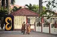
Places of worship
.jpg.webp)
Among the places of worship, which are predominantly Christian churches and temples, are: Methodist Church, Presbyterian Church of Ghana, Church of the Province of West Africa, (Anglican Communion), Seventh-day Adventist Church Evangelical Presbyterian Church, Ghana (World Communion of Reformed Churches), Christ Apostolic Church International(which was the first Pentecostal church in Ghana) Ghana Baptist Convention (Baptist World Alliance), Lighthouse Chapel International, Church of Pentecost, Assemblies of God, and Catholic Church Archdiocese of Kumasi (Catholic Church).[14] There are also Muslim mosques which include: Kumasi Central mosque, Ahmadiyya mosque, Alhaj mosque, Kaase-Nhyiaeso mosque and Rahman mosque.
Economy
The main occupations in Kumasi are professional such as services and manufacturing.
Mining and exports
Manufacturing
Kumasi has 50% of the timber industry of Ghana, and the Kaasi Industrial Area plays an important role in the local industry. The Guinness Ghana Breweries is based in Kumasi.
Energy
Solar panels are prevalent in Kumasi and Ashanti. Solar energy technology is a major energy source and contributor of electricity generation in Ashanti.
Commerce
Much of the shopping and trading activity in the city takes place at Kumasi's shopping streets, in and around Kejetia Market and Adum. These two areas – Kejetia and Adum – have a common boundary. There is also heavy economic activities at Bantama and Asafo. Asafo in particular is the printing hub of Kumasi. Most of the printing done in Kumasi and Ashanti Region as a whole is done at Asafo.
Education
Primary school
There are both government-assisted primary schools in Kumasi and also private primary schools in Kumasi which educate boys and girls between the ages from 6 to 15.
Secondary education
The elite all-boys senior high schools in Kumasi are Prempeh College and Opoku Ware School. And the elite all-girls schools in Kumasi are Yaa Asantewaa Girls Senior High School and St. Louis Senior High School. There are so many public and private Senior High schools in Kumasi.
Tertiary institutions
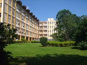
The Kwame Nkrumah University of Science and Technology, Kumasi (formerly the Kumasi College of Technology) is the biggest university in the Ashanti Region and the second biggest in Ghana after the University of Ghana. Former Secretary-General of the United Nations, Kofi Annan attended this institution. A number of other public and private universities and tertiary institutions have since been founded in Kumasi, some of which are listed below.
| Institution | Location | Private/ Public | Affiliation | |
|---|---|---|---|---|
| Kwame Nkrumah University of Science and Technology | Bomso to Anwomaso | Public | ||
| Wesley College of Education | Tafo | Public | ||
| St Louis College of Education | Mmrom | Public | ||
| Garden City University College | Kenyase | Private | Kwame Nkrumah University of Science and Technology | |
| Christian Service University College | Santasi | Private | University of Ghana | |
| Ghana Baptist University College | Amakom | Private | University of Cape Coast | |
| Valley View University (Kumasi Campus) | Oduom | Private | ||
| University College of Management Studies (Kumasi Campus) | Ayeduase | Private | ||
| Christ Apostolic University College | Kwadaso | Private | ||
| Kessben University | Lake Road | Private | Akenten Appiah-Menka University of Skills Training and Entrepreneurial Development (est. 2020)
formerly the University of Education, Winneba (Kumasi Campus)]] Tanoso |
Transportation
Air
Kumasi is served by the Kumasi Airport. As of May 2020 two airlines offered regularly scheduled flights to Accra. Airlines servicing the airport included Africa World Airlines and Passion Air. The airport has undergone construction to allow for night operations.[15]
Bus and taxicab
Public transport in the city is provided by transit buses, a mix of privately owned mini-buses known as tro tros, taxicabs and buses. Tro tros are usually converted mini-buses that run regular, well-known routes. Some taxis also run regular routes, which cost more but provide for a more comfortable ride.
In 2002, the city introduced the metro bus services, a rapid transit system for public road transport in Kumasi (MetroMass).[16] This was to reduce congestion on roads and to make a larger and more organised bus routine system in the city.[17]
In 2017, Uber introduced services in Kumasi, a year after a successful introduction in Accra. Yenko Taxi offers similar service.
Rail
Kumasi is served by the railway lines to Sekondi-Takoradi and Accra. The train service has been suspended for several years because of damaged track, bridges and locomotives. Currently, no train is running from and to Kumasi due to the collapse of the railway corporation some years back. A $6 billion project to upgrade the railways was due to get underway in 2011.[18]
Port
As of 2011, construction of the Boankra Inland Port, about 25 kilometres (16 mi) away, has come to a halt.[19]
Sports
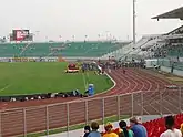
The local football (soccer) team, the Kumasi Asante Kotoko has won several national and continental trophies and awards, and serves as a rival to the Accra-based Hearts of Oak. Their Kumasi Sports Stadium, also known as Baba Yara Stadium, was built in 1959, renovated in 1978, and again in 2007 with a seating capacity of 40,000.[20] It is also the home of King Faisal Football Club, a premier division side.
There is the Royal Golf Club which has the Asantehene as president. Former Leeds United and Ghana national football team footballer Tony Yeboah was born in Kumasi. Professional wrestler Kofi Kingston was born in Kumasi.
Healthcare
Kumasi has the Komfo Anokye Teaching Hospital to support medical training at the university, the West End Hospital, several other private hospitals, public clinics and hospitals. Recommended private medical facilities include Kumasi Rabito Clinic located at Ahondwo-Daban Kumasi behind the Unity Oil Filling Station.There is also the KNUST hospital that serves people in the University and surrounding communities.
Recreational parks and gardens
Kumasi has four recreational parks which are opened to the public. The list of recreational parks are Abbey's Park which is located some few meters away from Kejetia, Jackson's Park, Hero's Park located on the same premises as the Baba Yara Sports Stadium, and finally the Rattray Park which was commissioned in 2015.
International relations
Twin towns and sister cities
Kumasi is twinned with:
| Country | City | County / district / region / state | Date | |||
|---|---|---|---|---|---|---|
| Ivory Coast | Abidjan | Lagunes | 2004 | |||
| Treichville | ||||||
| US | Atlanta | Georgia | 2010 | |||
| Netherlands | Almere | Flevoland | 2001 | |||
| US | Charlotte | North Carolina | 1996 | |||
| US | Columbus | Ohio | 2008 | |||
| Canada | Kitchener | Ontario | 2010 | |||
| US | Newark | New Jersey | 1999 | |||
| South Africa | Gauteng | 2010 | ||||
| US | Winston-Salem | North Carolina | 2001 | |||
| UK | Methilhill | Scotland | 2017 | |||
Notes
- Station ID for Kumasi is 65442 Use this station ID to locate the sunshine duration
External links
| Wikimedia Commons has media related to Kumasi. |
| Wikivoyage has a travel guide for Kumasi. |
References
- "Demographic Characteristics". Ghanadistricts.com. Archived from the original on 3 May 2011. Retrieved 16 August 2010.
- "World Population Review". Retrieved 31 August 2020.
- "COOMASSIE AND MAGDALA: The Story of Two British Campaigns in Africa". Naval & Military Press. Retrieved 28 October 2016.
- 122108447901948 (31 July 2013). "Kumasi: The Garden City without gardens?". Graphic Online. Retrieved 11 January 2020.CS1 maint: numeric names: authors list (link)
- "The grasscutter shows why it is hard to stop bushmeat hunting". The Economist. 31 August 2017.
- The Story of Two British Campaigns in Africa - Naval & Military Press|publisher=|accessdate=28 October 2016}}
- Britannica, Kumasi, britannica.com, USA, accessed on June 30, 2019
- McCaskie, T. C. "Denkyira in the Making of Asante" in The Journal of African History vol. 48 (2007) no. 1, p. 1
- David Owusu-Ansah, Historical Dictionary of Ghana, Rowman & Littlefield, USA, 2014, p. xliii
- Morgan, Henry James, ed. (1903). Types of Canadian Women and of Women who are or have been Connected with Canada. Toronto: Williams Briggs. p. 160.
- "World Weather Information Service–Kumasi". World Meteorological Organization. Retrieved 14 June 2015.
- "Ghana–Kumasi". Centro de Investigaciones Fitosociológicas. Retrieved 14 June 2015.
- "Station 65442: Kumasi". Global station data 1961–1990—Sunshine Duration. Deutscher Wetterdienst. Archived from the original on 17 October 2017. Retrieved 14 June 2015.
- J. Gordon Melton, Martin Baumann, ‘‘Religions of the World: A Comprehensive Encyclopedia of Beliefs and Practices’’, ABC-CLIO, USA, 2010, p. 1209-1211
- "President Respects All Tribes – NDC". Ghana Broadcasting Corporation. 9 May 2014. Retrieved 9 May 2014.
- "Ashanti Region". Metro Mass Transit Ltd. Retrieved 1 December 2011.
- "Bus Rapid Transit System". Metro Mass Transit Ltd. Retrieved 1 December 2011.
- "Ghana, China signs railway contract". Ghana News Link. 30 November 2010. Retrieved 1 December 2011.
- "Baonkra Inland Port Project, stuck?". Kapital News. Kapital Radio 97.1 FM. 7 February 2011. Archived from the original on 18 January 2012. Retrieved 1 December 2011.
- Kumasi Sports Stadium Ready Archived 28 September 2007 at the Wayback Machine. TheStatesManOnline.com.


| Authority control |
|---|