Wunsiedel (district)
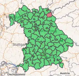
Wunsiedel (German: Landkreis Wunsiedel i. Fichtelgebirge) is a Landkreis (district) in the northeastern part of Bavaria, Germany. Neighbouring districts are (from the south clockwise) Tirschenreuth, Bayreuth, Hof, and to the east the Czech Karlovy Vary Region.
Wunsiedel | |
|---|---|
| |
| Country | Germany |
| State | Bavaria |
| Adm. region | Upper Franconia |
| Capital | Wunsiedel |
| Area | |
| • Total | 606.40 km2 (234.13 sq mi) |
| Population (31 December 2019)[1] | |
| • Total | 72,655 |
| • Density | 120/km2 (310/sq mi) |
| Time zone | UTC+01:00 (CET) |
| • Summer (DST) | UTC+02:00 (CEST) |
| Vehicle registration | WUN |
| Website | landkreis-wunsiedel.de |
Geography
The district is located in the mountains of the Fichtelgebirge, with the highest elevation the 1051 m high Schneeberg. The river Ohře (German: Eger) originates in the district.
History
In the Bavarian communal reforms of 1972 the district was merged with the previously district-free cities Marktredwitz and Selb, as well as parts of the dissolved district of Rehau.
Coat of arms
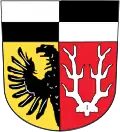 |
The coat of arms shows an eagle in the bottom left as the symbol of the city Marktredwitz, and a deer antler to the right as the symbol of the city Selb. In the top are the black-and-white symbol of the Zollern dynasty. The coat of arms was granted in 1974. |
Towns and municipalities
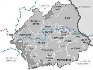
Towns and municipalities in Landkreis Wunsiedel
| Towns | Municipalities |
|---|---|
|
¹ administrated inside a Verwaltungsgemeinschaft | |
References
- "Tabellenblatt "Daten 2", Statistischer Bericht A1200C 202041 Einwohnerzahlen der Gemeinden, Kreise und Regierungsbezirke". Bayerisches Landesamt für Statistik und Datenverarbeitung (in German). July 2020.
External links
| Wikimedia Commons has media related to Landkreis Wunsiedel im Fichtelgebirge. |
- Official website (German)
Towns and municipalities in Wunsiedel (district) | ||
|---|---|---|
| Authority control |
|---|
This article is issued from Wikipedia. The text is licensed under Creative Commons - Attribution - Sharealike. Additional terms may apply for the media files.