Upper Hutt
Upper Hutt (Māori: Orongomai)[2] is a city in the Wellington Region of the North Island of New Zealand, and one of the four cities that constitute the Wellington metropolitan area.
Upper Hutt
Orongomai (Māori) | |
|---|---|
| Upper Hutt City | |
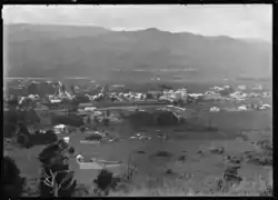 View of Upper Hutt from Wallaceville Hill, 1924 | |
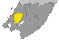 The location of Upper Hutt City within Wellington Region | |
| Country | |
| Region | Wellington |
| Territorial Authority | Upper Hutt City |
| City status | 1966 |
| Borough status | 1926 |
| Town Board | 1908 |
| Suburbs | Te Mārua, Akatarawa, Remutaka, Parkdale, Emerald Hill, Birchville, Timberlea, Brown Owl, Kaitoke, Maoribank, Upper Hutt Central, Clouston Park, Mangaroa, Maymorn, Whitemans Valley, Tōtara Park, Kingsley Heights, Elderslea, Wallaceville, Trentham, Heretaunga, Riverstone Terraces, Silverstream, Pinehaven |
| Government | |
| • Type | City Council |
| • Mayor | Wayne Guppy |
| • Deputy Mayor | Hellen Swales |
| Area | |
| • Land | 540 km2 (210 sq mi) |
| Population (June 2020)[1] | |
| • Territorial | 47,100 |
| • Urban | 44,300 |
| Time zone | UTC+12 (NZST) |
| • Summer (DST) | UTC+13 (NZDT) |
| Postcode | 5018, 5019 |
| Area code(s) | 04 |
| Website | upperhuttcity |
Geography
The Upper Hutt city centre lies approximately 26 km north-east of Wellington.[3] While the main areas of urban development lie along the Te Awa Kairangi / Hutt River valley floor, the city extends to the top of the Remutaka Pass to the north-east and into the Akatarawa Valley and rough hill-country of the Akatarawa ranges to the north and north-west, almost reaching the Kapiti Coast close to Paekakariki. Centred on the upper (northern) valley of Te Awa Kairangi / Hutt River, which flows north-east to south-west on its way to Wellington harbour, the flat land widens briefly into a 2500-m-wide floodplain between the Remutaka and Akatarawa Ranges before constricting nine kilometres further downstream at the Taitā Gorge, which separates Upper Hutt from its neighbour, Lower Hutt. The city's main urban area spreads over this plain. A smaller flood plain lies upstream, above the Kaitoke Gorge, but has experienced little urban development.
Climate
Upper Hutt has a temperate climate however due to its sheltered valley location, it generally tends to be warmer than inner city Wellington in summer and much colder in the winter. It is not uncommon in summer for temperatures to reach the mid 30s Celsius (+/- 95 °F), and in winter the temperature to drop to as low as −5 °C (about 23 °F) with regular and often heavy frost. Snow generally doesn't fall below 300 m, but in 2011 Upper Hutt sea level snow occurred twice, as part of 2011 New Zealand snowstorms. On 25 July and again between 14 and 16 August which was the heaviest blizzard in Upper Hutt since 1976 and came as a great novelty to residents. Upper Hutt receives about 1400mm of rain per year. At 17.5 °C on average, February is the warmest month, while July is the coldest at 8.5 °C.[4]
Government
Local government
Upper Hutt City Council administers the city with its surrounding rural areas, parks and reserves. Its area is 540 km², the third-largest area of city council in New Zealand, after Dunedin and Auckland. New Zealand local authorities with a large land area are usually termed districts, but Upper Hutt maintains its status as a city largely because of its high degree of urbanisation.
Upper Hutt was originally administered by the Hutt County Council, which was constituted in 1877. The Town Board was proclaimed on 24 April 1908. Upper Hutt became a Borough on 26 February 1926 and a City on 2 May 1966. On 1 April 1973, the Rimutaka Riding of Hutt County was added to the city. When the Hutt County Council was abolished on 1 November 1988, the city took over administration of the Heretaunga/Pinehaven ward, which was incorporated into the city on 1 November 1989 when the Heretaunga/Pinehaven Community Council was abolished.[5]
Parliamentary representation
Today, Upper Hutt City falls entirely within the boundaries of the Rimutaka electorate, current held by Labour's Chris Hipkins. Upper Hutt was represented by the Heretaunga electorate prior to the introduction of MMP in 1996, when the seat was merged with Eastern Hutt to form Remutaka.
Demographics
Upper Hutt is home to 47,100 people as of June 2020, of which 44,300 live in the urban area.[1]
| Year | Pop. | ±% p.a. |
|---|---|---|
| 2006 | 38,415 | — |
| 2013 | 40,179 | +0.64% |
| 2018 | 43,980 | +1.82% |
| Source: [6] | ||
Upper Hutt City had a population of 43,980 at the 2018 New Zealand census, an increase of 3,801 people (9.5%) since the 2013 census, and an increase of 5,565 people (14.5%) since the 2006 census. There were 15,870 households. There were 22,140 males and 21,837 females, giving a sex ratio of 1.01 males per female. Of the total population, 8,556 people (19.5%) were aged up to 15 years, 8,160 (18.6%) were 15 to 29, 20,658 (47.0%) were 30 to 64, and 6,603 (15.0%) were 65 or older.
Ethnicities were 81.2% European/Pākehā, 15.7% Māori, 5.7% Pacific peoples, 8.4% Asian, and 2.7% other ethnicities (totals add to more than 100% since people could identify with multiple ethnicities).
The percentage of people born overseas was 21.2, compared with 27.1% nationally.
Although some people objected to giving their religion, 48.5% had no religion, 38.5% were Christian, and 6.3% had other religions.
Of those at least 15 years old, 6,987 (19.7%) people had a bachelor or higher degree, and 6,210 (17.5%) people had no formal qualifications. The median income was $35,400. The employment status of those at least 15 was that 18,582 (52.5%) people were employed full-time, 4,557 (12.9%) were part-time, and 1,434 (4.0%) were unemployed.[6]
| SA2 name | Population | Dwellings | Median age | Median income |
|---|---|---|---|---|
| Akatarawa | 648 | 267 | 45.3 years | $40,900 |
| Birchville-Brown Owl | 3,519 | 1,359 | 38.8 years | $39,500 |
| Brentwood | 2,241 | 834 | 35.0 years | $31,400 |
| Clouston Park | 2,289 | 912 | 37.1 years | $32,800 |
| Ebdentown | 2,481 | 1,110 | 41.7 years | $29,900 |
| Elderslea | 3,429 | 1,290 | 40.7 years | $27,800 |
| Heretaunga | 2,496 | 978 | 41.6 years | $34,200 |
| Mangaroa | 2,034 | 726 | 43.7 years | $47,100 |
| Maoribank | 3,318 | 1,188 | 35.1 years | $36,000 |
| Pinehaven | 1,983 | 753 | 39.3 years | $47,000 |
| Poets Block | 2,472 | 921 | 36.0 years | $34,700 |
| Riverstone Terraces | 1,776 | 600 | 37.4 years | $53,300 |
| Silverstream | 3,531 | 1,350 | 42.8 years | $44,100 |
| Te Marua | 975 | 369 | 42.2 years | $40,600 |
| Totara Park | 2,901 | 1,083 | 36.8 years | $38,700 |
| Trentham North | 3,084 | 1,290 | 39.0 years | $28,800 |
| Trentham South | 1,809 | 480 | 41.4 years | $16,700 |
| Upper Hutt Central | 615 | 234 | 39.4 years | $41,700 |
| Wallaceville | 2,388 | 1,038 | 38.2 years | $33,900 |
| Upper Hutt City | 43,980 | 16,779 | 39.1 years | $35,400 |
Suburbs
The main suburbs of Upper Hutt, from north-east to south-west, include:
- Te Mārua, Akatarawa, Rimutaka, Parkdale, Emerald Hill, Birchville, Timberlea, Brown Owl, Kaitoke, Maoribank, Ebdentown, Upper Hutt Central, Clouston Park, Mangaroa, Maymorn, Whitemans Valley, Tōtara Park, Kingsley Heights, Elderslea, Wallaceville, Trentham, Heretaunga, Silverstream and Pinehaven.
Developments in the area include Mount Timbale Marua, Marua Downs, Waitoka Estate, Wallaceville Estate, and Riverstone Terraces. A development called The Lanes was proposed but rejected by the Lanes Commissioners appointed by the Council. This decision was made as to ensure the maintenance of the significant rural character and amenity in the Mangaroa Valley.
History
Upper Hutt is in an area originally known as Orongomai, and that of the river was Heretaunga (today the name of a suburb of Upper Hutt). The first residents of the area were Māori of the Ngai Tara iwi. Various other iwi controlled the area in the years before 1840, and by the time the first colonial settlers arrived the area was part of the Te Atiawa rohe.
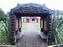
Orongomai Marae is to the south of the modern city centre.
In 1839 the English colonising company, The New Zealand Company made a purchase from Māori chiefs of about 160,000 acres of land in the Wellington region including Upper Hutt.[8] The Hutt Valley is named after one of the founders of this company.[9] Dealings from the New Zealand Company and following that, the Crown (after the Treaty of Waitangi in 1840), with local Māori regarding the land in Upper Hutt where flawed including not transacting with all the iwi that had claims on the land.[8] Disputes arose and there were skirmishes and warfare in the Hutt Valley in 1846 between troops under Governor George Grey and Māori including chiefs Te Rauparaha, Te Rangihaeata, Te Mamaku and iwi including Ngāti Toa, Ngāti Rangatahi, Ngāti Tama and Ngāti Hāua-te-rangi.[10]
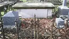
Richard Barton, who settled at Trentham in 1841 in the area now known as Trentham Memorial Park, was the first European resident.[11] Barton subsequently subdivided his land and set aside a large area that was turned into parkland. James Brown settled in the area that became the Upper Hutt town in 1848.
Having divided the land into 100 acre block, the settlers set about clearing the land of its indigenous forest and turning it into farmland. Sawmillers milled larger trees, such as Totara, for building materials and burned off the remaining scrub and underbrush.
Alarmed by unrest in Taranaki and sightings of local Māori bearing arms, settlers in the Hutt Valley lobbied for the construction of fortifications in Upper and Lower Hutt. The government and the military responded by constructing 2 stockades in the Hutt Valley in 1860. While the stockade in Upper Hutt was manned for 6 months, the threat of hostilities soon passed and neither installation ever saw hostile action.
The railway line from Wellington reached Upper Hutt on 1 February 1876. The line was extended to Kaitoke at the top end of the valley, reaching there on 1 January 1878. The line continued over the Remutaka Ranges to Featherston in the Wairarapa as a Fell railway, opening on 12 October 1878.
By the beginning of March 1914, the area of Upper Hutt controlled by the Upper Hutt Town Board had its own water supply. The supply capacity was increased when the Birchville Dam was built in 1930.
On the evening of 28 March 1914, fire broke out at the Benge and Pratt store in Main Street. An explosion killed 8 of the volunteers fighting the fire and destroyed the building.
For many years Upper Hutt was a rural service town supporting the surrounding rural farming and forestry community. Serious urbanisation of the upper Hutt Valley only started around the 1920s but from the late 1940s onwards Upper Hutt's population exploded as people moved from the crowded hustle and bustle of inner city Wellington into a more secluded yet sprawling Hutt Valley. In 1950 Trentham Memorial Park was created with an area of almost 50 hectares. In July 1955, the electrification of the railway line from Wellington to Upper Hutt was completed, allowing fast electric multiple unit trains to replace steam- and diesel-electric-hauled carriage trains. Later in November, the 8.8 km Rimutaka Tunnel opened, bypassing the Remutaka Incline and most of the existing line between Upper Hutt and Featherston, and reducing the time between the two from 2.5 hours to just 40 minutes.
Upper Hutt continued to grow in population and became a city within the Wellington metropolitan area on 2 May 1966 after the Government Statistician certified that the population had reached 20 000, allowing the Town Clerk to make application for city status.[12]
Residential subdivision in areas such as Clouston Park, Maoribank, Tōtara Park and Kingsley Heights continued into the 1980s.
In the 1980s, significant travel delays were being experienced through Upper Hutt, with State Highway 2 traffic travelling from Lower Hutt and Wellington to central Upper Hutt and further afield to the Wairarapa being funnelled down the two-lane Fergusson Drive and mixing with local traffic through Silverstream and Trentham. With central government reluctant to fund any road improvements in the area, the Upper Hutt City Council commissioned the construction of a two-laned high-speed bypass along the banks of Te Awa Kairangi / Hutt River from the Taitā Gorge in the south to Māoribank in the north. River Road, as the road became known, opened in 1987. It promptly ran at full capacity and, after several serious accidents that were a legacy of its origins, it was enlarged and re-engineered to cope with the growing traffic volume. Today, River Road is a median-divided 2+1 road from the Taitā Gorge to Tōtara Park, with two-laned undivided sections over the Moonshine Bridge and from Tōtara Park to Maoribank.
Upper Hutt is in the bed of an ancient river flood plain and as such was prone to flooding. In the 1970s and 1980s, a stop bank was built alongside the eastern side of the river from northern Upper Hutt to the mouth of Te Awa Kairangi / Hutt River in Lower Hutt to prevent further flooding.
Upper Hutt was home to one of the earliest shopping malls in New Zealand. Residents from around Wellington flocked to Maidstone Mall, however with Queensgate opening in Lower Hutt and a lack of investment the mall lost its lustre. It has now been upgraded and renamed “The Mall”, and is most notable for long serving and hard working security guard John W Burns who relentlessly wanders the shiny tile flooring usually on the top level outside the Warehouse store.
Transport
Upper Hutt is served by buses and trains planned and subsidised by Greater Wellington Regional Council under the Metlink brand. One of the North Island's major arterial roads, State Highway 2, also passes through the city and connects to the Wellington motorway system to the south and the Remutaka Hill Road to the north.
Bus
Bus services, operated by Tranzit Group under the brand TranzUrban, are centred around the Upper Hutt railway station and operate from Monday to Saturday on most routes. All of the urbanised areas of the city are served by public bus routes, and the rural areas are served by school buses.
Railway
Upper Hutt is on the Hutt Valley Line, Metlink electric trains operated by Transdev Wellington run between 4:30 am and 11 pm weekdays, (midnight Fridays), 5 am till midnight Saturdays and 6 am till 11 pm Sundays. Service which reach Waterloo in Lower Hutt in around 20 minutes and Wellington in around 45 minutes. Express peak hour weekday trains reach Wellington in around 38 minutes. Services run every 20 minutes between 6 am and 4:30 pm weekday and half hourly Saturdays, Sundays and public holidays. Evening services run hourly from 8 to 11 pm.
The railway continues beyond Upper Hutt to Masterton, becoming the Wairarapa Line, which is not electrified. Masterton is about an hour away by morning and afternoon diesel hauled trains. There are services five times a day each way Monday to Thursday, six on Friday, and twice a day each way on Saturday, Sunday, and public holidays. A notable feature of this section of railway is the Rimutaka Tunnel, the second-longest railway tunnel in New Zealand, which replaced the Rimutaka Incline in 1955.
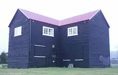
There are six railway stations within the boundaries of the city: Silverstream, Heretaunga, Trentham, Wallaceville, Upper Hutt (the main station for the city and outer terminus of electric services), and Maymorn (a request stop on the Wairarapa Line).
_08.jpg.webp)
Upper Hutt's main railway station was originally built in 1876 but has been rebuilt twice, firstly in 1955 and more recently in 2015. The most recent rebuild, jointly funded by NZTA and the Upper Hutt City Council, cost $3.5m and features a coffee bar, public toilets and upgraded ticket office featuring real time information of arrivals and departures of trains in a larger waiting room than the 1955 building.[13]
Remutaka Incline
To assist with the 1 in 15 grade of the Rimutaka Incline on the Featherston side of the range, the Fell engines that used a raised centre rail to haul trains up the steep grade were employed. The less steep 1 in 40 grades between Upper Hutt and the small settlement and shunting yard at Summit could be managed by ordinary steam locomotives. The only other rolling stock able to traverse the incline unaided were small bus-like Wairarapa railcars, colloquially known as "Tin Hares".
By the 1950s the Fell system had become too expensive to operate and was closed on 29 October 1955. To replace it, the Rimutaka Tunnel had been constructed, opening on 3 November 1955. In conjunction with the tunnel, the laying of a new route, new bridges and substantial realignment and double-tracking of the rest of the line from Wellington to Trentham had occurred by 26 June 1955.
The course of the incline is open to the public as part of the Remutaka Rail Trail.
Sports and recreation
Website
Walking and mountain-biking is popular along Te Awa Kairangi / Hutt River and on the tracks in many parks, including Karapoti (focal point of the annual Karapoti Classic), Kaitoke, Cannons Point, Tunnel Gully and the Remutaka Rail Trail. Popular team sports include Cricket, Netball, Rugby, Rugby league, Soccer, and Valley Gridiron American football.
Expressions Whirinaki Arts and Entertainment Centre is home to Upper Hutt's public art gallery including Golden Homes Gallery and Mitre 10 Mega Create Gallery, these two galleries feature a diverse programme of Local and National exhibitions. The Expressions Whirinaki complex also includes Gillies Group Theatre; the city's performing arts venue, and the civic hall known as Professionals Recreation Hall. Close by is the central library of Upper Hutt Libraries - Ngā Puna Mātauranga o Te Awa Kairangi ki Uta and swimming pool H2O Xtreme.
Upper Hutt is home to the biggest junior football club in New Zealand. The club was formed when Tararua Sports Club Inc and Upper Hutt City Soccer merged to create one club. The club now carries both of the old clubs' names. The club primarily plays its home games at Maidstone Park but also plays at Awakairangi, Harcourt Park and Trentham Memorial Park.
The city has one of New Zealand's largest Inline speed skating clubs, Valley Inline which has many successful skaters and holds the annual Speed King Tour that celebrated its 22nd year in 2012.
Popular recreation sites include:
- Staglands Wildlife Reserve at Akatarawa
- Taekwon-Do with United ITF New Zealand at Heretaunga
- Royal Wellington Golf Club at Heretaunga
- Te Mārua Golf Club at Te Mārua
- Wellington Family Speedway at Te Mārua
- Wellington Naturist Club at Te Mārua
- Kartsport Wellington Raceway at Kaitoke
- Wellington Racing Club at Trentham
- Trentham Memorial Park at Trentham
- Upper Hutt Rugby Football Club at Maidstone Park, Upper Hutt
- Rimutaka Rugby Football Club at Maoribank, Upper Hutt
- Upper Hutt United Cricket Club at Trentham, Upper Hutt
- Upper Hutt City Soccer Club at Maidstone Park, Upper Hutt
- Harcourt Park diskgolf course at Harcourt Park, Upper Hutt
- Upper Hutt Roller Skating Club at Upper Hutt
- Wellington Model Aeroplane Club Inc at Trentham, Upper Hutt
- Upper Hutt Hockey Club at Maidstone Park, Upper Hutt
Education
Primary schools
- Fraser Crescent School
- St Brendans School, Heretaunga
- Trentham School
- Birchville School
- Tōtara Park School
- St Josephs School, City Centre
- Upper Hutt School
- Plateau School
- Silverstream School
- Mangaroa School
- Maoribank School
- Pinehaven School
- Plateau School
- Oxford Crescent School
- Brown Owl Primary School
Intermediate schools
Secondary schools
- Heretaunga College
- Hutt International Boys' School, Trentham
- St. Patrick's College, Silverstream
- Upper Hutt College
Sister-city relationships
 Mesa, Arizona, United States
References
- "Population estimate tables - NZ.Stat". Statistics New Zealand. Retrieved 22 October 2020.
- "Our Maori Heritage". Upper Hutt City Council. Retrieved 8 September 2015.
- WolframAlpha
- climate-data.org
- "History of our city: Local Government in Upper Hutt". Upper Hutt City Council. Archived from the original on 9 March 2012. Retrieved 12 January 2011.
- "Statistical area 1 dataset for 2018 Census". Statistics New Zealand. March 2020. Upper Hutt City (045). 2018 Census place summary: Upper Hutt City
- "2018 Census place summaries | Stats NZ". www.stats.govt.nz. Retrieved 14 December 2020.
- New Zealand. Waitangi Tribunal. (2003). Te Whanganui a Tara me ona takiwa : report on the Wellington District. Wellington, N.Z.: Legislation Direct. ISBN 1-86956-264-X. OCLC 53261192.
- "Our history". Hutt City. Retrieved 12 October 2020.
- "War in Wellington". NZHistory, New Zealand history online. 2019. Retrieved 12 October 2020.
- "Our history and heritage". www.upperhuttcity.com. Retrieved 12 October 2020.
- "With City Status Close Upper Hutt No Snake Gully". Upper Hutt Leader. 21 October 1964. Retrieved 25 October 2017.
- Edwards, Simon (15 December 2015). "Regional collaboration gets new Upper Hutt railway station finished". The Dominion Post. Fairfax. Retrieved 23 July 2018.
External links
| Wikivoyage has a travel guide for Upper Hutt. |