Uttara (Town)
Uttara Model Town or simply Uttara (Bengali: উত্তরা) is a suburb of Dhaka, the capital of Bangladesh. The name derives from the Bengali word ut'tar meaning "north". It lies on the road to Gazipur, and adjoins Hazrat Shahjalal International Airport.
Uttara Model Town
উত্তরা মডেল টাউন | |
|---|---|
.jpg.webp) Skyline of Uttara, Dhaka | |
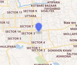
Expandable map of Uttara | |
 Uttara Model Town Location of Uttara | |
| Coordinates: 23.8667°N 90.4042°E | |
| Country | |
| Division | Dhaka Division |
| District | Dhaka District |
| City Corporation | Dhaka North City Corporation |
| Government | |
| • Ward Commissioner | Dr. Hafizul Islam Kusum[1] |
| Area | |
| • Total | 36.91 km2 (14.25 sq mi) |
| Elevation | 23 m (75 ft) |
| Population (2001) | |
| • Total | 345,097 |
| • Density | 9,350/km2 (24,200/sq mi) |
| Time zone | UTC+6 (BST) |
| Postal code | 1230 |

Uttara is a primarily planned square grid residential suburb, geographically elevated from southern Dhaka saving it from floods, and is divided into several "sectors". It can be said that Uttara is far from the congestion and pollution of Dhaka. Indeed, well into the 1990s, Uttara retained its quiet, leafy suburban character. In recent years, with the increasing influx of people moving in from the city, Uttara has evolved into a bustling town, similar to other areas of Dhaka such as Gulshan, Mohakhali, Banani, Mirpur, Mohammadpur or Dhanmondi. The suburb is well-served by a proliferation of shopping complexes, shops, and schools, colleges and Universities. Moreover the town itself is a self-centered city within greater Dhaka.
Geography
Uttara is planned by RAJUK and divided into 14 sectors, starting from sector 1 to sector 14. Originally it was planned that the odd-numbered sectors (1, 3, 5, 7, 9) were to be situated on the west side of Dhaka-Mymensingh Highway, and the even-numbered sectors (2, 4, 6, 8) on the east side. Due to increase in population, new sectors were planned but this order was not upheld and they were all developed on the west side. Uttara Residential Area (3rd Phase) project is now underway.
Demographics
At the 2001 Bangladesh census, Uttara had a population of 345,097.[3] According to 1991 figures, males constitute 54.41% of the population and females 45.59%, and about 60% of the Uttara's population are adults. Uttara has an average literacy rate of 61% (7+ years).[4]
Economy
The middle class demography has attracted the establishment of market complexes like Rajlaxmi Complex, Amir Complex, RAJUK Commercial Complex, Uttara Tower, H.M. Plaza and the likes. The increase in the upper middle class population gave rise to demand for shopping outlets, giving rise to shopping centres like North Tower, Polwel Carnation, Mascot Plaza, Tropical Alaudin Tower, and RAK Tower.
United Airways has its head office in Uttara Tower,[5] also commercial towers such as RAK Tower and ABC Tower are all at Jasimuddin Avenue in Uttara.
Best Air and Regent Airways are headquartered on Dhaka-Mymensingh Highway.
Local supermarket chains such as Agora, Nandan Megashop, Meena Bazar and Shwapno have outlets in Uttara. Also, the leading American car manufacturer Ford has its showroom situated in Abdullahpur. Aarong has its 36,000 square feet (3,300 m2) flagship outlet on the Dhaka-Mymensingh Highway. In addition to local fast food chains, many international, ice cream and coffee chains are in Uttara.
Being in close proximity to the international airport, Uttara has many hotels and bed-and-breakfasts as well.
Uttara also hosts multiple community centres such as White Hall, Ishti Kutum, Momotaz Malal, Polwel Community Center, Great Hall, etc. They host many occasions such as weddings, receptions, birthdays and various ceremonies.
Transport
Travel to and from Uttara
The Dhaka-Mymensingh Highway, is the largest highway in the city is a north–south highway pierces Uttara through its middle. The Airport Road is the only road that connects Uttara with the rest of Dhaka.
Being the northernmost thana of the Dhaka metropolitan area, Uttara serves as one of the few exits of Dhaka city.[6] Travelers exiting Uttara to outside the city will use any local buses or even taxis for short-distance travels to neighboring Tongi and Gazipur northbound on the Dhaka-Mymensingh Highway; long-haul travellers to northern Bangladesh will take coaches and exit northbound as well. Travelers entering the city centre can take buses, taxis or CNG-driven three-wheelers southbound on the highway. Travelers coming towards Uttara from within the city must travel on any bus that travels through Khilkhet and the airport to Uttara. Travelers coming to Uttara from northern Bangladesh must board a coach that enters Dhaka via Abdullahpur/Tongi, as most buses enter Dhaka city from the Gabtoli entry. Travelers coming from southern Bangladesh to Uttara must disembark at their designated stops and board a local bus to Uttara.
.jpg.webp)
The nearest railway station to Uttara is located opposite to the airport, and is called the Airport Rail Station.
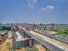
As of 2010, Uttara and Mirpur, two of the northernmost parts of Dhaka city, were not linked by any form of direct transportation link. Between the two areas, there was a large uninhabited swamp. This is to be changed as a bridge is being constructed between the two areas. The project is to be completed by 2013, and it will allow buses to travel from Uttara to Mirpur and vice versa in roughly under twenty minutes.
.jpg.webp)
Travel within Uttara
Travel within Uttara is possible on rickshaws, although rickshaws are not allowed to cross the highway. Travellers intending to travel from one side of the highway to the other must use one of the four overpasses located across Scholastica school, Rajlaxmi Complex and Amir Complex, but a significant number of pedestrians dangerously cross the 8-lane highway
Streets in some sectors may get submerged under water during heavy rainfall although drainage has improved across all sectors in recent years. All streets in Uttara are wide enough for two cars to pass. Walkways exist on broader roads; most alleyways also have walkways.
Education
Just like any other residential area in Dhaka, Uttara has a high number of educational institutions. They include:[7]
- Aeronautical Institute of Bangladesh
- Rangon Academy
- Armed Police Battalion High School
- Aeronautical College of Bangladesh
- Aga Khan School, Dhaka
- Asian University
- Atish Dipankar University of Science and Technology
- BGMEA Institute of Fashion & Technology
- Bangladesh International Tutorial (BIT)
- Blooming Flower School
- Belmont International School
- Child Plan School
- DPS STS School
- Don Bosco School and College
- Heritage International College
- Euro International School
- International Turkish Hope School, Dhaka
- Rangon Art School
- International University of Business Agriculture and Technology
- Heritage International College of Aviation Science and Management
- Life Preparatory School
- MaHaad International School
- Mastermind School
- Mastermind Play School
- Medical College for Women and Hospital
- Mileshium School
- Milestone College
- Moajjem Hossain Ideal School & College
- Nabab Habibullah School
- Oxford International School Uttara campus[8]
- Peace International School (PIS)
- RAJUK Uttara Model College
- Red Brick School
- Scholastica school
- Shaheed Monsur Ali Medical College
- Shanto Mariam University of Creative Technology
- South Breeze School
- Sunbeams School
- Sunnydale
- Time International Academy
- Uttara High School and College
- Uttara Town College
- Uttara University
- Uttara Model College
- Uttara Model School
- The Headway School
- Kids Campus School
- Green Lawn School and College
- Sky Touch School-STS
See also
References
- Dhaka South City Corporation: SiteMap. Dhakacity.org.
- "Geographic coordinates of Dhaka, Bangladesh". DATEANDTIME.INFO. Retrieved 7 July 2016.
- "Bangladesh – Dhaka Statistical Metropolitan Area". Retrieved 6 July 2011.
- "Population Census Wing, BBS". Archived from the original on 27 March 2005. Retrieved 10 November 2006.
- "Our offices." United Airways. Retrieved 2 March 2010.
- http://mydigonto.com/travel/BusRouteDiagram_files/image006.gif
- English-Medium Schools. Student-wish.com.
- "Contact Details." Oxford International School. Retrieved on 20 September 2015. "Uttara Campus House-40, Gausul Azam Avenue, Sector-13, Uttara, Dhaka-1230"
External links
- Farooque, Abu Hasan (2012). "Uttara Thana". In Islam, Sirajul; Jamal, Ahmed A. (eds.). Banglapedia: National Encyclopedia of Bangladesh (Second ed.). Asiatic Society of Bangladesh.
