Vale Summit, Maryland
Vale Summit is an unincorporated community and census-designated place (CDP) in Allegany County, Maryland, United States.[1] As of the 2010 census it had a population of 139.[2]
Vale Summit, Maryland | |
|---|---|
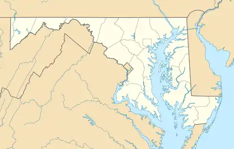 Location within the State of Maryland  Vale Summit, Maryland (the United States) | |
| Coordinates: 39°37′07″N 78°54′22″W | |
| Country | |
| State | |
| County | |
| Area | |
| • Total | 1.0 sq mi (2.5 km2) |
| • Land | 1.0 sq mi (2.5 km2) |
| • Water | 0 sq mi (0 km2) |
| Elevation | 2,030 ft (620 m) |
| Population (2010) | |
| • Total | 139 |
| • Density | 142/sq mi (55.0/km2) |
| Time zone | UTC−5 (Eastern (EST)) |
| • Summer (DST) | UTC−4 (EDT) |
| FIPS code | 24-80075 |
| GNIS feature ID | 2583699 |
Local lore indicates that the community was so named in the mid 19th century, founded by the local population of coal miners. Previously, however, it was locally known as "Pompey Smash", the origin of which is commonly believed to have come from a slave named Pompey crashing his wagonload of coal.[3] A main road through the village still bears the name "Pompey Smash Road".
A paved road reached the town circa 1921, from Clarysville, along Route 40.
References
- "Geographic Names Information System". Vale Summit (Populated Place). U.S. Geological Survey. 2009-01-29.
- "Geographic Identifiers: 2010 Demographic Profile Data (G001): Vale Summit CDP, Maryland". U.S. Census Bureau, American Factfinder. Archived from the original on February 12, 2020. Retrieved May 29, 2013.
- "1985 article from Journal of the Alleghenies" (PDF). 2011-02-21.
Municipalities and communities of Allegany County, Maryland, United States | ||
|---|---|---|
| Cities | 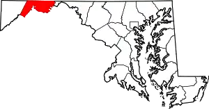 | |
| Towns | ||
| CDPs |
| |
| Other communities | ||
| ||
This article is issued from Wikipedia. The text is licensed under Creative Commons - Attribution - Sharealike. Additional terms may apply for the media files.