Loriol-sur-Drôme
Loriol-sur-Drôme (Vivaro-Alpine: L’Auriòu de Droma) is a commune in the Drôme department in southeastern France.
Loriol-sur-Drôme | |
|---|---|
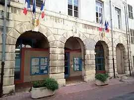 Town hall | |
.svg.png.webp) Coat of arms | |
Location of Loriol-sur-Drôme 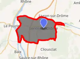
| |
 Loriol-sur-Drôme  Loriol-sur-Drôme | |
| Coordinates: 44°45′09″N 4°49′24″E | |
| Country | France |
| Region | Auvergne-Rhône-Alpes |
| Department | Drôme |
| Arrondissement | Die |
| Canton | Loriol-sur-Drôme |
| Intercommunality | Val de Drôme |
| Government | |
| • Mayor (2008–2014) | Jacques Ladegaillerie |
| Area 1 | 28.66 km2 (11.07 sq mi) |
| Population (2017-01-01)[1] | 6,593 |
| • Density | 230/km2 (600/sq mi) |
| Time zone | UTC+01:00 (CET) |
| • Summer (DST) | UTC+02:00 (CEST) |
| INSEE/Postal code | 26166 /26270 |
| Elevation | 81–365 m (266–1,198 ft) (avg. 108 m or 354 ft) |
| 1 French Land Register data, which excludes lakes, ponds, glaciers > 1 km2 (0.386 sq mi or 247 acres) and river estuaries. | |
Loriol is situated in the Rhône valley, between Valence and Montélimar. The neighbouring villages are Livron-sur-Drôme, Mirmande, and Cliousclat.
History
Roman emperor Aurelian is said to have based a camp here. The medieval fortress was destroyed in the wars of religion, leaving only the ramparts.
During World War II, Loriol was heavily damaged by Allied bombing in August 1944.
Population
|
|
See also
References
- "Populations légales 2017". INSEE. Retrieved 6 January 2020.
| Wikimedia Commons has media related to Loriol-sur-Drôme. |
| Authority control |
|---|
This article is issued from Wikipedia. The text is licensed under Creative Commons - Attribution - Sharealike. Additional terms may apply for the media files.