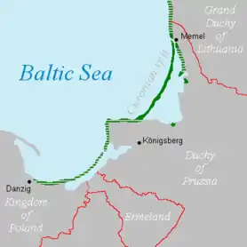
Vistula Spit
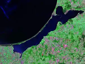
The Vistula Spit (Polish: Mierzeja Wiślana; Russian: Балтийская коса; German: Frische Nehrung) is an aeolian sand spit,[1] or peninsular stretch of land, which separates Vistula Lagoon from Gdańsk Bay in the Baltic Sea, with its tip separated from the mainland by the Strait of Baltiysk. The border between Poland (Pomeranian Voivodeship) and Kaliningrad Oblast, an exclave of Russia, bisects it, politically dividing the spit in half between the two countries. The westernmost point of Russia is located on the Vistula Spit. The Polish part contains a number of tourist resorts, incorporated administratively as the town of Krynica Morska.
Geography
Situated in the Gdańsk Bay this narrow headland (spit) is on average a few hundred meters wide (widest point is 1.8 km (1.1 mi)) and with a length of 70 km (43 mi) twice as long as the more populous Hel peninsula in the western bay. The Vistula Spit streches in a north-easterly direction and separates the Vistula Lagoon from the southern Baltic Sea. The spit consists of 10 to 12 meter high marine sand, accumulated during three dune generations.[2] The highest peaks of the Vistula Spit are the Kamelberg and the imposing 25 m (82 ft) high shifting dune of Narmeln on Russian territory.[3]
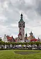
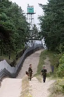
The border between Poland (Pomeranian Voivodeship) and Russia (Kaliningrad Oblast) runs across the spit. At the southern end of the Vistula Spit lies the village of Kąty Rybackie (Bodenwinkel). At the road to the northeast lies the village Skowronki (Vogelsang) and the towns of Borowo, Przebrno, Lipe, followed by the seaside resort town of Krynica Morska, (Kahlberg). Nowa Karczma (also Piaski, formerly Neukrug), lies approximately 3 km (1.9 mi) southwest of the Polish-Russian border. All Polish settlements belong to the Pomeranian Voivodeship.[4]
On the 18 km (11 mi) long northeastern part on the Russian side lies the port city of Baltijsk (Pillau) just north of the exit Strait of Baltijsk. The former German, later Soviet and now Russian Neu Tief air force base is inhabited by around 1,000 people and can be reached by ferry from Baltijsk.[5]
History
Until the 13th century, the spit had navigable straits in the middle, which allowed the city of Elbing, part of the monastic State of the Teutonic Knights, direct access to the Baltic Sea. The natural closing of the straits in the late 13th century reduced Elbing's status as an important trading seaport. This and the Teutonic takeover of Danzig (Gdańsk) and Polish Pomerania in 1308 led to the increased importance of Gdańsk.
During World War II, it became the last holdout of the remaining German soldiers in East Prussia, although the Soviets simply bypassed the spit after the East Prussian Offensive was decisively concluded, training their sights on the more important goal of capturing Berlin. The last Wehrmacht soldiers laid down their arms after the German Instrument of Surrender was signed.
Kursenieki
While today the Kursenieki, also known as Kuršininkai are a nearly extinct Baltic ethnic group living along the Curonian Spit, in 1649 Kuršininkai settlement spanned from Memel (Klaipėda) to Danzig (Gdańsk). The Kuršininkai were eventually assimilated by the Germans, except along the Curonian Spit where some still live. The Kuršininkai were considered Latvians until after World War I when Latvia gained independence from the Russian Empire, a consideration based on linguistic arguments. This was the rationale for Latvian claims over the Curonian Spit, Memel, and other territories of East Prussia which would be later dropped.
Transport
The Polish side of the peninsula is accessible using Voivodeship road 501. There is at present (2016) no border crossing between Poland and Russia on the peninsula.
Vistula Spit canal
In 2019, the Polish government started the building of a ship canal across the peninsula, which will permit ships to enter the Vistula Lagoon and the port of Elbląg, bypassing the current transit route through the Russian Strait of Baltiysk.[6]
References
- Kramarska, R Uścinowicz, S Zachowicz J and Kawińska M, Origin and evolution of the Puck Lagoon in Journal of Coastal Research Issue 22, 2005, P187
- Eric Bird (25 February 2010). Encyclopedia of the World's Coastal Landforms. Springer Science & Business Media. pp. 633–. ISBN 978-1-4020-8638-0.
- "Wegen Kaliningrad: Polen baggert eigenen Ostseekanal". MDR. September 11, 2017. Retrieved September 19, 2020.
- Wolfgang Albrecht Stromer von Reichenbach (1676). Speculum Germaniae oder ein kurtzer geographischer Bericht von dem gesammaten Teutschland. pp. 4–.
- Gerald Schernewski (13 May 2002). Baltic Coastal Ecosystems: Structure, Function and Coastal Zone Management. Springer Science & Business Media. pp. 134–. ISBN 978-3-540-42937-1.
- RDLP: wycinka na Mierzei Wiślanej jest zakończona
External links
- Vistula Spit (in Polish and German)
- Russia's Strategic Strip Of Sand and Sea Faces Tourist Assault on YouTube, Radio Free Europe/Radio Liberty, published on Mar 28, 2019
| Wikimedia Commons has media related to Vistula Peninsula. |