Viswema
Viswema is a Southern Angami Naga village located 22 km south of Kohima, the capital of Nagaland, India. With a resident population of 7417, it is the second biggest village in the state and is part of the contiguous built-up of the Kohima metropolitan area that extends into the neighboring areas of Jakhama, Kigwema and Khuzama in the Southern Angami region, forming the second largest urban agglomerations in Nagaland. Its vast territory also lies across the inter-state boundary in Manipur where notable features including Mount Tempü(Iso) at 9822 feet (2994m) also the highest peak in Manipur, the thick forest of Kezol–tsa and a major portion of the Dzüko Valley is located.
Viswema | |
|---|---|
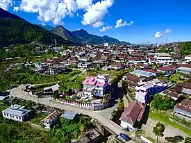 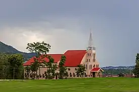 From Top : Partial aerial view of Viswema, Viswema Catholic Church | |
| Coordinates: 25.5607°N 94.1463°E | |
| Country | |
| Region | Northeast India |
| State | |
| District | Kohima |
| Government | |
| • Type | Village Council |
| • Chairman | Zhotoho Kiso |
| • Body | Viswema Village Council |
| Elevation | 1,631 m (5,351 ft) |
| Population (2011) | |
| • Total | 7,417 |
| • Demonym | Viswe–mi viswe–miko so tteyo phi–mi |
| • Dialect | Keyho |
| Time zone | UTC+5:30 (IST) |
| PIN | 797005 |
| Vehicle registration | NL-01 |
| Sex ratio | 1074 ♂/♀ |
| Climate | Temperate (Köppen) |
| Website | nagaland |
It is considered to be one of the oldest Tenyimi village with most Chakhesang villages and also many other Angami villages pointing their origin towards Viswema.[1]
Etymology
Traditionally referred to as Viswe–ra, a name given by its historical ancestor Keyho which loosely translates to as ‘A place of people with Virtue and Integrity’.
Viswema is also known as Ve-sr-wü–ra by the Chokri Chakhesangs and Shüna–mai by the Ememei Maos.
History
Early period
The history of Viswema, according to oral history begins with the founding of Kipizwü, some two km west of the village by Viswe. Viswe was a descendant of Keyho.
The ancestors lived there for several generations till the invasion of the Burmese-Karens, who were known to Viswe–miko as Kherenümi. The defeat inflicted on the Burmese invaders gave a sense of confidence and Viswe–mi became more assertive and grew in great numbers. They began to move out in search of suitable environment for permanent settlement. They therefore came down to the present site of the village.[2]
In the past Viswema was known for making fine pottery ware. For any function and rituals earthen pots were purchased from Viswema by neighboring communities.[3]
Pre-Modern era
Invasion of the Manipuri armies
- Oral history.
The Manipuris invaded Viswema twice, but could not succeed in subduing it. However, after the end of the Anglo-Naga war in 1879 the British occupied Kohima and setup a military post and built strong barricade around the station with armed police. But the garrison was besieged by Naga warriors. Meantime the British sought help from the Manipuri Raja. The Manipuri Raja Chandrakirti Singh led around a thousand of his army and rushed to Kohima and after a brief engagement with the Naga warriors lifted the sieged and saved the British.
The Manipuri Army went on a rampage and captured a Kohima boy and buried him alive in the heart of the town. They covered the grave with a huge stone on which the foot print of the Manipuri Raja was engraved. This stone was removed by the Naga Youth Movement leaders in 1956.
At the time of the Manipuri army withdrawal from Kohima, the Viswe–miko left their village and hid their food grains in trenches and waited for their return from Kohima. When the Manipuris arrived and finding none set the village ablaze and proceeded homewards. Viswema warriors then attacked them from the rear, throwing them in confusion and disorder. Many were killed and their arms looted, while the rest fled to their country.[2]
Modern era
World War II
When the Japanese and INA soldiers entered Naga Hills in early April 1944, many of them stayed at the outskirt of the village. They dug trenches and built strong bunkers everywhere in the vicinity of the village. Since the Allies operation against Japanese occupation of Kohima, Viswema was continuously hit by explosive missiles which were fired by cannons from Kohima and later on from Kigwema as launching pads. Many people were killed and injured. On 10 June 1944, a message from the Allies sources was conveyed to the village elders telling them to evacuate their village. The village was evacuated the next day. Bombings on 14 June continued till the village which had more than 600 houses at that time was completely razed to the ground. The same evening the Japanese forces at Viswema retreated to the route by which they had entered Naga Hills two months back. Viswema was then taken over by the Allies.[2]
2010 Mao Gate Incident
On 5 May 2010, Thuingaleng Muivah the present General Secretary of the NSCN-IM arrived at Viswema on his way to his home village of Somdal in Ukhrul district, Manipur which was strongly opposed by the Manipur government. Muivah stayed overnight at Viswema which was nearby on the inter-state border.[4] The next day thousands gathered at Mao Gate to protest against the Manipur State Government's decision to prevent the entry of Muivah into Manipur but however violence broke out between the civilians and security forces stationed at the Manipur-Nagaland border. On that fateful day, two students were killed in indiscriminate firing by security forces of Manipur. Scores were injured.
Geography
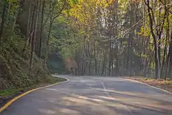
Viswema is situated at 1,631 m (5,351 ft) above sea level on the eastern part of the Barail mountain range. It is bounded on the west by Zeliangrong villages, on the north by Jakhama, on the east by Kidima, on the south-east by Pudunamei (Manipur) and on the south by Khuzama.
Topography
The Jakhama boundary on the north is marked by a river known as Kerho–l and on the south, the Khuzama boundary is marked by another river known as Chokhwi–l or Kezo–l. Both the river flows in parallel direction to meet at the Dzü-ü river which later flows into the biggest river in Nagaland—the Doyang in Wokha District.
Mount Tempü, the highest peak in Viswema (also the highest peak in the present day state of Manipur) with an altitude of 2,994 m (9,823 ft) above sea level,[5] the highest elevation of the surrounding area is located to the south western part of Viswema. Its summit can be reached easily by the Khiyoke route.
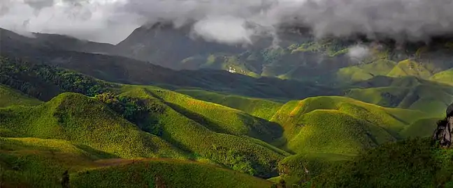
On the western side is the Dzüko Valley which includes a range of hillocks, the valley is drained by the Dzüko River which flows in a westerly direction forming the present day inter-state boundary between Nagaland and Manipur. On its west side, the Dzüko valley is flanked by the thick wooded Kezol–tsa forest which has diverse species of flora and fauna.
Climate
Viswema has warm summers and cool dry winters. Snow falls occasionally on higher altitudes.
Demographics
Viswema is located in Jakhama sub-division of Kohima district, Nagaland with total 1369 families residing. It has a population of 7417 of which 3576 are males while 3841 are females as per Population Census 2011.[6]
In Viswema the Average Sex Ratio is 1074 which is higher than Nagaland state average of 931. Child Sex Ratio for the Viswema as per census is 1076, higher than Nagaland average of 943.
Culture and attractions
Festivals
Apart from the major religious festivals like Christmas, Easter, etc. the village also celebrates several local festivals.
- Te–l Khukhu
Te–l Khukhu is a festival that falls on 13 July (Chünyi). It is a time of giving and sharing of food with each other. This is the only festival dedicated for girls. Come July and the young damsels are abuzz with preparations for the Te–l Khukhu festival. They start collecting wild flowers in advance to decorate the particular Chokrwu (eaves at the entrance of a house) they decide on. The most common flowers are Khwüso Pü (Ginger lily, Hedychium aurantiacum wall), Phakü Pü (Rock butterfly lily, Hedychium ellepticum Buch), Terü su and Tsakoshe Pitha Nü (Tender Maize). Gone were the days when different animistic rituals were performed but with the advent of Christianity the rituals were no longer performed. Today it is celebrated as a time of get-togetherness and sharing the little you have with your dear and near ones.[7][8]
Places of interest
- Dzüko Valley
The main entry to Dzüko Valley is from Viswema where one can travel to the rest house above Teyozwü by a Tata Sumo taxi. From here one has to climb forty minutes to the top of the mountain. This is where Dzüko starts but the main valley is still another two hours walk away.
- Mount Tempü
This is the highest peak in Viswema situated at an altitude of 2994m above sea level. The best time to visit this peak is during the snow covered winter months.
- Teyozwü
This is a hill located between Viswema and the Dzüko valley.
- Hope garden
This is a garden located above Viswema on the way to Dzüko valley. It is also a part family burial ground of a Zheri–mi clan.
Cuisines
- Zawo or commonly known as Galho among the Angamis is also a popular dish in Viswema. It is a mix dish made of rice, vegetables and various meats.
- Mesü is pork or beef cooked with its blood. It is a common cuisine among the Tenyimis but the Mesü of Viswema is considered to be the best.
Film
Some portion of the 2005 film Were I the Moon? The Legend of Sopfünuo was filmed in Viswema.[9]
Education
Viswema has a higher literacy rate compared to Nagaland. In 2011, the literacy rate of Viswema was 80.69% compared to 79.55% of Nagaland. In Viswema Male literacy stands at 86.91% while female literacy rate was 74.89%.[10]
Educational Institutions in Viswema:
- St. Joseph's Higher Secondary School
- John Government Higher Secondary School
- Viswema Baptist School
The St. Joseph's College, Jakhama is located about two km from Viswema.
Government and politics
Government
Viswema is headed by the chairman of the Viswema Village Council. The council does not only represent the citizens of Viswema but every citizens of Viswe–mi residing in and outside Viswema. The council is responsible for customary practices, public safety, welfare services, etc. The chairman and council members are elected to five-year term. The term for the chairman and council members lasts five years and only has a one term limit.
Politics
Viswema falls under Southern Angami–II Assembly Constituency of the Nagaland Legislative Assembly.
- Notable political leaders
- Vizol Angami (1914–2008), Chief Minister of Nagaland (1974–1975; 1977–1980).
- Vizadel Sakhrie (1943–1995), former Minister of the Nagaland Legislative Assembly.
- Zale Neikha, present Member of Legislative Assembly from Southern Angami-II constituency.
- K. Viswesül Pusa (1954–2017), former Minister and Veteran Congress leader.
- Zaku Zachariah Tsükrü (1947–2017), former Vice President of the Naga People's Front
- Kropol Vitsu (b. 1964), former Member of Legislative Assembly from Southern Angami-II constituency.
Transportation
Airports
The nearest airport is Dimapur Airport at Dimapur near the Assam border about 96 kilometres (60 miles) away. The airport serves domestic flights to and from the country.
The Bir Tikendrajit International Airport is located about 120 kilometres (75 miles) south of Viswema.
Both the airports are linked to Viswema by the Asian Highway 1.
Roadways
Highways passing through Viswema
 Asian Highway 1 : Tokyo - Viswema - Istanbul
 NH 2 : Dibrugarh (Assam) - Viswema - Tuipang (Mizoram)
Viswema is well connected by road with the AH1 and also the NH-2 and the state highway connecting it with the various parts of Kohima district and also the neighboring Phek district through Viswema. Taxis from Kohima to Viswema are also available.
Rail
The Dimapur Railway Station serves as the nearest railway station to Viswema. The currently under-construction Zubza Railway Station on the Dhansiri–Zubza line once completed will serve as the nearest railway station from Viswema.
Notable personalities
Throughout its history, a sizeable number of people of Viswema descent have become notable in many varied fields. Among its notable personalities are prominent figures in the state such as:
- Vizol Angami, The fourth Chief Minister of Nagaland and also the first Naga pilot (Royal Indian Air Force during World War II)
- Holshe Khrie-o, Nagaland State Sepaktakraw coach
- Viseyie Koso, The first Naga sportsman to represent India at an Asian Games (2010 Asian Games held in Guangzhou, Guangdong, China)
- Zale Neikha, Present member of Nagaland Legislative Assembly from Southern Angami–II (constituency)
- Vizadel Sakhrie, The first Naga Medical Specialist
- Hovithal Sothu, Project Director at TAFMA
Notes and references
- "Acoustic analysis of vowels in two Southern Angami dialects". www.iitg.ac.in. Retrieved 14 May 2020.
- Vizol Khamo, Akhale.:Towards a Better World, 2016. Heritage Publishing House. Dimapur.
- Nepuni, William.: Socio-cultural History of Shüpfomei Naga Tribe, 2010. Mittal Publications. New Delhi.
- "Muivah heads home despite Manipur ban". Indian Express. Retrieved 13 July 2020.
- Mekr0, Y. (2014) Rocks of Nagaland. Mittal Publications. p 80.
- "Census2011, Viswema village Data".
- Sothu, Neithono.: Resurgence, 2013. Viswema Students' Union. Viswema. pp. 36–37.
- "Viswema celebrates Te–l Khukhu festival". Eastern Mirror Nagaland. 7 July 2017. Retrieved 22 December 2020.
- "Folklore premiere in Naga film - Young filmmaker turns popular tale of a gritty woman into celluloid". The Telegraph. 6 January 2006. Retrieved 22 August 2020.
- "Literacy rate in Viswema as per Census 2011".
External links
| Wikimedia Commons has media related to: |
