Ukhrul district
Ukhrul District (Pron:/ˈuːkˌɹəl or ˈuːkˌɹʊl/) is an administrative district of the state of Manipur in India with its headquarters at Ukhrul, that is Hunphun.[2][3][4][5][6][7][8][9] The district occupies the north-eastern corner of the state and it extends between latitudes of 24° 29′ and 25° 42′ N and longitudes 94° 30′ and 94° 45′ E approximately (including Kamjong district). It shares an international boundary with Myanmar (Burma) on its eastern side and is bounded by Nagaland state in the north, Senapati district and Kangpokpi district in the west and Kamjong district in the south. It has the distinction of being the highest hill station of Manipur. The terrain of the district is hilly with a varying heights of 913 m to 3114 m (MSL). Ukhrul, the district HQ., at an altitude of 2020 m (MSL) is linked with Imphal, the state capital by NH 202 which is about 84 kilometres apart. The district covers an area of 4,544 square kilometres (1,754 sq mi) including Kamjong district making it the second largest district of the state after Churachandpur district and has a population of almost 1,83,998 according to Census of India 2011 comprising about 6.44 per cent of the total state population.The Tangkhul Naga tribe constitute the major bulk of the population with other communities such as Kukis, Nepalese and other non-tribals constituting a small percentage of the district population. Administratively, the district which comprises around 200 villages was divided into five sub-divisions, where their boundaries were coterminous with that of the Tribal Development Blocks. There was no statutory town in the district except one census town which was formed in 2011 Census. Recently, Kamjong district[10][11][12][13] was carved out from Ukhrul District as a separate district. Ukhrul District has three assembly constituencies before the bifurcation of the district which are Phungyar Assembly Constituency (43-ST), Ukhrul Assembly Constituency (44-ST) and Chingai Assembly Constituency. The district is best introduced by its rare Shirui Lily, (Lilium mackliniae). Also, the district has provided two of Manipur's chief ministers and the only from amongst the hill districts of Manipur, Yangmaso Shaiza the first tribal chief minister of Manipur and Rishang Keishing who is also the first MP from Outer Manipur (Lok Sabha constituency). William Pettigrew (missionary), an educationist and a Scottish-British Christian Missionary pioneered the western system of education and introduced the Christianity faith among the Tangkhal Naga tribe. Phungyo Baptist Church, Tangrei, Ukhrul, the oldest and the first Christian church of Manipur which still stands today is a testament to his passion for missionary work.[9]
Ukhrul District | |
|---|---|
District of Manipur | |
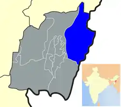 Location of Ukhrul District in Manipur | |
| Coordinates: 25°18′N 94°27′E | |
| Country | |
| State | Manipur |
| Formation | 1969 |
| Headquarters | Ukhrul |
| Area | |
| • Total | 4,544 km2 (1,754 sq mi) |
| Area rank | 2 |
| Elevation | 3,114 m (10,217 ft) |
| Population (2011)[1] | |
| • Total | 183,998 |
| • Rank | 7 |
| • Density | 40/km2 (100/sq mi) |
| Demonym(s) | Tangkhul |
| Time zone | UTC+5:30 (IST) |
| Pincode(s) | 795xxx |
| Vehicle registration | MN |
| Literacy | 81.35 % |
| Official languages | Tangkhul |
| Website | ukhrul |
History
It was marked out first as a sub-division in 1919 during the British Raj. It was later upgraded to a full-fledged district, bearing the nomenclature of Manipur East District in November 1969 by the Government of India.
Linguistically, the Tangkhuls belong to a large language family called Sino-Tibetan, and within that family to the sub-family Tibeto-Burman. In general this points towards an origin in the north, that is south-west China and Tibet. The earliest home of the Tangkhuls was the upper reaches of the Huang heo and Yangtze Rivers which lies in the Zinjiang province of China. Like the other desert areas of the world, the people including the Tangkhuls, due to hardship of life, dispersed from this place to different directions. One group moved towards the east and southeast to be become known as Chinese, and another group moved southward to become the tribes of Tibeto-Burman, which includes the Tangkhuls and other tribes. That was between c, 10,000 B.C. to 8000 B.C. This movement has continued into recent historic times. S.K. Chatterjee noted that from 2000 B.C. onwards, Sino-Tibetan speakers from China pushed south and west and entered India. According to W.I. Singh, in his The History of Manipur, the Tangkhuls settled in the Samshok (Thuangdut) area in Myanmar. They belong to the Yakkha tribe in China. The Tangkhuls were first noticed in Manipur by Poireiton, one of the earliest kings of a principality in Manipur valley.
The Tangkhuls and other Naga tribes came to Manipur, Nagaland, Assam and Arunachal Pradesh through Myanmar. Some of them also settled down in Myanmar and did not venture further. However, their movement over Myanmar and into India was spread over a period of time. They entered the present habitat in waves following one another and in some cases in close succession. The Tangkhuls came together with the Zeliangrongs, Maos, Poumeis, Marams and Thangals because all of them have references to their dispersal from Makhel, a Mao village in Senapati district. They had also erected megaliths at Makhel in memory of their having dispersed from there to various directions.
The Tangkhuls point to the association of their forefathers with the seashore. Most of the ornaments of the Tangkhuls such as kongsang and huishon were made of sea shells. Cowrie and conch shells are prominent features of the people who live on the shore.
By the 2nd century AD the Tangkhuls were living in Samshok (Thuangdut) in Myanmar. Ptolemy, a Greek astronomer and geographer of Alexandria, in his Geography of Further India c. 140 AD, referred to the Tangkhul (Nangalogue) at Triglypton (Thuangdut). The Tangkhuls began to disperse from Samshok after the invasion of Ko-lo-feng and his successor I-mau-shun the king of Nan-chao in the closing part of the 8th century AD and beginning of the 9th century AD. They were further driven towards the north-west of Myanmar by the Shan people.
Thus, the Tangkhuls as also other Naga tribes travelled from China to Myanmar, and from there finally they came into their present land traversing through innumerable snow-covered landscapes, mountains and wild forests, confronting wild beasts and wild tribes. The exodus of the Tangkhuls from China to Myanmar and finally to India is a story of heroism of human migration, courage and endurance.
In course of time every Tangkhul village became a small republic like the Greek city states. Every village had an unwritten constitution made up of age-old conventions and traditions. The Tangkhul villages were self-sufficient except for salt, and self-governing units ruled by a hereditary or elected chief assisted by a council of elders. The chief was a judge, administrator and commander rolled into one. However, the absence of a national government was disastrous for them in the mediaeval period as the small village states were unable to withstand the onslaught of the organised army invasion like Khagi (Chinese), Awa (Burmese), etc. The Kangleipak king or Meitei king always protects his people from foreign invasion. Some examples of historic events like during the reign of King Telheiba 1335-1355 AD protected from Khagi Army (Chinese) and Awa Army (Burmese) invasion. During the reign of King Khagemba 1596-1651 AD of Kangleipak Kingdom, he just not only protected Chinese invasion but even defeated and conquered a Chinese Chieftain rule town somewhere in the present Yunan provinces of China.
The ancient Tangkhul history is hitherto an unrecorded past. History however became more enlightened by the beginning of the 13th century owing to the cultural, trade and sometimes turbulent relations which had grown up with the people of the valley. There is a reference to the Tangkhuls as early as the 13th century during the reign of Thawanthaba (1195-1231 AD) of Kangleipak Kingdom. The chronicles refer to the punishment in some hill tribe villages for not giving their protection tax to their king. The most severe punishment was for cutting down a tree unnecessarily. The Kangleipak King had a strict rule against deforestation. For example, a law said that if one cuts a tree, he must plant a tree somewhere around. The Meitei believed that cutting down excess trees cause floods in the valley and landslides in the hills area country road, which make the army patrol team difficult to keep an eye of protection for their capital kingdom within the nine mountain ranges. The particular village's chief had to pay the price as a punishment for disturbing mother nature if he was found guilty in trial. Even in many a case the hierarchy Chieftain Hood position was alter with their sibling if a particular village chief act against the king's order. So there was a growth of anti-Meitei sentiment since early days. A historical proof of separatist rebellion when King Tabungba (1359-1394) was assassinated by Chingdai village chieftain while he was there for taking direct consent from the village chief for not showing up in the religious ancestral festival of Mera Hou Chongba for Kangleicha (people of Kangleipak). It was well known that Chingdai village chief wife (daughter of Chingsong village chief) was a childhood lover of King Tabungba while they were young, before he took the throne in 1359.
There has always been some form of relationship between the Tangkhuls and the Meiteis in terms of political alliances and trade relations. Some items of Hao (Highlander of Kangleipak Kingdom) material - culture indicate a long history of contact between the plain and hills. The "Elephant Cloth" (Leirungphi), for instance, resplendent with complex animal designs, worn by the Hao of Manipur, has its origin in the wish of the ruler of Manipur in the mid-seventeenth to present his village's chief with a special cloth. The Tangkhul shawl "changkhom" is also known as "karaophi" in Manipur. The Tangkhul dance (pheichak) was known as "chingkheirol" in Manipur, from the fact that it came from Chingkhei (north east of Imphal).
During the reign of the most powerful Meitei King Pamheiba a.k.a. Garib Nawaz (1709–1748) for the first time, the heartland rebellion area of the Tangkhul villages was brought under peace. In 1716, the king's forces invaded the great Tangkhul village of Hundung and 68 prisoners were captured. In 1733, the king sent a military expedition to Ukhrul to destroy the rebellion force. The outcome of the expeditions incurred heavy casualty on the King's forces; the royal chronicles record the death of 70 Meitei soldiers. The Ningek inscription of King Garib Nawaz refers to the Khullakpa of Okhrul (Ukhrul). Ukhrul was the headquarters of the Tangkhul Long (Tangkhul Assembly), as well as the Tangkhul annual fair locally known as "Leh Khangapha" used to be held at Somsai in Ukhrul.
A more significant relationship between the hills and the valley took place during the reign of Bhagyachandra (1759–1762 and 1763–1798). In 1779 King Bhagyachandra established a new capital at Langthabal about seven kilometers south east of Imphal. For the next 17 years Langthabal remained as the capital. He employed many Tangkhul and Kabui Nagas in the digging of moats around the new capital of Langthabal. Of the Tangkhul chiefs, Khullakpa of Hungpung and Hunphun made friendship with the king.
The relationship between the Tangkhuls and the Meiteis during the mediaeval period was not only of wars and conquests. They also carried out trade and commerce. The Tangkhuls supplied cotton to the valley. They also sold and purchased in the Sanakeithel, the principal market in Imphal. The Tangkhuls used Manipuri coins of bell-metal locally called "sel" as a medium of exchange which was first introduced during the reign of Khagemba (1597–1652).
The boundary of Manipur and Burma (Myanmar) was laid down by an agreement signed between the British authorities (East India Company) and Burma on 9 January 1834 on the river bank of Nighthee (Chindwin). The Article No.4 (iii) of this agreement relates to the Tangkhul villages. In the period of World War II, the Ukhrul area was also affected by war. Gnanpeeth awardee recorded about this area that in the 1950s the highway between Imphal and Ukhrul was partially demolished, and hill areas in Ukhrul had signs of war attacks. People and their hearts also seem to be wounded out of war.[14] "Fourth (iii) - On the north, the line of boundary will begin at the foot of the same hills at the northern extremity of the Kabo Valley and pass due north up to the first range of hills, east of that upon which stand the villages of Chortor (Choithar), Noongbee (Nungbi), Nonghar (Nunghar), of the tribe called by the Munepooriis (Manipuris) Loohooppa (Tangkhul), and by the Burmahs Lagwensoung, now tributary of Manipoor."
As a result of this boundary demarcation without the knowledge let alone consent of the Tangkhuls, many Tangkhul villages situated in Somrah hills are included under Burma. Later, when India and Burma attained national independence, the Tangkhuls found themselves totally dismembered belonging to two different countries.
Geography
Ukhrul District occupying the northeastern corner of the state lies between latitudes of 24° 29′ and 25° 42′ N and longitudes 94° 30′ and 94° 45′ E approximately (including Kamjong district). Nagaland bounds the district on the north, Kamjong District on the south, Myanmar (Burma) on the east and Senapati and Kangpokpi Districts on the west. The north-south extension is longer than the east-west. The total area of the district is 4,544 square kilometres (1,754 sq mi) including Kamjong District. It has the distinction of being the highest hill station of Manipur. The terrain of the district is hilly with varying heights of 913 m to 3114 m (MSL). The highest peak is the Khayang Peak, at 3114 m (MSL), though the more popularly known peak is the Shirui Kashong Peak, at 2,835 m (MSL). Most of the major rivers originate from the crevices and slopes of this Shirui Peak. The terrain of the district is rippled with small ranges and striped by few rivers.
The northern hilly region occupies the northern portion of the district and lies between the Akhong Lok or Laini Lok river and Chammu river. A big range stretches from north to south starting from near Jessami to Shirui Kashong as high as 2,568 metres above the MSL. The eastern hilly region occupies the eastern part of the district that lies east of the Chammu and Maklangkhong rivers. The Gamgimol or Nehdoh Lhang range forms an International boundary with Myanmar. The southern hilly region is situated at the southwestern corner of the district, which divides the Maklangkhong and Taret rivers. The district is drained by the two river systems, the Chindwin River system in the north and the Manipur river system in the south-west.[2]
Flora and fauna
The district is home to hundreds of varieties of trees and flowering plants, orchids, epiphetic ferns, varied species of plants and shrubs. Some of the best known species of plants and trees includes Alder (Alnus nepalensis), Prunus cerasoides, Acacia auriculiformis, Parkia javanica, Paraserianthes falcataria, Michelia, Gmelina arborea, Pinus kesiya, Robinia pseudoacacia, besides various Iris (plant) species, wild roses, red and white rhododendrons etc. The district being covered with a wide dense of forest is a habitat of wild animals such as Elephant, Leopard, Tiger, Bear, Bison, Gaur, Crested porcupine, Pangolin, Jungle cat, Wild boar, Deer, Monkey etc. The state flower of Manipur, Shirui Lily, also called Shirui Lily or Lilium Macklinae is a rare pinkish white flower found only in the Shirui Hill Range in the Ukhrul District of Manipur. It is named after Jean Macklin, the wife of Dr. Frank Kingdon-Ward who spotted the flower in 1946 while collecting botanical specimens. The Royal Horticultural Society (RHS), London, United Kingdom, one of the world’s leading horticultural organizations honoured the Shirui Lily with its prestigious merit award at its Flower Show in London in 1948. The local name of the flower is KASHONGWON. According to legend, the Kashongwon is also the protective spirit which resides on the Shirui Peak. HORAMWON is also another flower which is snow-white. It takes its name HORAMWON (snow-white) from the snow that falls on Shongrei Peak where the flower blooms. Other names of flowers worth mentioning are Chamtheiwon, Nulsiwon, Shiriwon, Sikreiwon, Shilungwon, Kokruiwon (Rhododendron arboreum), Khayawon, and Muivawon (Ref: A Tourist guide to Shirui Lily). The evergreen forest presents the district with a sylvan landscape. Some commonly found trees are Pine, Albizia, Castanopsis, Mesua, Mangifera indica, Phoebe hainesiana, Albizia lebbeck, Teak, Oak etc. The forests are also interspersed with multi-bamboos especially in the southern portions.[2]
Though the State Flower, Shirui Lily have attracted many tourists and botanists from around the world, it now faces a crisis of possible extinction in the near future and has been categorized as an Endangered species due to climate change, deforestation, wildfire, poor conservation approaches, intrusion of other plants and bushes, over exploitation etc. Scientists and experts have advocated for the Shirui Lily to be left as it is in nature, and assured us that nature is capable of healing it without human interruptions caused by a forest fire and unguided tourists. They have also suggested number of steps and measures that can be taken up by the centre and state government and participation of various research institutions to raise awareness of protection of Shirui Lily and implementation of conservative initiatives.[15][16]
Climate
The climate of Ukhrul district is sub-tropical monsoon type. The climate of the district is of temperate nature with a minimum and maximum degrees of 3°C to 33°C. The average annual rainfall is 1,763.7 mm (1991). As the district headquarter lies on the top of the high hills, it is very cold throughout the year. It is always covered by the clouds. Regarding weather of the District Headquarter, the sudden changes of the position of clouds are openly seen within a few moments but in other places outside the District Headquarter, it is hot in summer and very cold in winter. However, the district as a whole have a moderate temperature.
The hill ranges that lies in the District Headquarter and Ukhrul Central sub-division got very cold climate during the winter while other parts of the vast hilly areas of the district has moderate climate throughout the year. The coldest months of the district are December and January. During this period, the temperature at the Ukhrul District Headquarter use to come down to as low as 3°C and even 0°C.
Administrative divisions
The present district was made a full fledged district as Manipur East District in 1969. The village, Ukhrul, became its headquarters comprising Ukhrul North, Ukhrul Central, Phungyar Phaisat, Kamjong Chassad, Ukhrul South as sub-divisions. Under Manipur Gazette Notification No.174 dated August 5, 1983, the name of the district came to be known as Ukhrul District after the name of the District Headquarters as in the case of other districts.[17]Recently, Kamjong District has been carved out as a separate district from Ukhrul District with Kamjong, Phungyar, Kasom khullen and Sahamphung as Sub-divisions and Blocks. Presently, Ukhrul District has four Sub-divisions, Ukhrul, Jessami, Chingai and Lungchong Maiphei. The Sub-Divisional boundary is coterminous with that of Rural Development Block and each Sub-Divisional Officer acts as Block Development Officer in his respective jurisdiction. The District administration is headed by a Deputy commissioner or District magistrate who is assisted by an Additional Deputy Commissioner and Sub-Divisional Officers respectively in-charge of each Sub-divisions. The Deputy Commissioner (DC) or District magistrate (DM) is the head of the revenue administration. The DC is required to be an Indian Administrative Service (IAS) officer who is in charge of governmental assets in the district of jurisdiction. The DC is responsible for collecting revenue within the district, as it pertains to various governmental enactments such as Stamp and Registration Act, Land Reforms Act, Irrigation Act, Excise Act and Public Health Act. When executing duties with regard to revenue collection, the DC can exercise quasi-judicial functions.
The District Police is headed by a Superintendent of Police assisted by his Deputy Superintendent of Police (SDPO), and there are 9 (nine) Police Stations in the district. The Judicial/Judiciary administration is looked after by a Chief Judicial Magistrate.
| SDPO | Jurisdiction |
|---|---|
| SDPO, Ukhrul | Ukhrul, Litan, Somdal, Shangshak |
| SDPO, Jessami | Jessami |
| SDPO, Chingai | Chingai |
Ukhrul District has three (3) assembly constituencies before the bifurcation of the district into Ukhrul and Kamjong Districts. The constituencies are:
- Phungyar Assembly Constituency (43-ST).
- Ukhrul Assembly Constituency (44-ST).
- Chingai Assembly Constituency (45-ST).
The Ukhrul District Autonomous Council (UADC) was instituted in the year 1971 under the Manipur (Hill Areas) District Council Act, 1971.[18] Elections of twenty four (24) Members are held every 5 years. Two (2) Members are nominated by the Government of Manipur. The Chief Executive Officer is the Administrative Head of the District Council. Under the Council there are 1318 staff including teachers and 158 schools ranging from Primary Schools to Upper Primary Schools.
Transport
The district headquarters, Ukhrul, is linked with Imphal, the state capital, by national highway 150. This highway also links Ukhrul with Kohima via Jessami. It has the distinction of being the highest hill station of Manipur. There are also many district roads and village roads. Ukhrul-Kamjong, and Ukhrul-Phungyar Road are the main metalled roads of the district. The Tampak-Ngashan (Mahadev)- Pfutsero road connects the western part of the district with the district headquarters.
Demographics
According to the 2011 census Ukhrul district has a population of 183,998,[19] roughly equal to the nation of Sao Tome and Principe.[20] This gives it a ranking of 593rd in India (out of a total of 640).[19] The district has a population density of 40 inhabitants per square kilometre (100/sq mi).[19] Its population growth rate over the decade 2001-2011 was 30.07%.[19] Ukhrul has a sex ratio of 948 females for every 1000 males,[19] and a literacy rate of 81.87%.[19]
The Tangkhul form the majority ethnic group in this district. According to oral tribal legend whenever a robust, strong, fair child is born in a Meitei family the elders of the family praise god for sending a Tangkhul in the family. This legend is strongly supported by the cultural relation of the Meitei and the Tangkhul.
The district is the home town to two Manipuri chief ministers, Yangmaso Shaiza and Rishang Keishing. It is also the home town of the first Indian ambassador from the north-east region, Bob Khathing. The district has also produced the first vice Chancellor from the North-East, Prof. Darlando Khathing, presently the VC of Central University of Jharkhand. The district has also produced the first IAS and IFS officers of the state – Christianson Chibber and PrimRose R Sharma. Besides Ameising Luikham, who is an IAS officer from the hill district of the state, Dr. Pam Shaiza, the first female tribal doctor, and Siraphui Marinao, the first tribal engineer of the state, also hail from Ukhrul.
Ukhrul district is the home of the Tangkhuls. They are a highly cultured people. The name Tangkhul was given to them by their neighbours, the Meiteis. The northern Tangkhuls were also called the Luhupas.
Culture
Places of interest
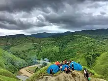
Besides the Shirui lily, the district is known for many natural wonders like the Khangkhui Mangsor, Mova (cave) which is one of the oldest archeological cave of India. Ukhrul town, the headquarters of the district, has also many scenic places like the Duncan park, the Japanese pond, and Elshadai park. At the southern part of the town, about 22 km lies the majestic Phangrei (bone of contention between two villages) which is an ideal picnic spot. The district is also home to many waterfalls, including Khayang waterfall, which is about 20 km from Ukhrul. There is also another picnic spot for youngsters called KNC river (Khangkhui, Nungshong Choithar). In the past this spot was called Saibai Kong; the title was given by Choithar Headman during kingship period.
Ukhrul is also a tourist hotspot of Manipur state. It is known for its hospitality and festivals. Almost every month festivals are celebrated by different villages and towns. The chief festivals of the Tangkhuls are Luira (seed sowing festival), Mangkhap (resting feast), Thisham (feast for the departed), and Thareo (harvest festival). Longpi village is known for its authentic Tangkhul cuisine during the Luira festival. While Ringui village is known for its celebration of Luira festival, during the festival the village comes alive with the traditional dances (bridal dance, parade of the virgin dance, festive dance and war dance) and songs. A war dance is performed during this festival. Ringui village is also known for production of films, music and plays of the Tangkhuls.
Education
In earlier days when education was sparse and primitive, Ukhrul was a well sought after place for the different tribes of the north east. The first school was set up by the then missionary Rev. William Pettigrew in 1896. Since then, not only has the place increased in the number of schools and colleges but it has produced many scholars and professionals in various fields. The first tribal person from the north east to teach in the prestigious Delhi University hails from the district (Prof. Horam). Today, with more than 90% literate population, Ukhrul is considered as the most educated town of the state next to the capital city Imphal. Some of the well known schools of the town are Sacred Heart Higher Secondary School, Alice Christian Higher Secondary School, Ktl Excel Higher Secondary School, Little Angels School, Savio School, Blesso Montessori School, Holy Spirit School, Patkai Academy, Juniors Academy, Sentinel College, Saint John School and Pettigrew College, Kendriya Vidyalaya and Jawahar Lal Novadaya Vidyalaya .
Though the Tangkhuls are a highly educated community, hardly have they abandoned the traditional way of life. In many villages, to the delights of the tourist, one still sees the enchanting traditional lives of the past. The highest cultural and judicial institution of the Tangkhuls is the Tangkhul Naga Long, which was established in 1929 under the name all Tangkhul students conference. Realising the need of an organization that covers the whole community the organisation was changed to the Tangkhul Long in 1936. To this day all the disputes within the community is settled through the court of the LONG (organisation).
See also
- List of Naga people
- List of Naga tribes
- List of Naga ethnic groups
- List of Naga languages
References
- "Ukhrul District". OurVillageIndia.com.
- https://censusindia.gov.in/2011census/dchb/DCHB_A/14/1408_PART_A_DCHB_UKHRUL.pdf p-19
- Ruivah, Khashim (1993). Social Changes Among the Nagas (Tangkhul). India: Cosmo Publications. p. 173.
- Shimray, R.R (1985). Origin and Culture of Nagas. India: Pamleiphi Shimray. p. 103.
- Dena, Lal (2010). In Search of Identity. India: Akansha Publishing House. p. 45. ISBN 9788183701341.
- Horam, Mashangthei (1975). Naga Polity. India: B.R. Publishing Corporation. p. 64. ISBN 9780883866993.
- Horam, M. (31 December 1900). "'Naga Polity' (with special reference to AO, angami and tangkhul tribes)". University.
- Leklai, Huileng (2012). "Historical geography of ukhrul and adjoining areas". INFLIBNET.
- "Oldest And The First Established Church Of Manipur, Phungyo Baptist Church, Ukhrul » Ukhrul Times". Ukhrul Times. Retrieved 23 October 2020.
- December 9, Manogya Loiwal; December 19, 2016UPDATED:; Ist, 2016 11:51. "7 new districts formed in Manipur amid opposition by Nagas". India Today. Retrieved 23 October 2020.CS1 maint: extra punctuation (link) CS1 maint: numeric names: authors list (link)
- "Manipur Creates 7 New Districts". NDTV.com. Retrieved 23 October 2020.
- Laithangbam, Iboyaima (31 December 2016). "New districts to stay, says Manipur CM". The Hindu. ISSN 0971-751X. Retrieved 23 October 2020.
- "Creation of new districts could be game-changer in Manipur polls". Hindustan Times. 20 December 2016. Retrieved 23 October 2020.
- Janavahini (preface): Birendra Kumar Bhattacharya: sahitya akademy press: 1983
- https://www.youthkiawaaz.com/2019/10/shirui-lily-and-the-shift-from-mythology-to-possible-extinction/#:~:text=The%20research%20has%20established%20the,dwarf%20bamboo%20species%20'Machun'.
- http://e-pao.net/epSubPageExtractor.asp?src=education.Science_and_Technology.Implications_of_climate_change_to_Shirui_Lily_and_response_of_Churches_Part_1_By_Somi_Kasomwoshi
- https://shodhganga.inflibnet.ac.in/bitstream/10603/39215/7/07_chapter%201.pdf
- http://legislative.gov.in/sites/default/files/A1971-76_0.pdf
- "District Census 2011". Census2011.co.in. 2011. Retrieved 30 September 2011.
- US Directorate of Intelligence. "Country Comparison:Population". Retrieved 1 October 2011.
Sao Tome and Principe 179,506 July 2011 est.
External links
| Wikimedia Commons has media related to Ukhrul district. |
- Ukhrul District of Manipur
- Ukhrul, India page at Falling Rain Genomics
Places adjacent to Ukhrul district | ||||||||||
|---|---|---|---|---|---|---|---|---|---|---|
| ||||||||||
| State symbols | |
|---|---|
| Topics | |
| Languages | |
| Administration |
|
| Districts | |
| Municipal Corporation | |
| Municipalities | |
| Proposed Municipalities | |
| Town Councils | |
| Minor Townships | |
| Sport | |