Geology of Reykjanes Peninsula
The Reykjanes Peninsula (in Icelandic: Reykjanesskagi) in southwest Iceland is the continuation of the mostly submarine Reykjanes Ridge, a part of the Mid-Atlantic Ridge, on land and reaching from Esja in the north and Hengill in the east to Reykjanestá in the west.[1] Suðurnes (transl. Southern Peninsula) is an administrative unit covering part of Reykjanes Peninsula.
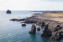
.jpg.webp)

Origin
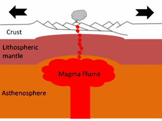
The two most important factors for the existence of Iceland, rifting in combination with a hot spot, an upwelling of unusual quantities of magma from the mantle, were also responsible for the existence of Reykjanesskagi.[2]
Reykjanes Peninsula originated in a so-called rift jump 6-7 million years ago. At this time, the active Snæfellsnes-Skagi rift had drifted so far to the west and away from the presumed steady place hot spot, that activity shifted eastwards in direction of this mantle plume which is now thought to be situated under the big glacier shield of Vatnajökull.[1]Outcropping rocks have ages from 3.2 mill. years (Esja) to the present.[3]
Volcanism and glaciations
The topography of Reykjanes Peninsula was formed esp. by glaciers and volcanism, basaltic lava fields covering a good part of the peninsula, in between volcanoes of subglacial as well as subaerial origin, namely tuyas, hyaloclastic ridges (tindars), shield volcanoes and crater rows.[1] Some volcanic systems are even (partially) submarine, so that there is a pronounced continuation between the volcanism of Reykjanes Ridge and the one on Reykjanes Peninsula.
Tertiary lavas, sediments and volcanoes around Reykjavík
Famous in the area of Reykjavík is the so called Grágrýti (Gray Lava). These tertiary basalt lava layers cover for a good part the ground around and under the capital city; but their exact origin is currently unknown.[4]
Also it is thought that the small hills within the city, such as Öskuhlíð, some of which were islands after the cold spells of glaciation, could be small shield volcanoes from warm spells of the glaciations.[5]
But it is known that during the Plio-Pleistocene (from 3.2 – 1.8 million years BP) two central volcanoes were active in the region of today’s Reykjavík, Viðeyvolcano and Stardalsvolcano, both of them partially formed Esja and the smaller mountains near Reykjavík like Úlfarsfell and the hills on the islands and small peninsulas like Viðey and Kjarlarnes.[4]
Volcanic and glacial sediments crop out at some places around Reykjavík, especially in Fossvogur.[6]
Volcanoes of subglacial origin
As Iceland was heavily ice covered during the glaciations, and even completely ice covered during parts of them, there are hundreds of subglacially formed volcanoes to be found. On Reykjanes Peninsula glaciers stayed until around 15.000 -12.000 years ago.[1]
Most subglacial edifices are thought to be Weichselian and just some of them older.[1]
The subglacial volcanoes can be identified according to type as tuyas (bigger edifices whose upper parts are covered by the products of subaerial eruptions), hyaloclastite ridges (also called tindars) which means elongated subglacially formed volcanic edifices of different sizes (most of them) and cone-like subglacial mounds (very rare). On the other hand, there are many hyaloclastite ridges, actually most of them consisting of mixtures of pillow lavas, hyaloclastite and lapilli tuff. [7] There are also elongated pillow structures, called pillow tindars by Pedersen.[1] Examples on Reykjanes peninsula are Sveifluháls, Núpshlíðarháls, Undirhlíðar, Helgafell (Hafnarfjörður) and Vífilsfell.[1]
The tuyas are often sorted according to their form (morphology) into flat-topped tuyas, elongated tuyas, conical tuyas and complex tuyas (see M.T. Russell[1]).
Many different types are to be found on Reykjanes Peninsula; mixed types or intergrown hyaloclastite ridges (tindars) and tuyas also exist. The prominent igneous rock is basalt, though there are also some basaltic andesite or andesite volcanoes on Reykjanes, like the tindars Húsmúli and Stapafell within the Hengill Volcanic System. [1]
Examples for tuyas on Reykjanes Peninsula are Keilir (conical tuya), Geitafell (Brennisteinsfjöll), Geitahlíð and Þorbjörn are flat-topped tuyas whereas Þorðarfell and Syllingarfell (Reykjanes Volcanic System) are complex tuyas.[1]
Postglacial shield volcanoes
"The Holocene shield volcanoes even represent the great bulk of magma production in this part of Iceland and the base of many other volcanic landforms. At the end of the glacioisostatic period" - i.e. after glaciation, when the weight of the glaciers was no longer pushing down the flexible crust of the Earth and there was an uplift - "olivine tholeiites were erupted which have been proposed to constitute about 60% by volume of all post-glacial lava products on the Reykjanes Peninsula."[8]
The postglacial shield volcanoes today are situated at the periphery of fissure systems. They erupted after the Weichselian glaciation, i.e. after 15.000 – 12.000 years ago.[1]
"These shields are mostly circular in form, built up from pahoehoe lavas and composed of a low-sloping lava cone surrounded by a lava apron";[1] the older shields are made from picrite, the younger, bigger ones from olivine-tholeiite. They were probably formed in long-lived eruptions (years to decades).[1] The best known edifices are Selvogsheiði (height 176 m, basal width 4.8 km, summit width 0.7 km, volume 0.64 km3[1] 8,200 years old according to A. Hjartarson; Þráinskjöldur, 12,500 years old, volume 5.2 km3; Heiðin há, 7,500 years old, volume 6 km3; and Sandfellshæð, 12,800 years old, 4.5 km3.[9] Sandfellshæð is a very regularly constructed shield volcano and the biggest in the southern part of Reykjanes Peninsula.[10] Another important shield volcano on Reykjanes Peninsula is Leitin, formed around 5,000 years ago.
Reykjanes Volcanic Belt
Since the end of the Pleistocene glaciation (15.000 – 11.000 years ago in the region),[1] Holocene volcanoes have done their work. The Reykjanes Volcanic Belt, one of the present day volcanic zones of Iceland, is connected to the submarine Reykjanes Ridge (RR), and consists (depending on author) of 3 to 6 or even 7 volcanic systems, arranged en echelon and in an average 40° angle to the spreading direction NE–SW over the peninsula. These volcanic systems are: Eldey Volcanic System (mostly submarine), Reykjanes Volcanic System (not to be confounded with Reykjanes Peninsula), Svartsengi Volcanic System (often thought to be a part of Reykjanes Volcanic System), Krýsuvík Volcanic System (mostly including Fagradalsfjall and Trölladyngja (Krýsuvík)), Brennisteinsfjöll Volcanic System and Hengill Volcanic System, the latter also stretching up to the north and into the West Volcanic Zone.[11] Because of their location on top of a rift segment, these volcanic systems show a tendency for fissure eruptions. The last eruptions in the region took place in the 13th century.[12]
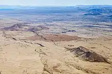
Tectonics
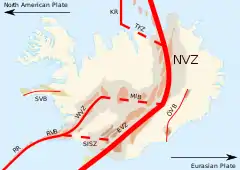
.jpg.webp)
As is usual within rift zones, tectonics also play an important role on Reykjanes Peninsula. Earthquakes are often registered. They may reach up to M6, but most of the earthquakes are small ones.[13] These earthquakes often take place within the volcanic systems, but there are also many faults, fractures and fissures in N-S direction on the peninsula. Additionally, the region is influenced by the South Iceland Seismic Zone. This southern transform zone of Iceland is located between the West Volcanic Zone and the East Volcanic Zone. The bigger earthquakes there not only are felt and registered on Reykjanes Peninsula, but they can also trigger medium sized quakes in this region, as last seen in 2008 and especially in 2000.[14]
On 20 October 2020, a 5.6 earthquake was registered on Reykjanes Peninsula at Núpshlíðarháls within Krýsuvík (volcanic system).[15] It was followed up by over 1000 aftershocks[16][17] and is part of a series stretching over more than half a year and still ongoing at time of writing.
External links
References
- G.B.M. Pedersen, P. Grosse: Morphometry of subaerial shield volcanoes and glaciovolcanoes from Reykjanes Peninsula, Iceland: Effects of eruption environment. Journal of Volcanology and Geothermal Research 282, (2014), 115-133. Retrieved 21 August 2020.
- Thor Thordarson, Armann Hoskuldsson: Iceland. Classic geology of Europe 3. Harpenden 2002, p. 8-10
- Thor Thordarson, Armann Hoskuldsson: Iceland. Classic geology of Europe 3. Harpenden 2002, p. 48
- Freyr Pálsson: Jarðfræði Reykjavíkursvæðisins. Háskóla Íslands, Raunvísindadeild, Jarð- og landfræðiskor. (2007)
- Snæbjörn Guðmundsson: Vegavísir um jarðfræði Íslands. Reykjavík 2015, p. 28-30
- Snæbjörn Guðmundsson: Vegavísir um jarðfræði Íslands. Reykjavík 2015, p. 31-33
- Edwards, B.R., Gudmundsson, M.T., Russell, J.K., 2015. Glaciovolcanism. In: Sigurdsson, H., Houghton, B., Rymer, H., Stix, J., McNutt, S. (Eds.), The Encyclopedia of Volcanoes, pp. 377–393. ISBN 9780123859389
- M.A.M. Gee et al.: Glacioisostacy controls chemical and isotopic characteristics of tholeiites from the Reykjanes Peninsula, SW Iceland. / Earth and Planetary Science Letters 164 (1998) 1–5
- Árni Hjartarson: Postglacial lava production in Iceland. Okustofnun. Greinar starfsmanna. (2003) Retrieved 06 August 2020.
- Helgi Páll Jónsson: Eldfjallagarður og jarðminjasvæði á Reykjanesskaga. Jarðvísindadeild Háskóli Íslands 2011. MS ritgerð. Leiðbeinendur Ólafur Ingólfsson. Retrieved 17. ágúst 2020.
- See eg. Helgi Páll Jónsson: Eldfjallagarður og jarðminjasvæði á Reykjanesskaga. Jarðvísindadeild Háskóli Íslands 2011. MS ritgerð. Leiðbeinendur Ólafur Ingólfsson. Accessed 17. ágúst 2020.
- Thor Thordarson, Armann Hoskuldsson: Iceland. Classic geology of Europe 3. Harpenden 2002, p. 68
- See eg.: Reykjanes Peninsula. Icelandic Met Office
- Clifton, A., etal.: Surface effects of triggered fault slip on Reykjanes Peninsula, SW Iceland. Tectonophysics 369 (2003) 145– 154 Retrieved 21 August 2020.
- Stór jarðskjálfti á Reykjanesskaga fannst vel. RÚV, 20 October 2020.
- https://en.vedur.is/earthquakes-and-volcanism/earthquakes/reykjanespeninsula/ See also IMO, 21 October 2020.
- See also: Skjálfti af stærð 5,6 á Reykjanessskaga. IMO 20 October 2020.