Wellington, New South Wales
Wellington is a town in the Central Western Slopes region of New South Wales, Australia, located at the junction of the Macquarie and Bell Rivers. It is within the local government area of Dubbo Regional Council. The town is 362 kilometres (225 mi) northwest of Sydney on the Great Western Highway and Main Western Railway, and 50 km southeast of Dubbo, the main centre of the Central Western Slopes region.
| Wellington New South Wales | |||||||||
|---|---|---|---|---|---|---|---|---|---|
Wellington | |||||||||
| Coordinates | 32°33′0″S 148°56′0″E | ||||||||
| Population | 4,077 (2016 census)[1] | ||||||||
| Postcode(s) | 2820 | ||||||||
| Elevation | 305 m (1,001 ft)[2] | ||||||||
| Location | |||||||||
| LGA(s) | Dubbo Regional Council | ||||||||
| County | Wellington | ||||||||
| State electorate(s) | Dubbo | ||||||||
| Federal Division(s) | Parkes | ||||||||
| |||||||||
History
The area was originally occupied by the Wiradjuri people. New South Wales Surveyor-General John Oxley was the first European to visit the area, in 1817. He named it "Wellington Valley" after Arthur Wellesley, 1st Duke of Wellington.[3]
The settlement of Wellington was established in February 1823 by Lieutenant Percy Simpson as a convict settlement.[4] Squatters started settling along the Macquarie Valley and in 1832 CMS was established in the settlement to teach Christianity to the Aboriginal people of the area. The convict settlement ceased in 1831 but in 1840, a village called Montefiores was established on the north side of the Macquarie River crossing.[5][6] The Town of Wellington, on the south bank of the Macquarie River opposite Montefiores, was gazetted in 1846, and on 20 March 1885, Wellington was proclaimed a town.[7][8]
The first local government body covering Wellington was the Wellington Municipal District, proclaimed in 1879. In 1950 it was amalgamated with Macquarie Shire and part of Cobbora Shire to form Wellington Shire. There was a number of transfer of areas with adjoining shires, and in 2016 Wellington Shire was amalgamated with the local government area of Dubbo City to form Western Plains Regional Council.
Wellington is the second oldest New South Wales settlement west of the Blue Mountains.[9] One of its hotels, the Lion of Waterloo, established by Nicolas Hyeronimus in 1842, is the oldest operating west of the Blue Mountains.
Near to The Lion of Waterloo is the location of the last recorded duel fought on Australian soil, in 1854.[6]
The extension of the Main Western Railway from Orange to Wellington opened on 1 June 1880.[10][11] The line was subsequently extended to Dubbo in February 1881.
As a regional centre Wellington benefited by the development of the gold mining industry in the district from the 1850s. Initially this was working alluvial deposits of gold but later focused on the mining of quartz reefs. Among the mining districts was Mitchells Creek located 8 miles to the north east near the locality of Bodangora.[12]
Heritage listings
Wellington has a number of heritage-listed sites, including:
- 9 Amaroo Drive: John Fowler 7nhp Steam Road Locomotive[13]
- Curtis Street: Wellington Convict and Mission Site[14]
- 21 Maughan Street: Wellington Post Office[15]
- University Road: Blacks Camp[16]
Population
According to the 2016 census of Population, there were 4,077 people in Wellington.
- Aboriginal and Torres Strait Islander people made up 27.8% of the population.
- 82.4% of people were born in Australia.
- 86.8% of people only spoke English at home.
- The most common responses for religion were Anglican 27.0%, Catholic 25.4% and No Religion 19.4%.[1]
Economy
Wellington is the centre of rich agricultural land. While alfalfa and vegetables are grown on lands on the river, wheat, wool, lambs and beef cattle are grown on surrounding pastures. The town acts as a commercial centre for the surrounding district.
In September 2008, the Wellington Correctional Centre was opened. A Probation and Parole Office was also opened in the centre of town. Wellington Council hopes this will stimulate economic growth in the area, due to increasing employment opportunities and the need for non-locals to utilise Wellington facilities.
The local newspaper The Wellington Times, a Rural Press title, is published three times a week with a circulation in the region of around 1000.[17]
There is a popular Community Radio Station operating on a frequency of 91.5 MHz FM.
Climate
Wellington has a humid subtropical climate (Cfa) with hot summers and cool winters, and uniform rainfall throughout the year. The town is rather sunny, getting 138.1 clear days annually. In January, the average minimum temperature in the town is 16.9 °C and the average maximum is 32.9 °C, while in July the average minimum is 2.2 °C and the average maximum is 15.2 °C.[2]
| Climate data for Wellington (D&J Rural) | |||||||||||||
|---|---|---|---|---|---|---|---|---|---|---|---|---|---|
| Month | Jan | Feb | Mar | Apr | May | Jun | Jul | Aug | Sep | Oct | Nov | Dec | Year |
| Record high °C (°F) | 43.7 (110.7) |
45.0 (113.0) |
39.0 (102.2) |
33.9 (93.0) |
27.5 (81.5) |
26.0 (78.8) |
24.0 (75.2) |
28.8 (83.8) |
33.4 (92.1) |
39.5 (103.1) |
43.0 (109.4) |
43.1 (109.6) |
45.0 (113.0) |
| Average high °C (°F) | 33.0 (91.4) |
32.1 (89.8) |
29.4 (84.9) |
24.6 (76.3) |
19.8 (67.6) |
16.0 (60.8) |
15.2 (59.4) |
17.0 (62.6) |
20.8 (69.4) |
24.9 (76.8) |
28.5 (83.3) |
31.6 (88.9) |
24.4 (75.9) |
| Average low °C (°F) | 16.9 (62.4) |
16.6 (61.9) |
13.9 (57.0) |
9.4 (48.9) |
5.7 (42.3) |
3.5 (38.3) |
2.2 (36.0) |
3.0 (37.4) |
5.4 (41.7) |
8.6 (47.5) |
12.2 (54.0) |
15.1 (59.2) |
9.4 (48.9) |
| Record low °C (°F) | 6.5 (43.7) |
6.5 (43.7) |
1.7 (35.1) |
−1.0 (30.2) |
−3.9 (25.0) |
−5.7 (21.7) |
−5.7 (21.7) |
−4.6 (23.7) |
−3.0 (26.6) |
−2.0 (28.4) |
1.6 (34.9) |
3.2 (37.8) |
−5.7 (21.7) |
| Average rainfall mm (inches) | 59.2 (2.33) |
50.9 (2.00) |
50.7 (2.00) |
44.8 (1.76) |
47.0 (1.85) |
50.9 (2.00) |
48.9 (1.93) |
48.7 (1.92) |
44.7 (1.76) |
56.0 (2.20) |
58.1 (2.29) |
56.6 (2.23) |
615.5 (24.23) |
| Average precipitation days | 5.5 | 5.0 | 5.1 | 4.6 | 6.1 | 7.9 | 8.2 | 7.7 | 6.5 | 6.7 | 6.3 | 5.9 | 75.5 |
| Average afternoon relative humidity (%) | 36 | 39 | 41 | 44 | 53 | 57 | 55 | 50 | 46 | 42 | 38 | 34 | 45 |
| Source: Bureau of Meteorology[2] | |||||||||||||
Transport links
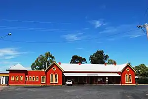
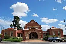
Welington station is served by a daily NSW TrainLink XPT service which runs between Sydney and Dubbo.[18]
The closest commercial airport is that of Dubbo. QantasLink and Regional Express service the airport three-five times daily from Sydney. A small airport (Bondangora Airport) for private planes exists twelve kilometres east of Wellington.
Ogden's Coaches operates return services to Dubbo, with one extending to Narromine as a through-routed service with the Narromine link.
Nearby attractions
Lake Burrendong, a man-made lake, is located 30 kilometres south of the town. Its capacity is three and a half times that of Sydney Harbour and supplies water for irrigation schemes downstream. It is also a popular location for anglers, sailors and water skiers. Burrendong Arboretum is a sanctuary for endangered Australian flora and covers 1.60 km².
The nearby Wellington Caves feature the Cathedral Cave with the massive Altar Rock and has a viewable underground river running at the bottom. Immediately to the East of the township lies the Catombal Range with magnificent bushwalks in and around Mt Arthur and Mt Wellesley.
The Wellington Boot, a country racing festival is held in March and April annually. The Bell River Wine Estate is nearby.
Notable residents
- Tim Storrier - Award winning artist.
- Media stars John Laws, Laurie Oakes and Ray Martin all lived in Wellington
- Ben Austin – Paralympian, grew up in Wellington
- Millicent Bryant - first woman in Australia to earn a pilot licence, born at Apsley, Wellington.
- Max Cullen – actor
- Silvanus Daniel - politician
- Terry Fahey – former professional rugby league footballer for South Sydney Rabbitohs, Eastern Suburbs and Canberra Raiders
- Blake Ferguson – NRL player for the Parramatta Eels, played junior Rugby League with the Wellington Cowboys
- Nicolas Hyeronimus – pioneering innkeeper, merchant, pastoralist and inaugural MLA for Wellington
- Colleen McCullough – author, born in Wellington
- Ian O'Brien – Olympic gold medallist in the 200 m breaststroke at the 1964 Summer Olympics, grew up in Wellington
- Tyrone Peachey – NRL player.
- Trent Runciman - Former NRL player
- Kotoni Staggs - NRL player for the Brisbane Broncos
- Brent Naden - NRL Player, born in Wellington
References
- Australian Bureau of Statistics (27 June 2017). "Weillington (NSW) (State Suburb)". 2016 Census QuickStats. Retrieved 4 August 2017.

- "Wellington (D&J Rural)". Climate statistics for Australian locations. Bureau of Meteorology. March 2019. Retrieved 27 April 2013.
- "John Oxley discovers Wellington Valley". Oxley Museum, Wellington NSW. Retrieved 27 April 2013.
- "THE DISCOVERY AND OCCUPATION OF WELLINGTON VALLEY". Wellington Times. New South Wales, Australia. 23 October 1950. p. 8. Retrieved 13 March 2019 – via National Library of Australia.
- "Wellington Valley and Wellington". Wellington Times (3162). New South Wales, Australia. 8 September 1921. p. 2. Retrieved 13 March 2019 – via National Library of Australia.
- "Wellington". Sydney Morning Herald. 8 February 2004. Retrieved 13 March 2019.
- "VILLAGE OF WELLINGTON". New South Wales Government Gazette (33). New South Wales, Australia. 24 April 1846. p. 503. Retrieved 13 March 2019 – via National Library of Australia.
- "Wellington". Geographical Names Register (GNR) of NSW. Geographical Names Board of New South Wales. Retrieved 11 August 2013.
- "Wellington History". Wellington NSW. Retrieved 13 March 2019.
- "Wellington Railway Precinct". Office of Environment and Heritage. Retrieved 13 March 2019.
- "Opening of the Railway from Orange to Wellington". Newcastle Morning Herald and Miners' Advocate. VIII (1855). New South Wales, Australia. 2 June 1880. p. 2. Retrieved 13 March 2019 – via National Library of Australia.
- Osborne, Idle 1975 Annual Report Compilation, Wellington Division – Dubbo Sheet 1875-1974, Department of Mines NSW, ARC080.
- "John Fowler 7nhp Steam Road Locomotive". New South Wales State Heritage Register. Office of Environment and Heritage. H01867. Retrieved 18 May 2018.
- "Wellington Convict and Mission Site - Maynggu Ganai". New South Wales State Heritage Register. Office of Environment and Heritage. H01859. Retrieved 18 May 2018.
- "Wellington". New South Wales State Heritage Register. Office of Environment and Heritage. H01415. Retrieved 18 May 2015.
- "Blacks Camp". New South Wales State Heritage Register. Office of Environment and Heritage. H01865. Retrieved 18 May 2018.
- "Wellington Times". Fairfax Regional Media. Retrieved 27 April 2013.
- "Western timetable". NSW Trainlink. 7 September 2019.
External links
| Wikimedia Commons has media related to Wellington, New South Wales. |
| Authority control |
|---|