West Tripura district
West Tripura is an administrative district in the state of Tripura in India. The district headquarters are located at Agartala. As of 2012 it is the most populous district of Tripura (out of 8).[1]
West Tripura | |
|---|---|
District | |
.JPG.webp) River scene in Agartala, West Tripura | |
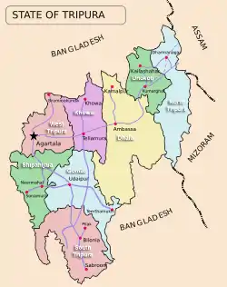 Tripura's eight (8) districts | |
| State | Tripura |
| Country | India |
| Seat | Agartala |
| Government | |
| • District Magistrate | Dr. Sandeep Mahatme,IAS |
| • Superintendent of police | Shri Manik Das, TPS Gr-I, |
| Area | |
| • Total | 983.63 km2 (379.78 sq mi) |
| Population (2011) | |
| • Total | 1,725,739 |
| • Density | 1,800/km2 (4,500/sq mi) |
| Languages | |
| • Official | Bengali, English |
| Time zone | UTC+05:30 (IST) |
| ISO 3166 code | IN-TR-WT |
| Spoken languages | Bengali, Kokborok, English, |
| Ethnicity | Bengali, Tripuri, Chakma |
| Website | http://westtripura.nic.in/ |
Geography
Climate
| Agartala | ||||||||||||||||||||||||||||||||||||||||||||||||||||||||||||
|---|---|---|---|---|---|---|---|---|---|---|---|---|---|---|---|---|---|---|---|---|---|---|---|---|---|---|---|---|---|---|---|---|---|---|---|---|---|---|---|---|---|---|---|---|---|---|---|---|---|---|---|---|---|---|---|---|---|---|---|---|
| Climate chart (explanation) | ||||||||||||||||||||||||||||||||||||||||||||||||||||||||||||
| ||||||||||||||||||||||||||||||||||||||||||||||||||||||||||||
| ||||||||||||||||||||||||||||||||||||||||||||||||||||||||||||
District Profile
The information provided below are taken from a book based on 2012 statistics, all the names, infos, details, etc. are in effect from and on 2012[2]
| Nos | Info | Details |
|---|---|---|
| 1 | Inauguration date | 1 September 1970 |
| 2 | Present DM | Sandeep Mahatme (IAS) |
| 3 | First DM | R Ghosh (IAS) from 5 November 1951 to 26 September 1954. |
| 4 | Present SP | RGK Rao (IPS) |
| 5 | Area in km2 | 983.63 |
| 6 | Population Density | 1005 |
| 7 | Population(2011) | 988,192 |
| 8 | Rural Population | 577,453 (58%) |
| 9 | Urban Population | 410,739 (42%) |
| 10 | Literacy | 91.31% (♂ & ♀ 94% & 88% respectively) |
| 11 | BPL Population | Rural 62%, Urban 30% |
| 12 | Cultivated Land | 40% of district area |
| 13 | Irrigable Land | 14623 Hectares |
| 14 | Power Connectivity | 140/147 Villages |
| 15 | Self Help Groups | 5468 |
| 16 | Assembly Constituencies | 14 (SDR: 8 MNP:3 JRN: 3) |
| 17 | TTAADC Constituencies | 5 (Sadar: 1 MNP:2 JRN: 2) |
| 18 | Voters | 583,434 |
| 19 | No. of Colleges | 21 |
Divisions
West Tripura District has Threesub-divisions:
- Sadar Subdivision
- Mohanpur Subdivision
- Jirania Subdivision
West Tripura District has 9 Blocks:
- Mohanpur
- Hezamara
- Lefunga
- Bamutia
- Old Agartala
- Jirania
- Mandwi
- Belbari
- Dukli
Lok Sabha constituencies
West Tripura district is located in two Lok Sabha constituencies: Tripura West (shared with South Tripura district), and Tripura East (shared with South Tripura, Dhalai and North Tripura districts).
Religion and Demographics

According to the 2011 census West Tripura district has a population of 1,725,739,[1] roughly equal to the nation of The Gambia[4] or the US state of Nebraska.[5] This gives it a ranking of 281st in India (out of a total of 640).[1] The district has a population density of 576 inhabitants per square kilometre (1,490/sq mi) .[1] Its population growth rate over the decade 2001-2011 was 12.5%.[1] West Tripura has a sex ratio of 964 females for every 1000 males,[1] and a literacy rate of 88.91%.[1]
| West Tripura | Urban Pop. % of total population | Sex ratio (♀ per 1000 ♂) | Density Population |
|---|---|---|---|
| 1981 | 15.29 | 941 | 364 |
| 1991 | 24.29 | 946 | 963 |
| 2011 | 42.00 | - | 1005 |
Flora and fauna
In 1987 West Tripura district became home to the Sipahijola Wildlife Sanctuary, which has an area of 18.5 km².[6]
References
- "District Census 2011". Census2011.co.in. 2011. Retrieved 30 September 2011.
- http://www.tripurainfo.com
- "Census of India – Socio-cultural aspects". Government of India, Ministry of Home Affairs. Archived from the original on 20 May 2011. Retrieved 2 March 2011.
- US Directorate of Intelligence. "Country Comparison:Population". Retrieved 1 October 2011.
Gambia, The 1,797,860 July 2011 est.
- "2010 Resident Population Data". U. S. Census Bureau. Retrieved 30 September 2011.
Nebraska 1,826,341
- Indian Ministry of Forests and Environment. "Protected areas: Tripura". Archived from the original on 25 March 2012. Retrieved 25 September 2011.
External links
| Wikimedia Commons has media related to West Tripura. |
Places adjacent to West Tripura district | ||||||||||
|---|---|---|---|---|---|---|---|---|---|---|
| ||||||||||
| State symbols | |
|---|---|
| Topics | |
| Government |
|
| Districts | |
| Cities and towns | |
| Culture | |