Westbury-on-Trym
Westbury on Trym is a suburb and council ward in the north of the City of Bristol, near the suburbs of Stoke Bishop, Westbury Park, Henleaze, Southmead and Henbury, in the southwest of England.
| Westbury on Trym | |
|---|---|
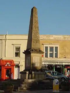
 Westbury-on-Trym War Memorial | |
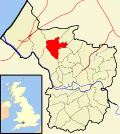
 Boundaries of the city council ward | |
| Population | 10,754 (2011.Ward)[1] |
| OS grid reference | ST570773 |
| Unitary authority | |
| Region | |
| Country | England |
| Sovereign state | United Kingdom |
| Post town | BRISTOL |
| Postcode district | BS9/10 |
| Dialling code | 0117 |
| Police | Avon and Somerset |
| Fire | Avon |
| Ambulance | South Western |
| UK Parliament | |
With a village atmosphere, the place is partly named after the River Trym, which flows through it.
History
The origins of Westbury on Trym predate those of Bristol itself. In the 6th century Westbury was in the territory of Hwicce, which became part of Mercia in the 7th century.
The earliest record of Westbury, in the form Uuestburg, was in a charter dated between 793 and 796. -burg or -bury was from the Old English burh, which usually meant a fort but could also mean a fortified house or a minster. The name may refer to a minster already present on the site of the parish church in the 8th century. It is not clear why the burh was "west". It possibly referred to the westernmost minster in the territory of Hwicce.[2]
At the end of the 8th century, King Offa of Mercia granted land at Westbury to his minister, Aethelmund. Early in the 9th century land at Westbury passed to the Bishop of Worcester. Later there was a monastery at Westbury, probably initially a secular one, with married clergy. This changed towards the end of the 10th century when Oswald of Worcester, in whose diocese the monastery lay, sent a party of 12 monks to follow more stringent rules at the Westbury monastery.[3] The architect Ednoth constructed a new church and other buildings. The monastery became a college with a dean and canons at the end of the 13th century. It was rebuilt in the mid-15th century to resemble a miniature castle with turrets and a gatehouse. Westbury College was dissolved in 1544 and became a private house. The Royalist Prince Rupert of the Rhine used it as his quarters during the English Civil War. When he left, in 1643, he ordered it to be set on fire so that the Parliamentarians could not make use of it. In the 20th century some of the college buildings were restored. Westbury College Gatehouse passed into the hands of the National Trust and the grounds were adapted for housing elderly people.
The current Church of the Holy Trinity dates from 1194 (although there has been a place of worship on the site since 717), with an early 13th century nave and aisles, and 15th century chancel, chapels and tower. It is a grade I listed building.[4]
The ancient parish of Westbury on Trym was a large one. It included Stoke Bishop, Redland, a large exclave comprising Shirehampton and Avonmouth, and several smaller exclaves in the parish of Henbury.[5] When the civil parish was created in 1866, Shirehampton was separated to form its own civil parish, and in 1894 Redland also became a separate civil parish. In 1904 the civil parish was abolished and absorbed into Bristol.[6] Redland remained in the ecclesiastical parish of Westbury until 1942.
Development of the village into a large suburb of Bristol was started in the 1920s and was well underway by the 30s. Many detached and semi-detached villas were built in this period. Apart from during WW2, major house building did not cease until the 60s.
Falcondale Road [7] was constructed during the 1930s to act as a bypass to the narrow twisting streets of the old village. With the opening of the Filton Bypass in the late 30s, Falcondale Road acted as a major conduit for A38 holiday traffic going to and from the South West. However, when the Filton Bypass was split into two by the construction of the Brabazon Runway in the late 40s, A38 traffic had to be directed to the original route through Filton.
Amenities
Westbury on Trym High Street has three Indian and one Thai restaurants. There is also the Villager Restaurant (Modern English) at the end of College Road, eight pubs and several cafés. The village centre is well-served for shoppers, containing banks and independent stores including book shops, craft stores, hardware shops, florists, and a number of charity shops. Two free car parks are available and a medium-sized supermarket, built on the site of the previous Carlton cinema, above which there is a ladies only gym. During 2001, a large Sainsbury's was proposed, but the opposition to the plan was so strong from local villagers that the supermarket construction was eventually scrapped. In November 2013 a Tesco Metro opened on the site of a closed pub (The Foresters Tavern) just off the central War Memorial in the Village, its coming had been the subject of much discussion in the village and had been strongly opposed by many.
Schools within the area include Elmlea Infant School, Elmlea Junior School, Bristol Free School and Westbury on Trym Church of England Academy. Independent schools include the prestigious girls' schools Badminton, which has taught pupils such as Indira Gandhi, Princess Haya of Jordan and the daughter of the Sultan of Brunei; Red Maids', the oldest surviving girls' school in England.
A new doctors' surgery has been constructed for Westbury near to the Holy Trinity Church and the Westbury Hill Car Park. This replaces the previous surgery which was housed in a building on Falcondale Road.
Canford Cemetery opened in 1903, acquiring a crematorium in 1957.
Transport
Transport routes include the A4018, which runs from the city centre to Cribbs Causeway. Westbury is served by bus routes 1, 5, 20, 55, 501, 502, 508, 624, and service X14 also connects Westbury-on-Trym with Chepstow and Newport, South Wales. The nearest railway station is Sea Mills station at Sea Mills.
Notable residents
The wealthy Bristol merchant William Canynge was dean of Westbury College from 1469 to 1474.[8]
Bishop John Carpenter (1399–1476) was an English Bishop, Provost and University Chancellor who was baptised and buried in St Peter's Church, now called Holy Trinity Church, Westbury on Trym.[9][10] The Westbury Harriers club have adapted Bishop John Carpenter's arms to use as their "crest."[11]
John Wedgwood, the horticulturist and eldest son of potter Josiah Wedgwood, lived at the old Cote House on the edge of Durdham Down from 1797 to 1806. The house, which had Gothic turrets and battlements, was demolished in 1925 to make way for retirement accommodation.[12]
The poet Robert Southey, who later in his life became one of the Lake poets and the Poet Laureate, lived in the village for a year in 1798–99, during which he wrote his Eclogues and much other poetry. His social circle at the time included the Wedgwoods of Cote House and chemist Humphry Davy, who was also living in Bristol then. Southey took part in Davy's experiments with laughing gas.[13]
William Pennefather (1816-1873), the Irish-born clergyman noted for his hymns and sermons, went to school here in the late 1820s.
Amelia Edwards the traveller, novelist and Egyptologist lived in Eastfield, at the eastern end of the village, from c. 1864 to 1892.[14]
Geoff Gollop OBE, councillor for Westbury on Trym stood to become the first elected Mayor of Bristol in the elections of 15 November 2012 but was unsuccessful.
Catherine B. Gulley an English watercolour portrait and genre painter lived at various addresses in Clifton and Westbury-on-Trym.
Dolly Tree the actress, illustrator and Hollywood costume designer was born here
Alice Roberts Ex-Resident. Surfer, Anatomist, Osteoarchaeologist, and noted Humanist. T.V. include the Channel 4 series Time Team, and Digging for History, and Neanderthal.
Sunetra Sarker the actress lives in the area.
References
- "Westbury-on-Trym" (PDF). 2011 Census Ward Information Sheet. Retrieved 26 February 2015.
- Orme, Nicholas; Cannon, Jon (2010). Westbury-on-Trym: Monastery, Minster and College (PDF). Bristol Record Society. ISBN 978 0 901538 31 4. Retrieved 23 January 2021.
- Victoria County History of Gloucestershire: The College of Westbury on Trym
- "Church of the Holy Trinity". historicengland.org.uk. Retrieved 20 February 2007.
- Great Britain Historical GIS / University of Portsmouth, Westbury on Trym AP/CP Boundary map. Retrieved 23 January 2021.
- Great Britain Historical GIS / University of Portsmouth, Westbury on Trym AP/CP. Retrieved 23 January 2021.
- Little, Bryan; Sansom, John (1999). The Story of Bristol from the Middle Ages to Today. Bristol: Redcliffe Press. p. 15. ISBN 1-900178-56-7.
- Westbury-on-Trym Parish Church and College. From the information framed at the entrance of the Church and containing the History of the Vicars etc. Info also from "Bishop Carpenters Monument" in the Chancel of the Parish Church and directly over the Sepulchre in the little Chapel beneath the Chancel.
- "'College: Westbury-on-Trym', A History of the County of Gloucester: Volume 2 (1907), pp. 106–108". British History Online. Retrieved 27 July 2010.
- "The Westbury Harriers Crest – Heraldically, our crest is described as "Paly of six gules and azure on a chevron argent three cross crosslet or; on the top of the chevron is a mitre wrought or." Westbury Harriers club crest: http://www.westburyharriers.co.uk/crest.html See also: http://www.westburyharriers.co.uk/index.html
- Kingsley, Nicholas (1992). The Country Houses of Gloucestershire, Vol.2 1660–1830. Chichester: Phillimore. pp. 109–110. ISBN 0-85033-806-9.
- Cottle, Basil (1980). Robert Southey and Bristol. Bristol: Bristol Branch of the Historical Association Pamphlets. pp. 12–14.
- Rees, Joan (1998). Amelia Edwards: Traveller, Novelist and Egyptologist. London: Rubicon. pp. 19, 66, 69. ISBN 0-948695-61-7.
External links
| Wikimedia Commons has media related to Westbury-on-Trym. |